Welcome
US 380 Denton County Feasibility Study – From I-35 to the Collin County Line
The comment period has ended for this public meeting.
Thank you for your participation in our virtual public meeting! The entire session should take no more than 20 minutes to complete. This virtual public meeting consists of presentation materials explaining the study purpose, alternatives being analyzed, and the process for evaluation. The virtual public meeting will be live from November 30, 2021 and will remain available online through the comment period deadline of January 19, 2022.
Meeting Purpose
- Inform the public of project status and present recommendations.
- Describe the project so the public can determine how they may be affected.
- Provide the public the opportunity to contribute input.
- Develop a record of public participation.

How to Navigate
- Click the arrow on the right side of your screen.
- Use the navigation bar at the left of your screen to revisit any part of the meeting.
- Click through all seven (7) pages to view all materials.
Comments
To provide a written comment at any point, click the “Comment” button at the top right of your screen. You may close the form to continue through the slides. Once finished, please make sure to hit “Submit” to confirm that your comment is sent.
Study Overview
Where is the study and what is involved?
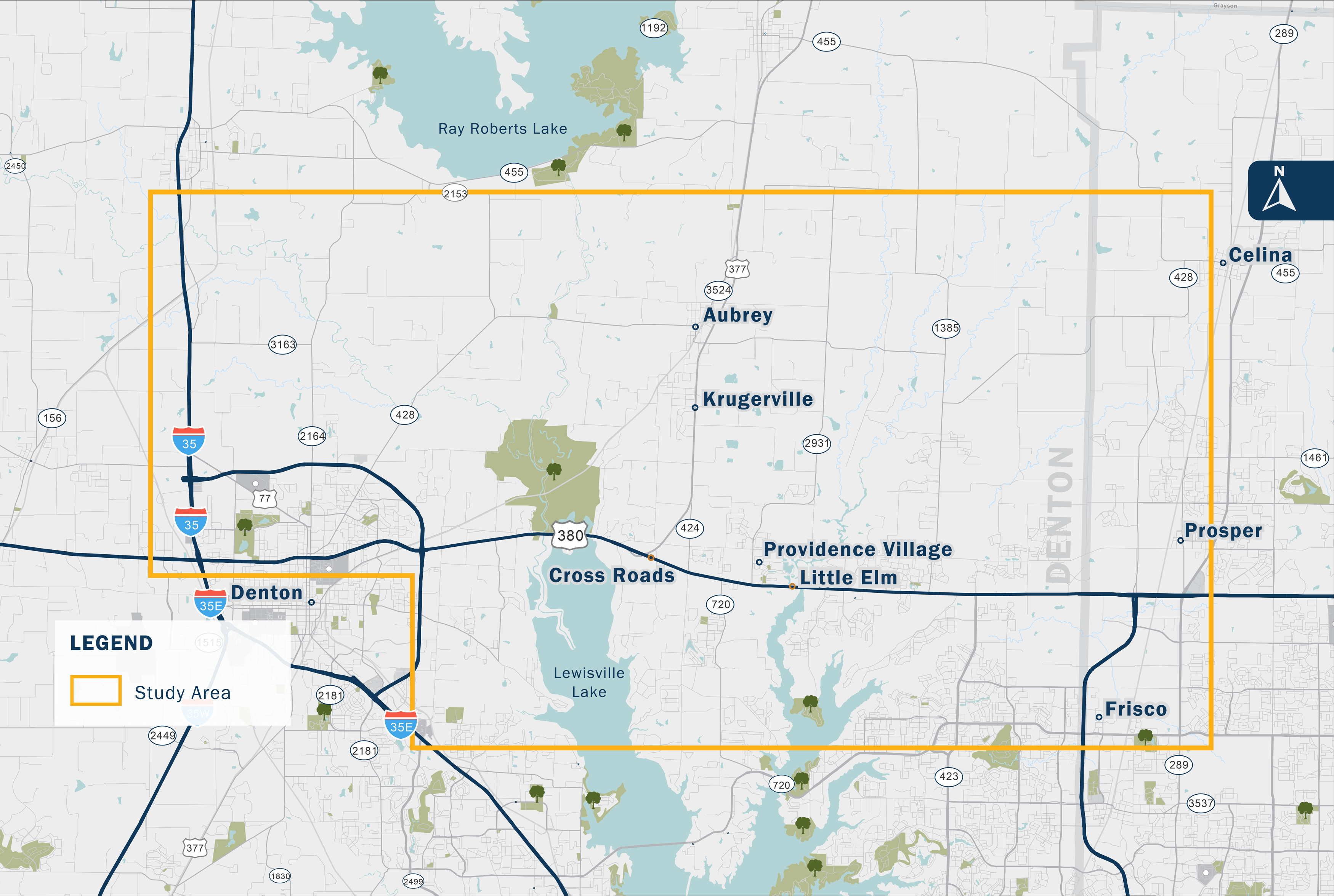
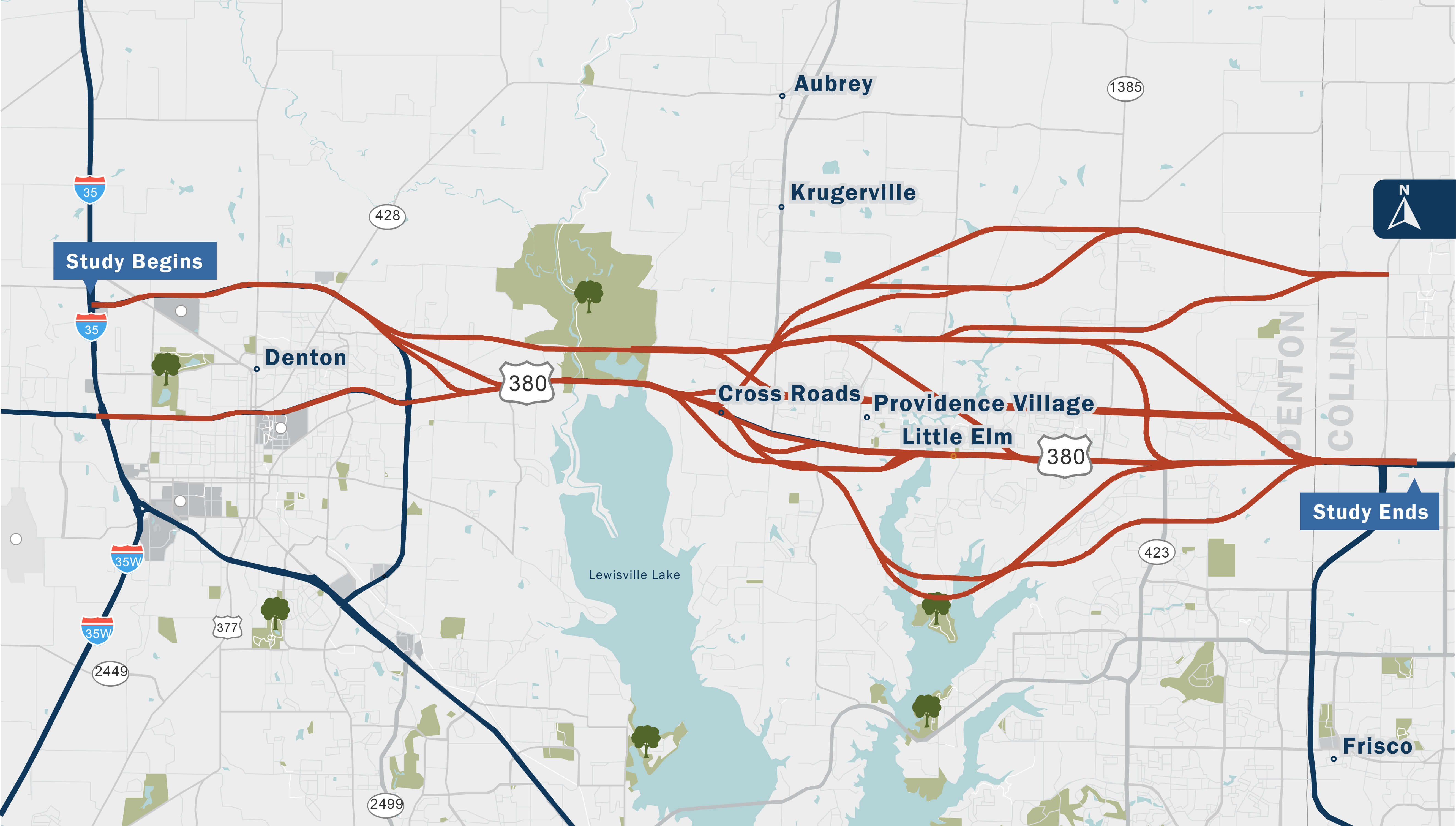
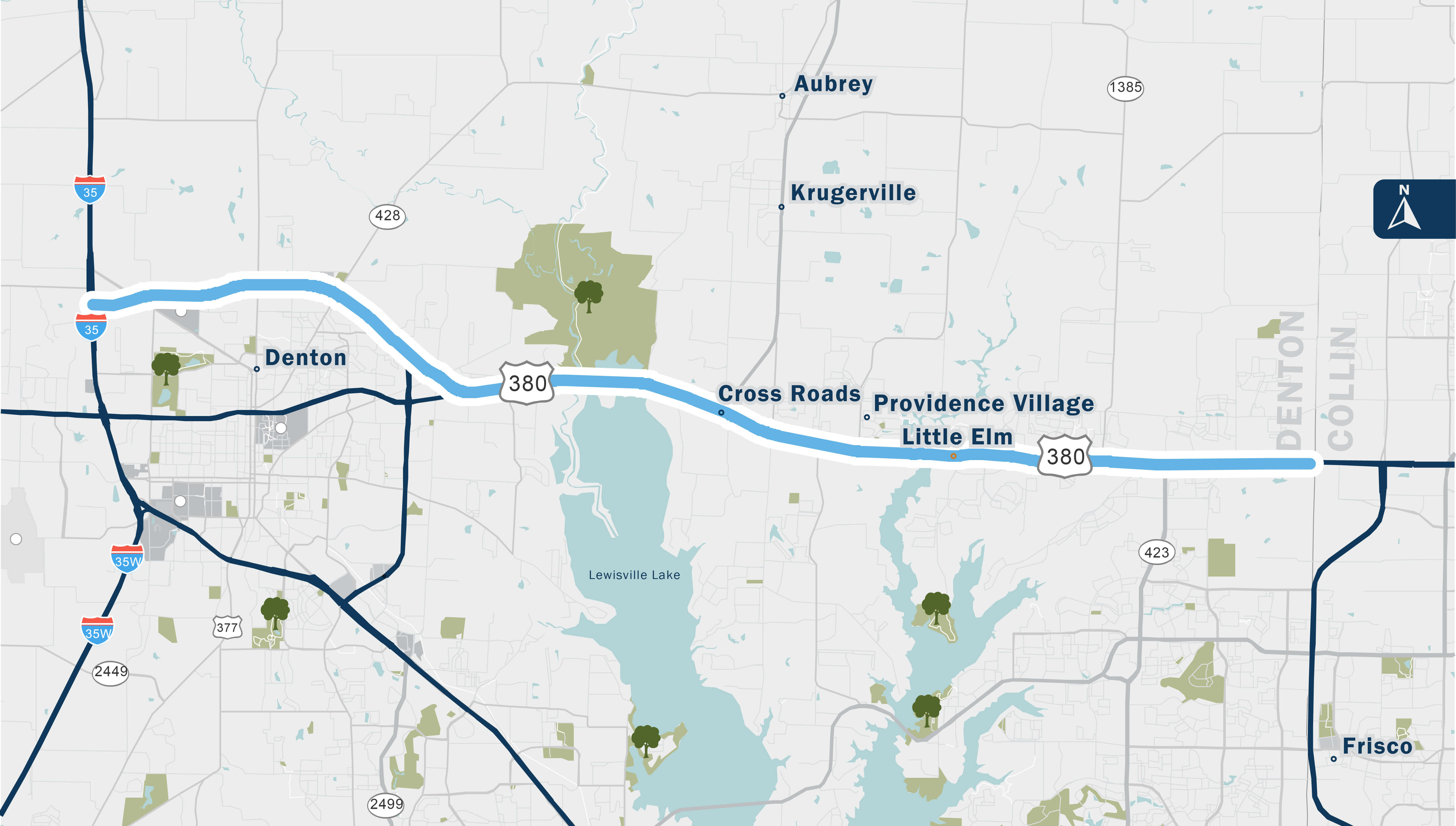
Study Location
The US 380 Denton County Feasibility Study limits include US 380 from I-35 to the Collin County Line. The study area includes the area north and south of US 380 and includes the Cities of Denton, Providence Village, Frisco, Little Elm, Aubrey, Krugerville, and Celina, and the Towns of Prosper and Cross Roads.
Click the study area and regional connectivity map images to enlarge.
Study Goals and Objectives
The study is anticipated to recommend a solution that has both regional and local benefits.

Regional
- Provide regional connectivity by providing an East-West connection serving Collin and Denton Counties
- Further enhance safety as the region grows

Local
- Provide reliable travel time and minimize congestion
- Enhance driver expectations
- Minimize human and environmental impacts
- Provide roadway network reliability
Study Area Map
Regional Connectivity Map
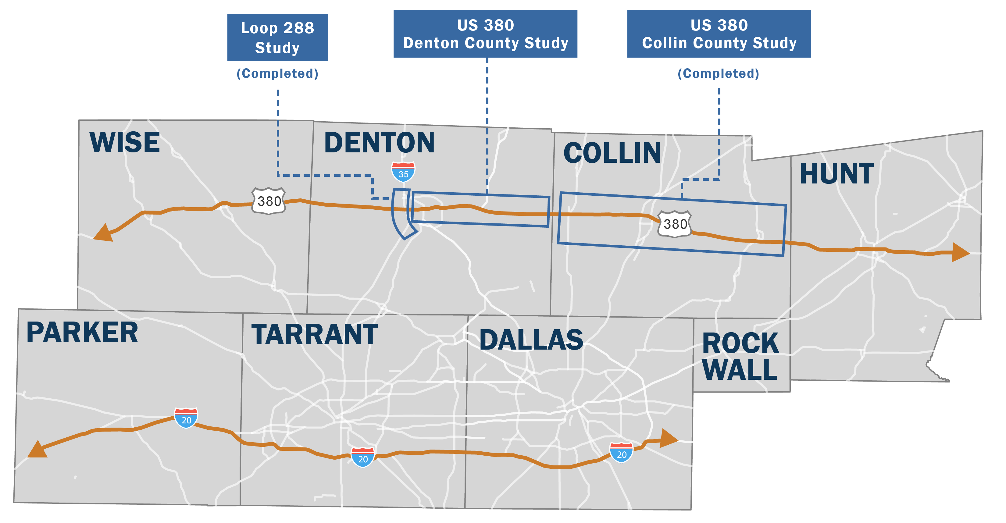
US 380 provides vital connectivity between Collin and Denton counties, similar to I-20 for Dallas and Tarrant counties. Currently, three major studies are working together to improve this connectivity. US 380 Denton County Feasibility Study and two recently completed studies: the Loop 288 Study in Denton County and the US 380 Collin County Feasibility Study.
Change in Study Area
Over 20,000 acres of farmland, ranch land, timberland, and vacant land has been converted to single family or commercial use in the study area between 2015 and 2021.

Study Area City Sizes for Comparison
| Denton | 63,000 acres |
|---|---|
| Little Elm | 14,000 acres |
| Frisco | 44,000 acres |
| Prosper | 16,000 acres |
| Celina | 20,000 acres |
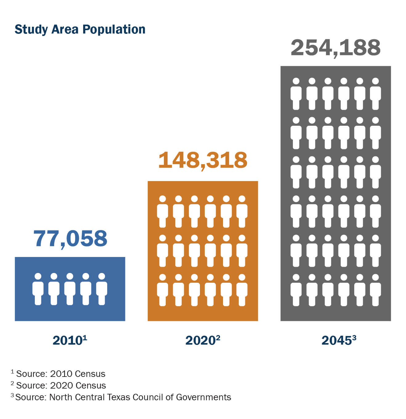
Study Area Population Growth
Population in the Study Area has grown 92% from 2010 to 2020 and is expected to continue to rise at a rapid pace. According to the North Central Texas Council of Governments (NCTCOG), the projected population in this study area for 2045 is 254,188.
Traffic
With a population that is only projected to increase in the near and long-term future, additional pressure will be placed on roadways in Collin and Denton counties.
Right now US 380 does not have the capacity to meet the current demand of roadway users, leading to greater congestion and unsafe conditions.
*Capacity is defined as the maximum number of vehicles a facility can handle before reaching failing Level of Service
**Demand is defined as the number of users that want to travel from one point to another
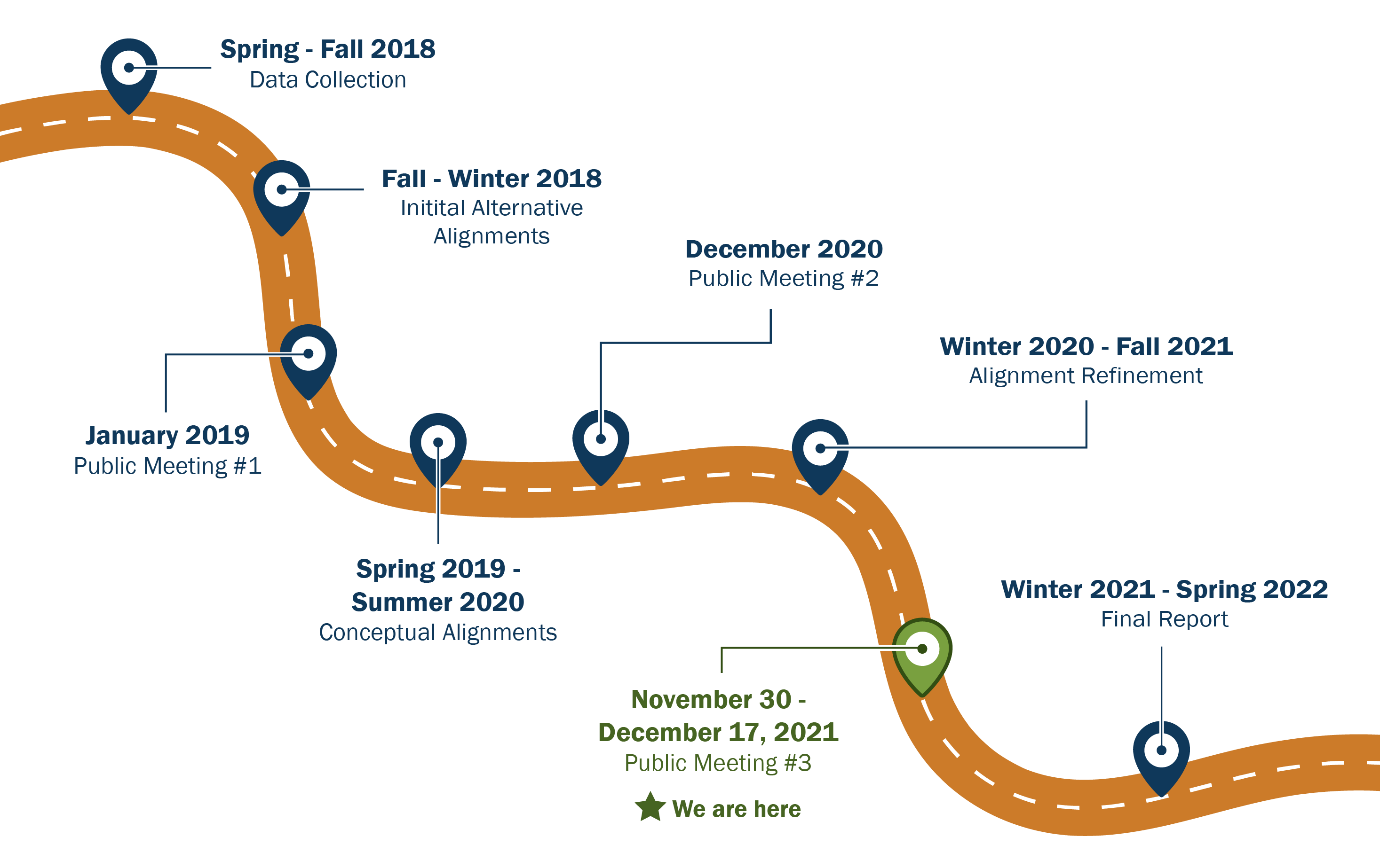
Study Timeline
Since fall 2018, TxDOT has engaged the public on the US 380 Denton County Feasibility Study, collecting feedback and adjusting planning based on public input. This virtual public meeting is the third, and last, public meeting on the US 380 Denton County Feasibility Study.
Click the timeline graphic to enlarge.
Review summary information from two public meetings below.
- Public Meeting #1 – January 2019
- Public Meeting #2 – December 2020
Public Meeting #1 Feedback
The public provided input on their concerns about the existing US 380 alignments as well as potential improvements. Based on survey feedback, individuals expressed congestion and safety were of greatest concern. 51% of individuals felt improving the existing US 380 was the best solution for the area. Lastly, when presented with proposed alignments, 30% favored the existing alignment, and 14% believed the solution was north of the existing alignment. 28% of respondents were not sure what the best solution for the study area is. Using this feedback, TxDOT expanded the study limits north to evaluate additional east to west corridors such as the Outer Loop corridor and screen proposed alignments for public meeting #2.
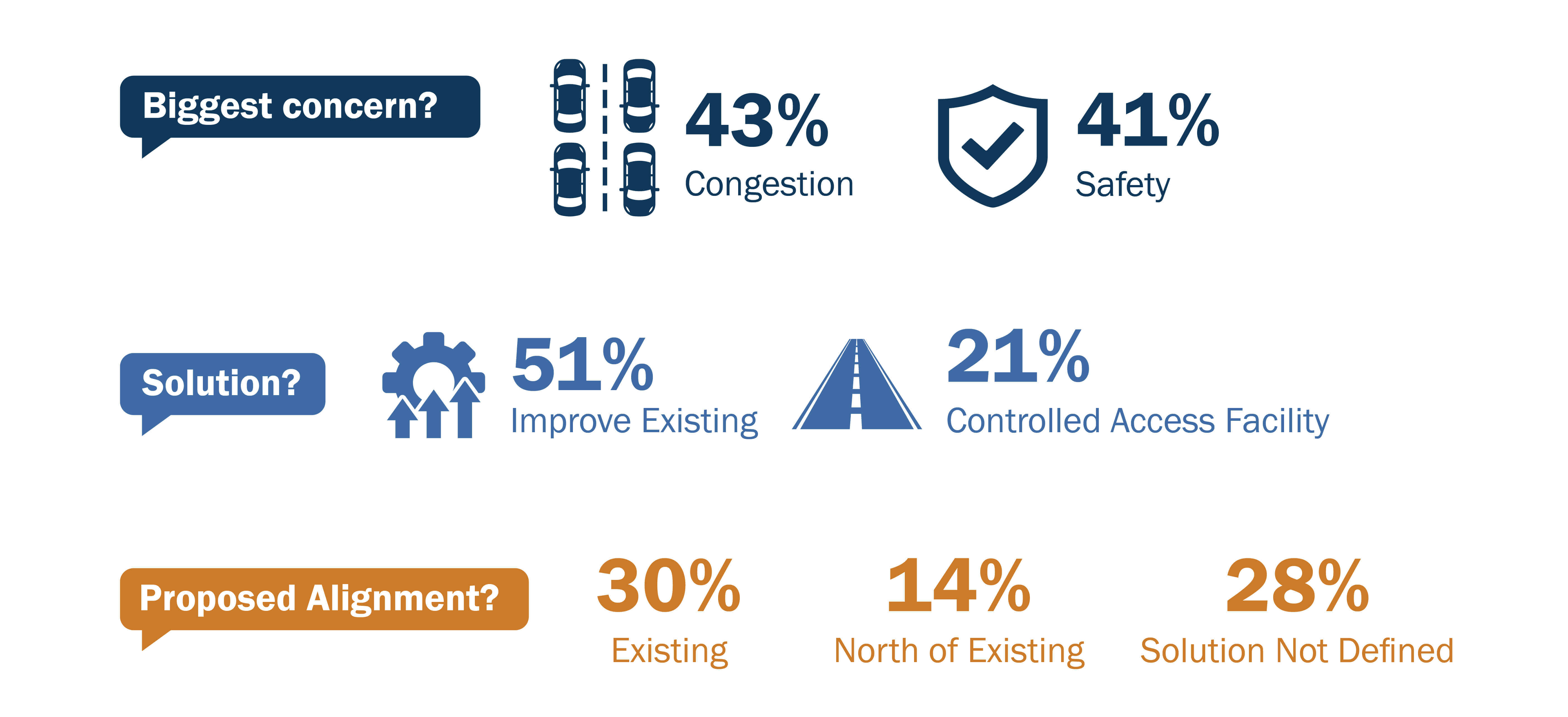
Click the images above to enlarge.
Public Meeting #2 Feedback
The public provided input on the draft conceptual alignments that were presented in the virtual public meeting. Over 400 surveys and over 300 comments were received during the public comment period. Of the 400 survey responses, 72% preferred the blue alignment. Regarding the public’s priorities for the project, minimizing human and environmental impacts, congestion, and safety were the three top priorities. And lastly, 68% of survey responses recognized the need for two freeways for the study area and 30% consider the Blue and Teal conceptual alignments the most necessary.
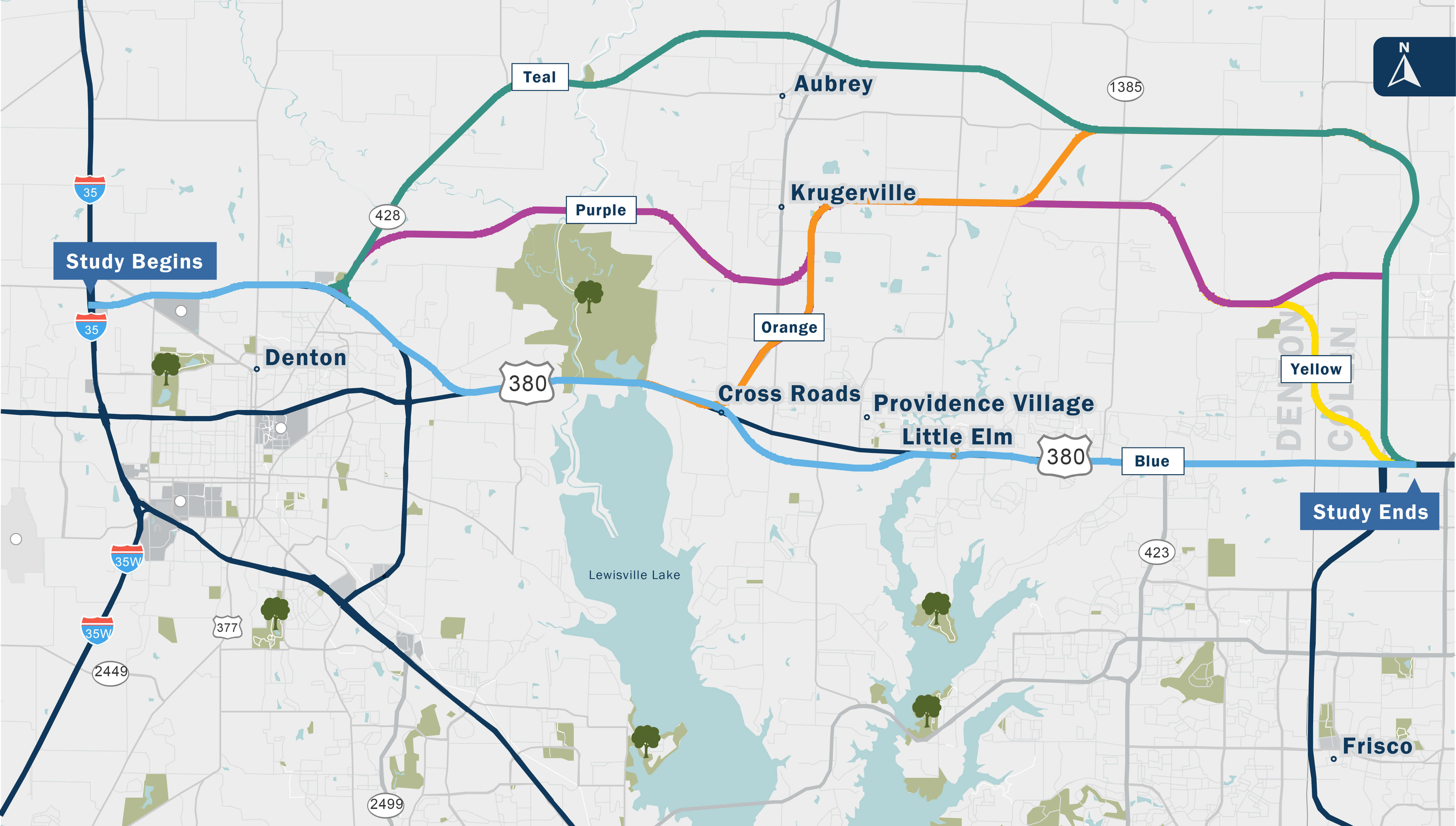
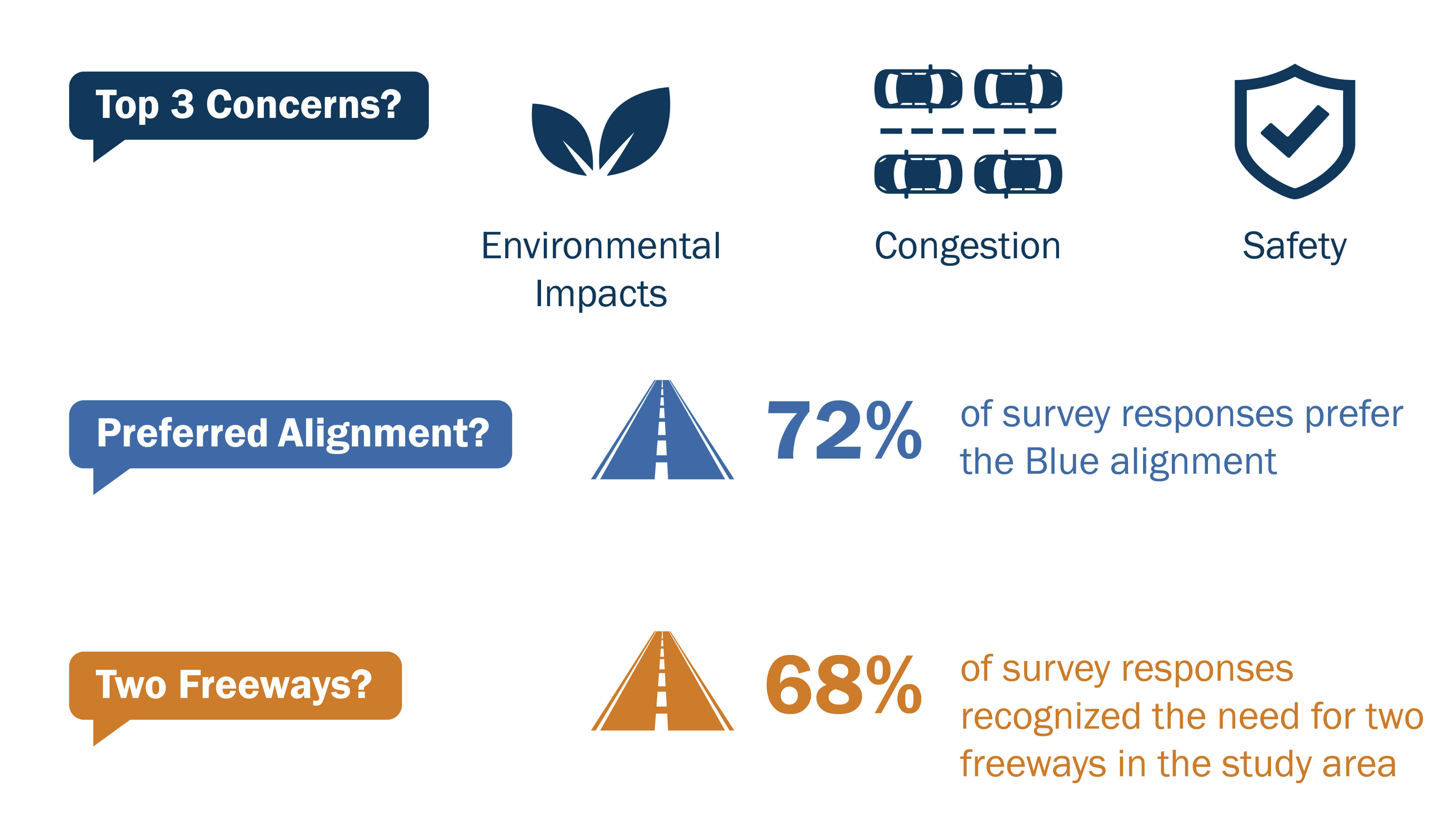
Click the images above to enlarge.
Evaluation of Alternatives
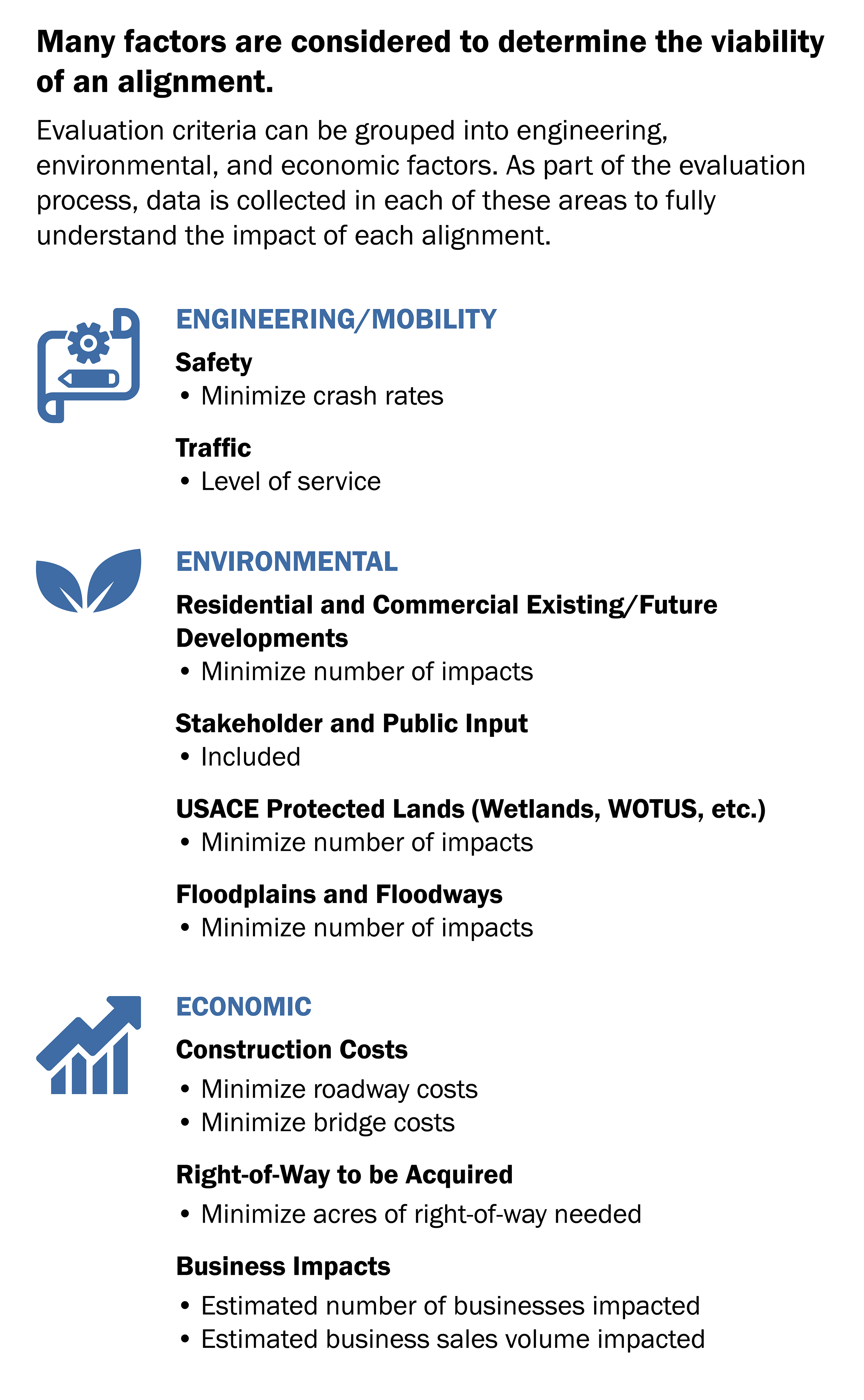
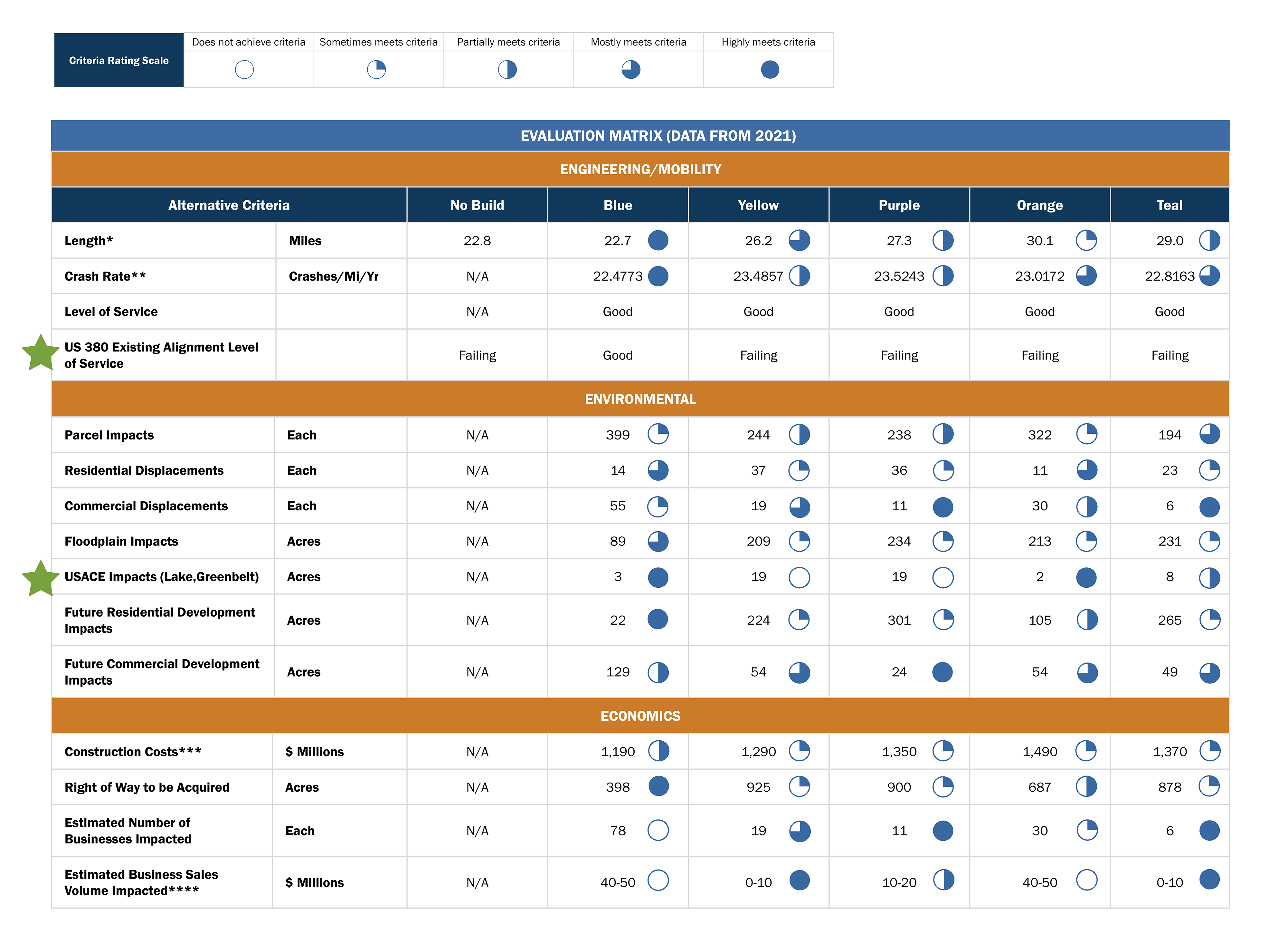
Evaluation Criteria
This table summarizes the data and feedback received in Public Meeting #2 and includes an overall rating on how well each alternative addresses the study’s criteria and/or goals and objectives. The symbols you see illustrate how well each alternative addressed the overall category’s criteria. The filled circle indicates that the alternative highly meets the criteria and the empty circle indicates that the alternative did not meet the criteria. For simplicity, the more filled the circle the better the alternative did. With that said, the Blue alternative achieved the highest rating and therefore it is TxDOT’s recommended alignment for US 380.
Unique to this study’s findings, TxDOT is also recommending that the Teal alternative be recommended for future study as it will play an important role in serving future developments north of US 380 within Denton and Collin Counties. For the purposes of this Public Meeting and for the US 380 Corridor, the remaining contents of this presentation will be focused on the US 380 recommended alignment, the Blue alternative.

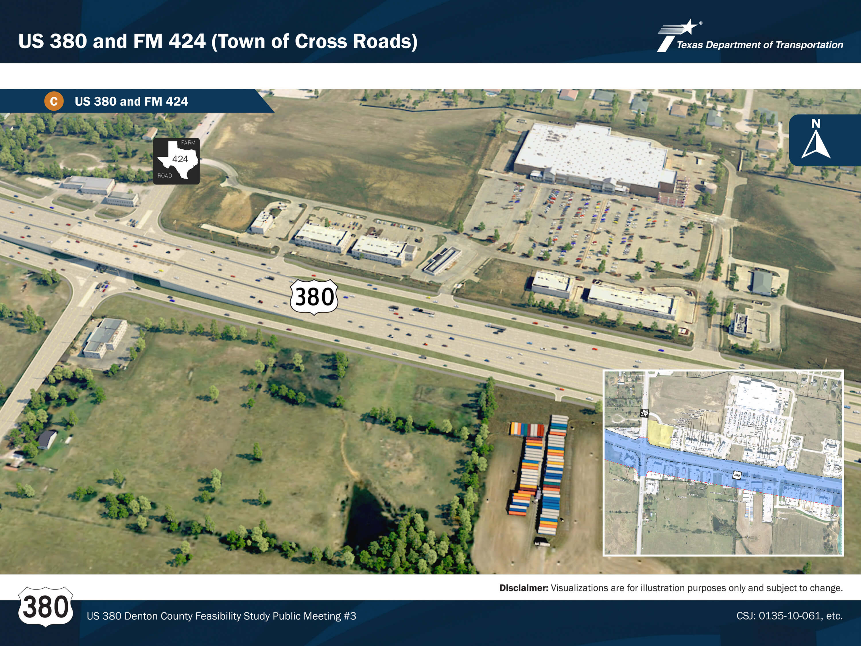
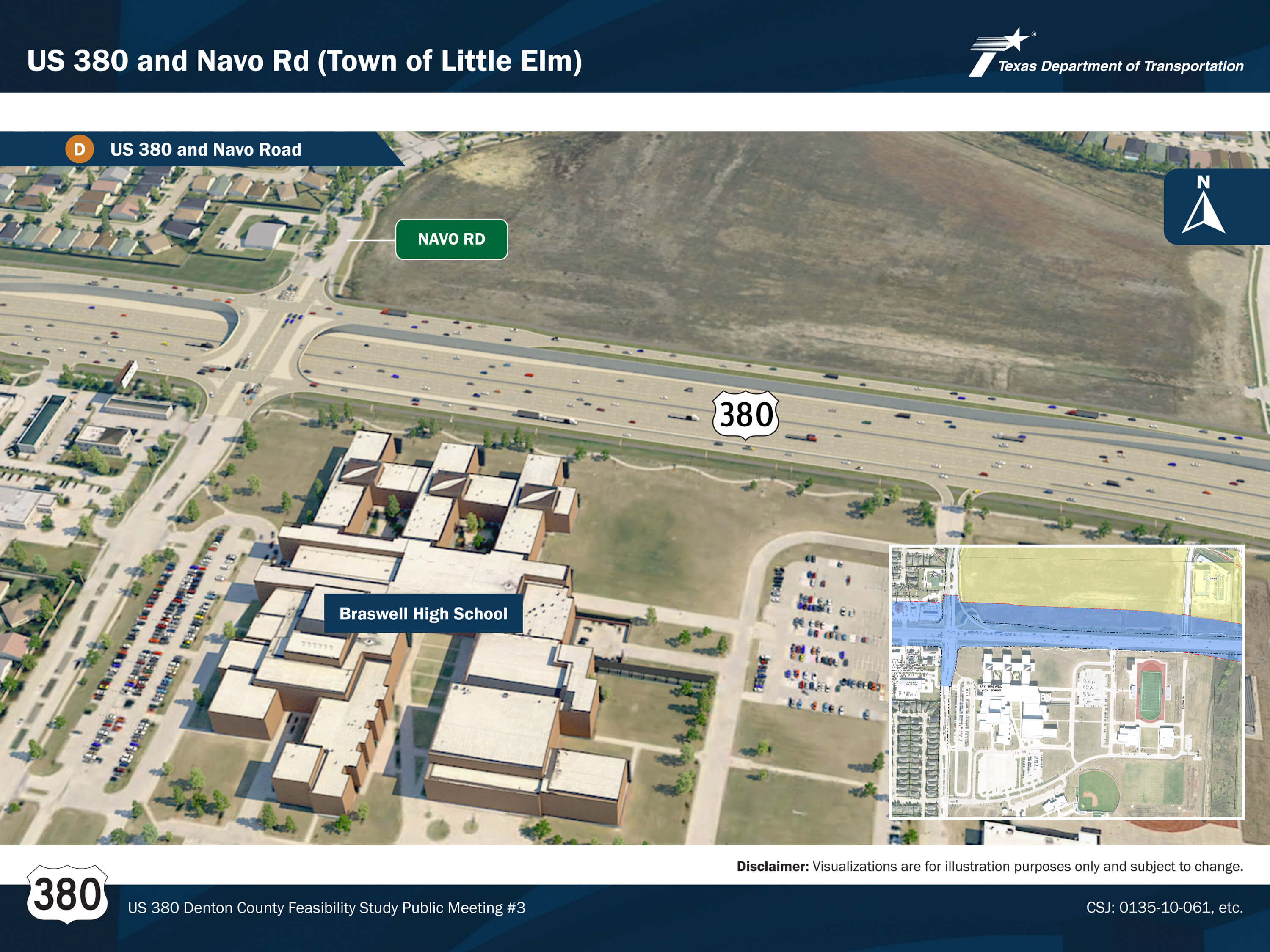
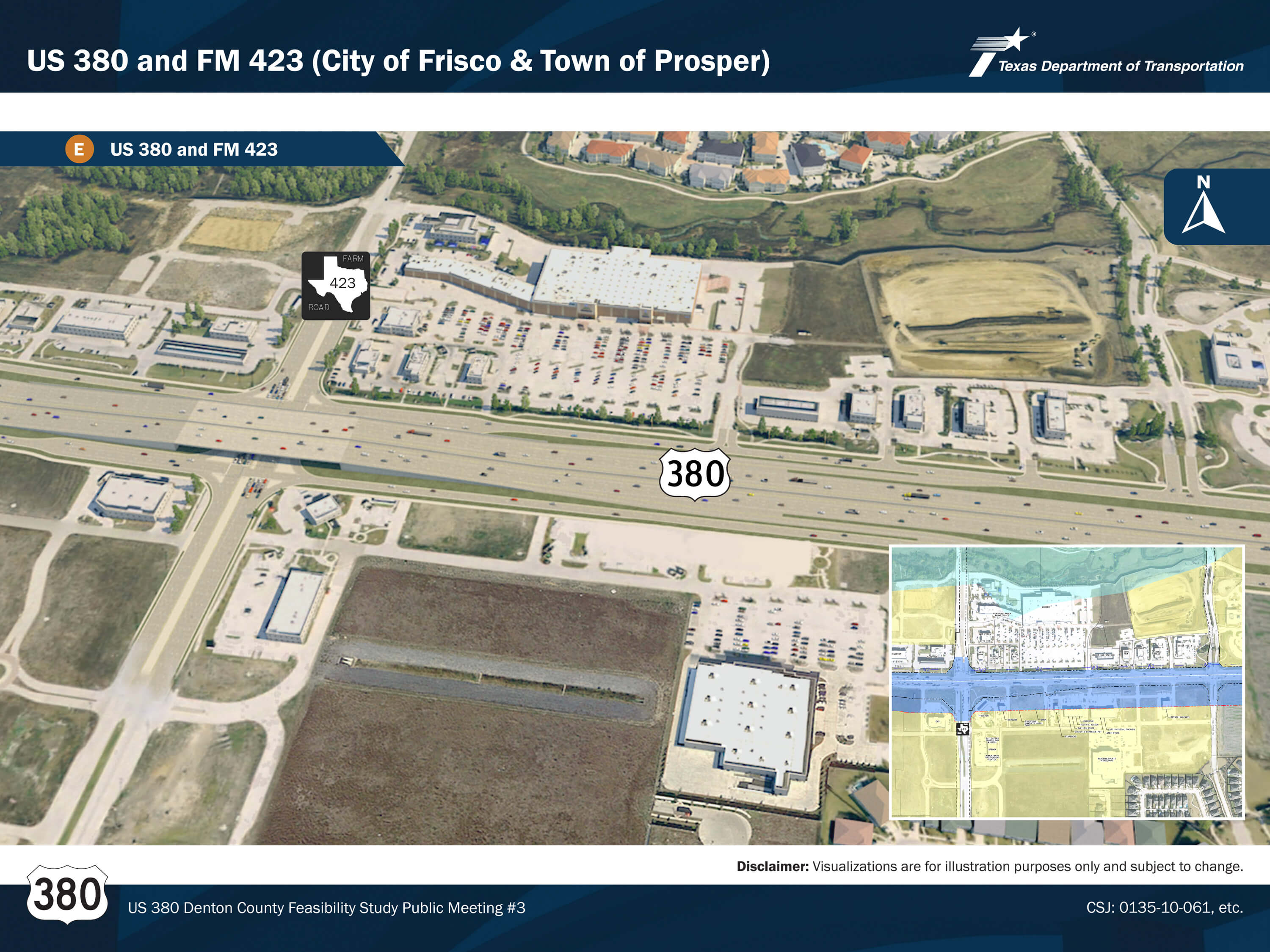
Click the images above to enlarge.
Conceptual Alignments and Study Recommendations
Study Recommendations
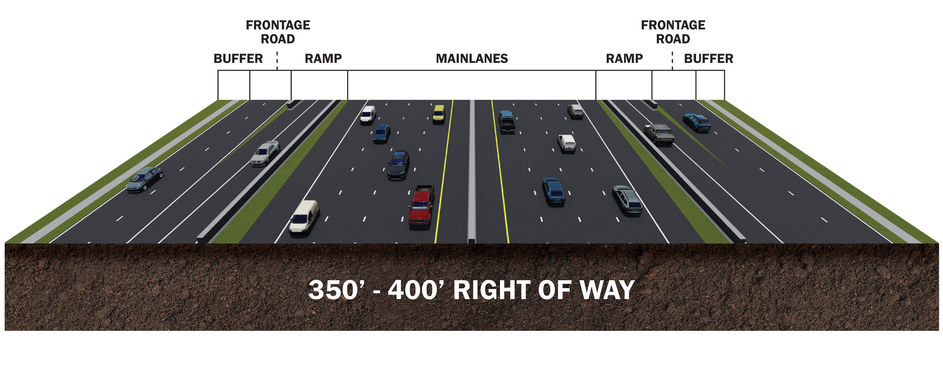
The map shown illustrates the recommended blue alignment from IH 35 to the Denton/Collin County line. TxDOT will seek to provide a freeway corridor consisting of 6-8 mainlanes and 4-6 frontage road lanes which is anticipated to accommodate 2045 travel demand. Furthermore, the freeway is anticipated to reduce crash rates. Overall, the anticipated total right of way width will vary in areas but is likely to be between 350’-400’.
Proposed Roadway Typical Section – Controlled Access Freeway
- 6-8 mainlanes and 4-6 frontage road lanes
- Accommodates 2045 travel demand volume forecast with acceptable level of service
- Enhanced safety and limited access
- 350’-400’ right-of-way footprint
Click the images above to enlarge.
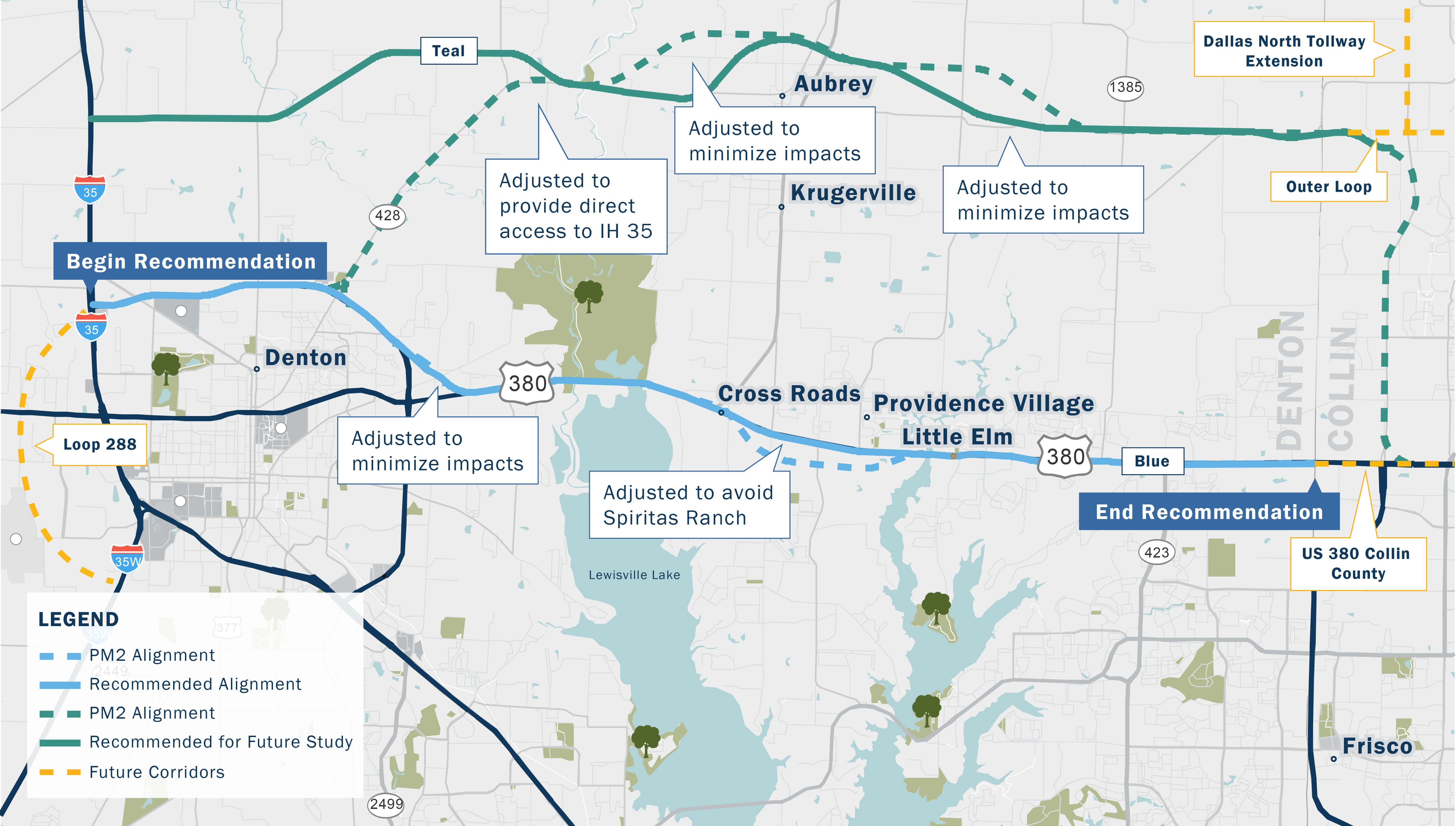
Adjustments from Previous Alignments and Further Evaluation
Based on public input from public meeting #2, adjustments to the alignments were made and are represented in the map shown. The dotted lines represent public meeting #2 alignments, and the solid lines represent the study primary recommendation, the blue line, and the alignment recommended for further study, the teal line.
The teal alignment, based on public and local agency feedback, was adjusted to provide direct access to I-35 and minimize impacts to existing residences. Unique to this study’s findings, TxDOT is also recommending that the Teal alternative be recommended for future study as it will play an important role in serving future developments north of US 380 within Denton and Collin Counties.
The blue alignment, based on public feedback, was adjusted to avoid the developing Spiritas Ranch in Little Elm and minimize impacts in the US 380/Loop 288 connection. To reiterate, the US 380 recommended alignment is the solid blue alignment.
Click the images above to enlarge.
Key Factors for Decision
Many factors contributed to TxDOT’s recommendation, including estimated travel delay throughout Denton County. The table shown illustrates what annual hours of delay would be experienced if one of the alignments considered during public meeting number two were constructed. Due to the growth in the region, all build alternatives would significantly reduce regional delay, however the blue alignment would bring the most reduction of travel delays.
A key factor for TxDOT’s recommended alignment decision was the anticipated delay or forecasted congestion for the US 380 corridor. The table shown illustrates what delay or congestion currently exists along the corridor in the 2020 Existing row and what is anticipated by 2045 for different alternatives. As you can see in the 2045 In-Progress row, if no additional improvements are made along the corridor beyond the in-progress project, congestion is anticipated to increase over 200%, making it three times what was experienced in the year 2020.
Overall, you’ll notice that the Blue alternative significantly outperformed all other alternatives in the year 2045. The purple, yellow, orange, and teal alternatives were unable to effectively serve travel demand which is concentrated along the US 380 corridor due to the location of development and lack of nearby alternative routes.
Summary of US 380 Corridor Future (2045) Delay Comparison
| Alternatives | Annual Hours of Delay | Percent Increase in Congestion |
|---|---|---|
| 2020 (Existing)* | 1,346,500 | – |
| 2045 (In-Progress) | 4,073,000 | 202% |
| 2045 (Blue) | 1,513,700 | 12% |
| 2045 (Purple/Yellow) | 3,142,600 | 133% |
| 2045 (Orange)** | 2,899,500 | 115% |
| 2045 (Teal) | 2,899,500 | 115% |
Note: 2045 Delay hours were derived from alternative Travel Demand Model scenarios produced by NCTCOG. These models did not alter the demographics or trip tables from the approved Mobility 2045 Travel Demand Model.
*Existing is based on TTI’s 100 Most Congested Corridors
**Orange alternative delay hours were assumed to be similar to Teal alternative
Study of Regional (Study Area) Annual Delay Comparison
| Alternatives | Estimated Annual Delay (Hours) | Decrease in Annual Delay |
|---|---|---|
| 2045 (In-Progress) | 106,098,500 | N/A |
| 2045 (Blue) | 92,626,500 | 13% |
| 2045 (Purple/Yellow) | 96,244,400 | 9% |
| 2045 (Orange)* | 96,244,400 | 10% |
| 2045 (Teal) | 95,578,300 | 10% |
Note: 2045 Delay hours were derived from alternative Travel Demand Model scenarios produced by NCTCOG. These models did not alter the demographics or trip tables from the approved Mobility 2045 Travel Demand Model.
*Orange alternative delay hours were assumed to be similar to Teal alternative
Study Recommendation Visualizations
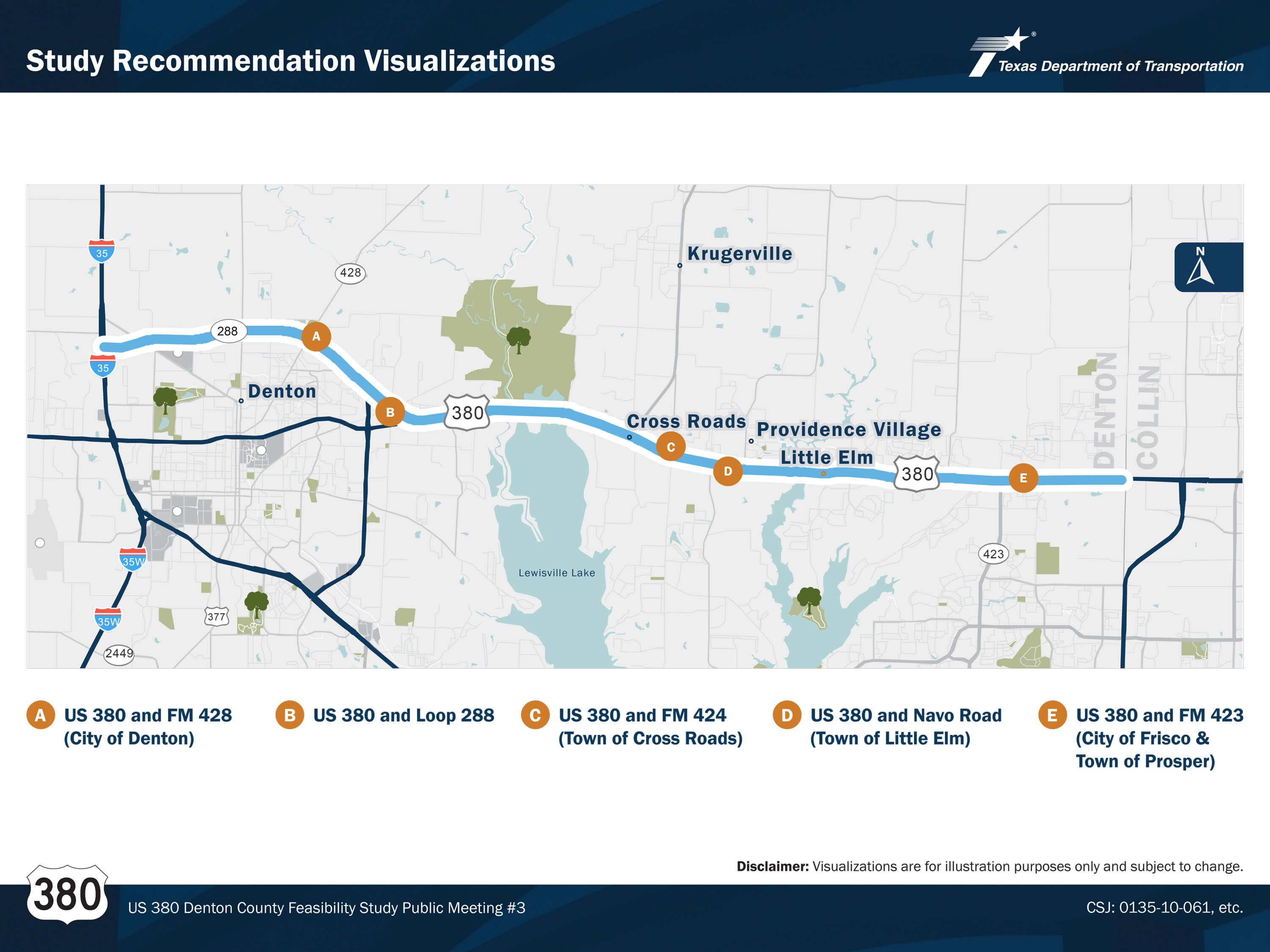
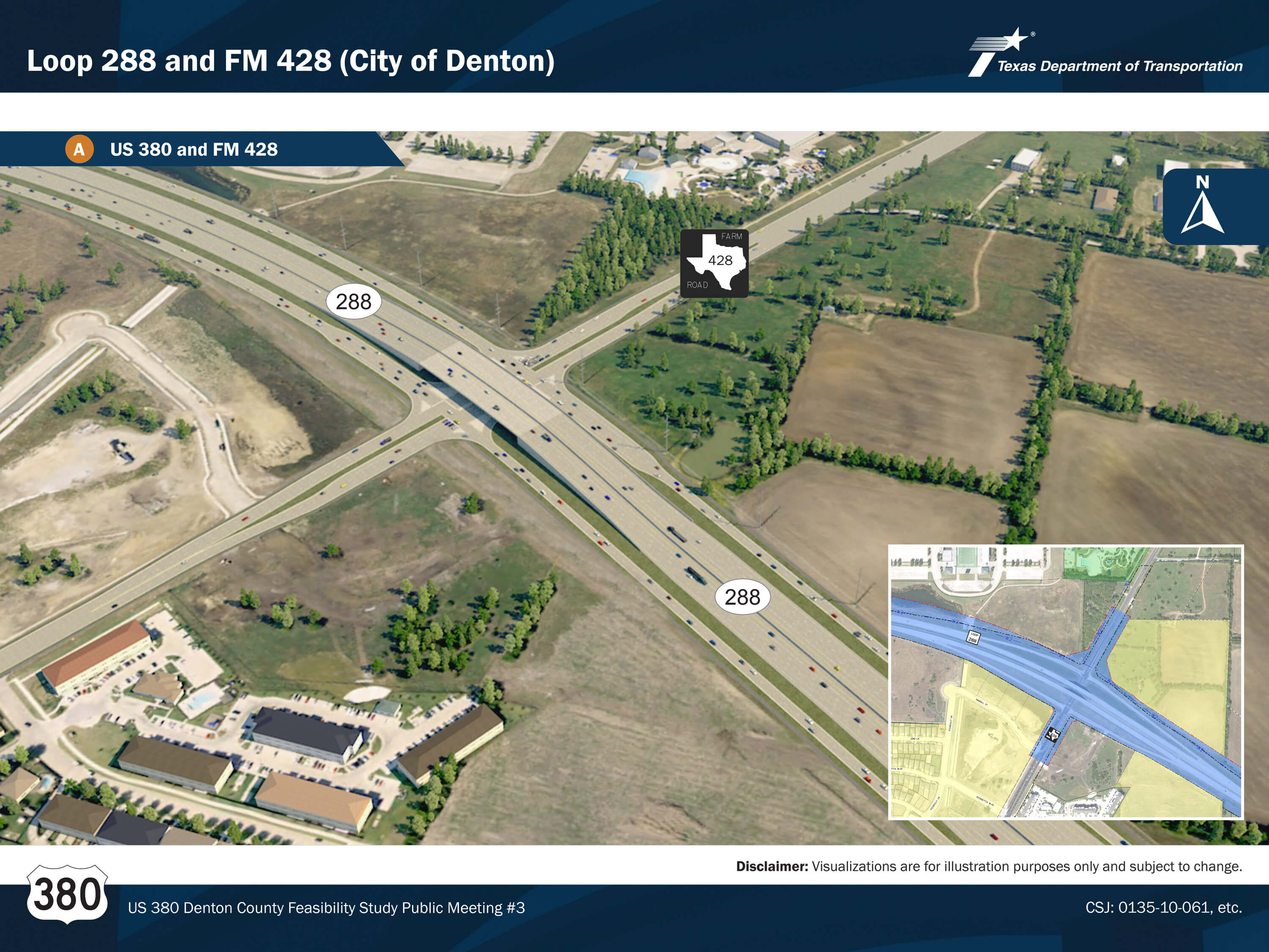
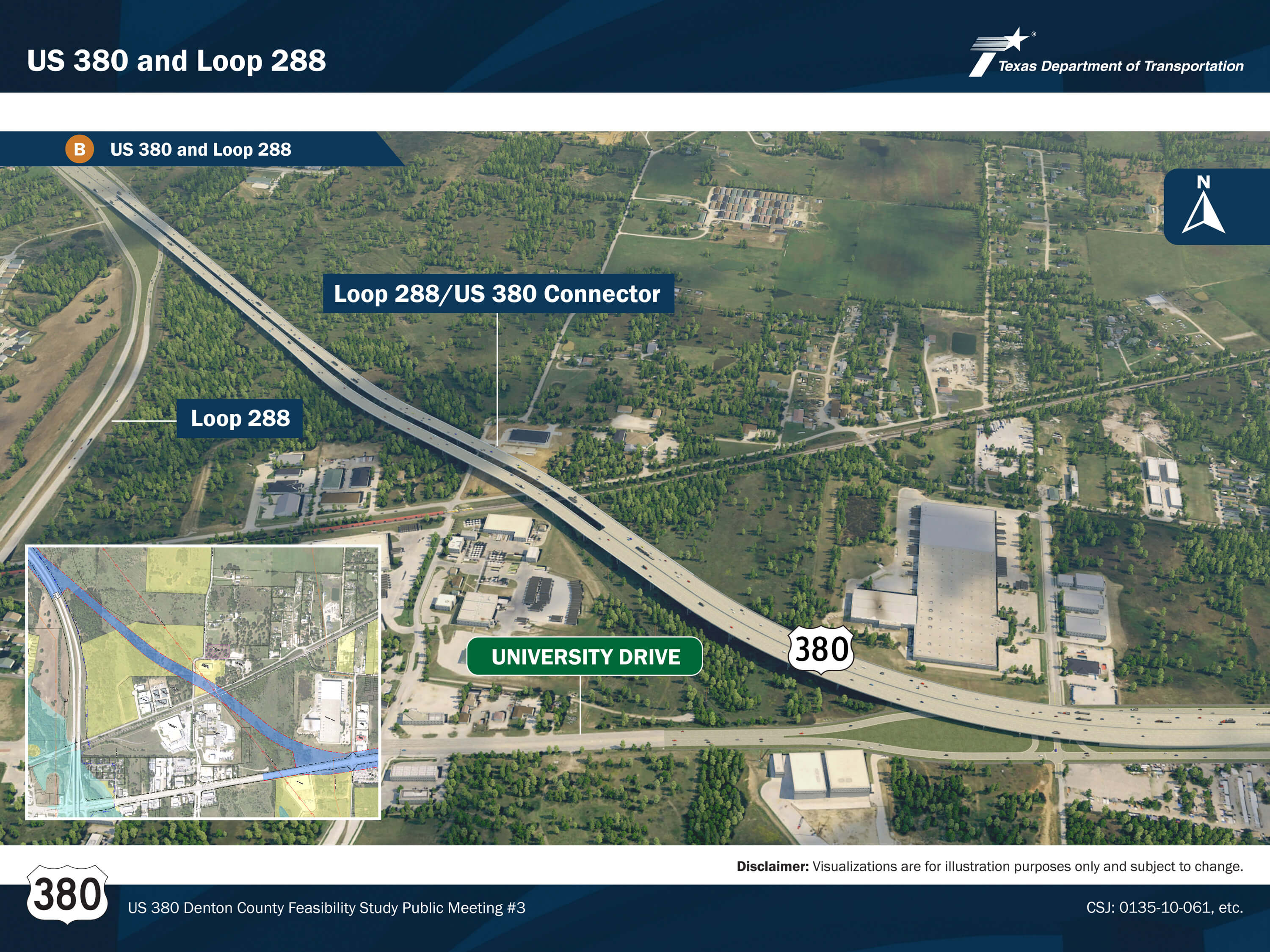
Click the images above to enlarge.
What’s Next?
Transition from Feasibility Study to NEPA Process
Once the Feasibility Study is completed in 2022, the next steps for this project are outlined here. Once the corridor is identified, it may be separated into independent projects which are prioritized based on need. The projects are then moved to the Environmental studies and schematic phase: in this phase, other viable alignments or changes to alignments can still be considered during environmental studies. Once the environmental study is complete, final design and construction plans are developed. Phased construction cannot begin until funding is identified.
The study recognized the urgency to acquire the necessary right of way for the improvements as soon as possible in order to minimize future displacements. Phased construction projects for this recommendation would likely include phasing of the US 380 and Loop 288 connection, the construction of frontage roads for Loop 288, and then ultimately the new freeway of US 380.
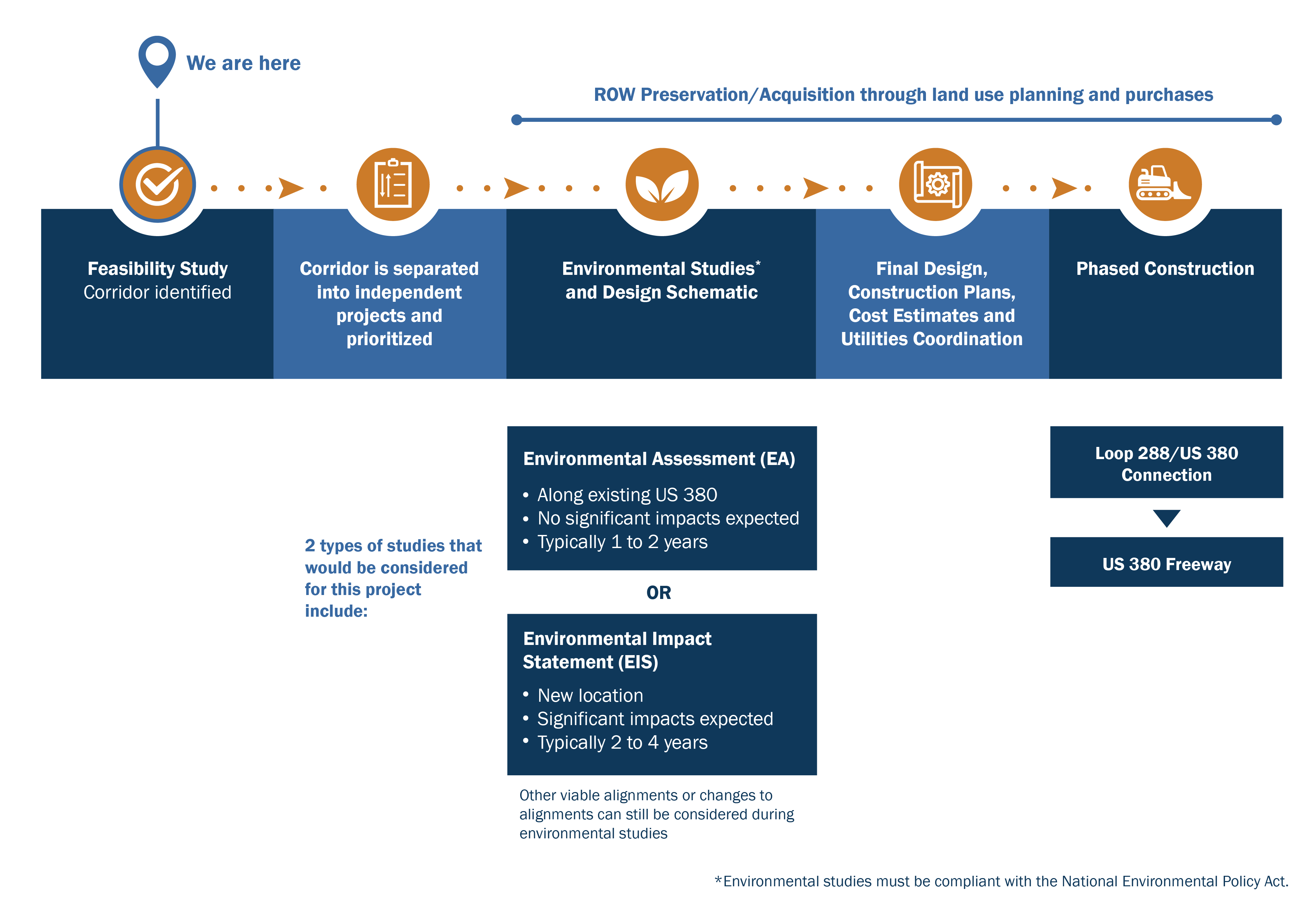
Click the image above to enlarge.
How to Submit Your Comments
Please submit your comments regarding the design modifications presented in this Public Meeting by using any of the four methods listed here by our deadline, January 19, 2022.
For general questions about the presentation or the project, please contact TxDOT Project Manager, Stephen Endres, P.E. at Stephen.Endres@txdot.gov.
Thank you!

We sincerely appreciate your participation and interest concerning the US 380 Denton County Feasibility Study. Your questions, comments, and concerns will receive careful consideration.

Online Comment
Click the provided link on this website in the top right corner


Mail-in Comments
TxDOT Dallas District Office
Attn: Stephen Endres, P.E.
4777 E. Highway 80
Mesquite, TX 75150

Leave a Voicemail
(833) 933-0439