Connecting Our City A safe connection between West Ashley & Downtown Charleston
Please participate in our online meeting by submitting your feedback in the Contact Form.
Project Overview
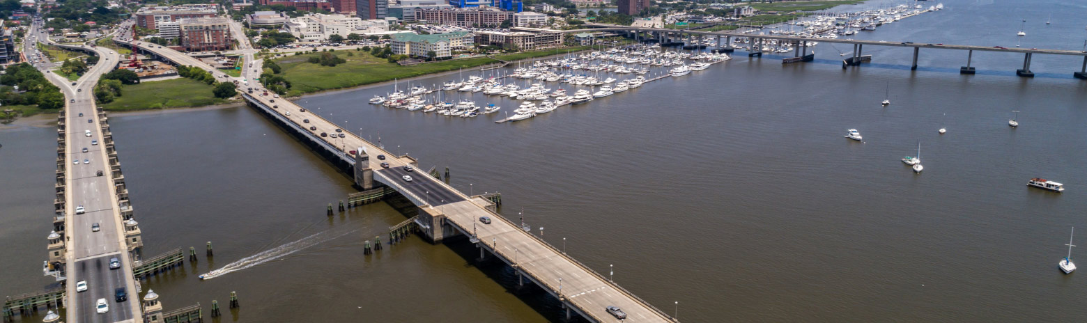
The Ashley River Crossing project is a bicycle and pedestrian bridge that will connect West Ashley and Downtown Charleston. The bridge will provide a safe connection between the West Ashley Greenway, Brittlebank Park and the Ashley River Walk.
Currently, the project is in the info gathering stage and designs have not yet been developed. Your feedback will play a role in informing the project team of design elements to consider. So, please take some time to leave your comments on the Contact Us page.
Purpose & Need
Why Do We Need A Bridge?Almost half of the City’s population resides in West Ashley, yet there is no safe pedestrian or bicycle connection between West Ashley and the peninsula. Connecting these areas will increase access to jobs, schools, and other amenities for area residents and visitors.
Expanding Existing Resources
The West Ashley area is known for its sense of community. Contributing to this community identity are neighborhood parks, farmers markets, and bike paths. These unique resources include:
-
The West Ashley Greenway
8.5 miles of multi-use recreational pathways
-
The West Ashley Bikeway
2.5 miles of paved bike paths connected to the East Coast Greenway Route
-
The East Coast Greenway Route
A 3,000-mile route of urban trails running from Maine into Florida
About the Project
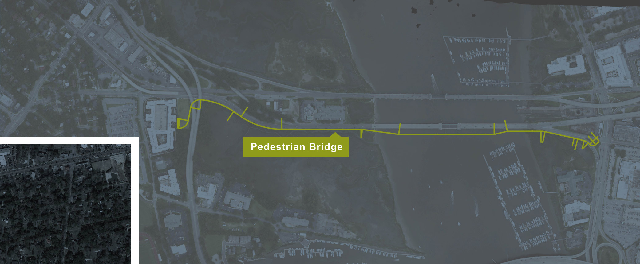
The Ashley River Crossing is a separated bike path and stand-alone bridge that will enhance the connectivity of Charleston’s metro area. The Project will tie to the end of the West Ashley Greenway and connect to Downtown by a separated path and bridge across the Ashley River. In addition to the bridge, improvements will be made at key intersections along the West Ashley Greenway and at the Bee Street and Lockwood Drive intersection on the Peninsula. The project also include the improvements to the West Ashley Greenway crosswalk at Wappoo Road. This crossing is shown in the inset map below. Click the points on the map for more details:
West Ashley Greenway & Folly Rd Crosswalk
To create a more user friendly experience for the Greenway it is proposed to place a crosswalk to connect the Greenway across Folly Road. The existing Folly Road crosswalk at Windermere would be removed. This allows pedestrians and bicyclists using the Greenway to cross Folly Road in a protected, single stage movement, improving safety and convenience for users of the Greenway.
In accordance with federal law protecting publicly owned recreation areas, the City is soliciting comments on the effects this project would have on the West Ashley Greenway tie in with Folly Road. A short segment of the Greenway will need to be widened to align with the proposed Folly Road crosswalk. It is anticipated that construction in this area will last up to one (1) month and would not result in any closures of the Greenway during construction. When completed, the condition of the Greenway will be equal to or better than existing conditions.
It is anticipated that construction of the project will meet the definition of a de minimis impact, as defined in 23 CFR 774.17(5).
Wappoo Rd Crosswalk
To improve usability of the Greenway, improvements to the Greenway crossing at Wappoo Road will include increased visibility of the crosswalk, high visibility ladder style markings to the crosswalk, and rapid rectangular flashing beacons may be used to replace the existing standard beacons.
Ashley River Crossing
From the West Ashley side, it is proposed to connect the path to the existing path on the back of 35 Folly Apartments. From there the path will cross through the City’s park property until it reaches the Ashley River marsh, where it is proposed to widen out the US 17 causeway to provide a 12’ wide path with safe space between the road and path. As the path proceeds toward the Ashley River, a bridge will cross the Ashley River approximately 50’ downstream from the US 17 bridge. A movable span will be placed at the navigational channel of the Ashley River. Once the bridge reaches the east side of the river, it will tie in close to the off ramp from US 17 as it approaches the intersection with Lockwood Drive and Bee Street.
Bee St & Lockwood Dr Intersection Improvements
In order to improve bicycle and pedestrian safety approaching the Lockwood Drive/Bee Street intersection from the west, it is proposed to move the free flowing right turn from US 17 to Lockwood Drive closer to the intersection with Bee Street, and signalizing the right turn to provide a protected pedestrian crossing. Additional improvements along Bee Street are being considered.
Project Benefits
The Ashley River Crossing will provide a wide range of benefits to the community, including:
-
Safety
Bicyclists and pedestrians will no longer have to share the roadway with vehicles
-
Sustainability
The project is an eco-friendly travel option
-
Connection
Increased access to jobs, schools, and amenities
Environmental Studies For The Project Required by NEPA
-
Historic Structures & Archaelogical Resources
Historic Structures & Archaelogical Resources Under Section 106 of the National Historic Preservation Act, federally funded projects must consider impacts on historic architecture and archaeological resources. Based on field reviews, while previously recorded sites were found near the project area, the project is not anticipated to impact any historic structures or archaeological resources. Coordination with the State Historic Preservation Office (SHPO) is ongoing.
-
Wetlands & Tidal Areas
Wetlands & Tidal Areas The US Army Corps of Engineers (USACE) regulates Waters of the US under the regulatory authority of Section 404 of the Clean Water Act (CWA). Under state statutory provisions and regulations, SC Department of Health and Environmental Control Office of Coastal Resource Management (SCDHEC-OCRM) regulates impacts to tidal areas, also known as critical area, which are the coastal waters, tidelands and beach systems along the Atlantic Ocean. Critical area has been identified in the study area. Construction of the project will impact minor amounts of wetlands and critical area (less than 0.3 acres), which will require a Nationwide Permit from USACE and Critical Area Permit from SCDHEC-OCRM.
-
Threatened & Endangered Species
Threatened & Endangered Species Pursuant to Section 7 of the Endangered Species Act (ESA) of 1973, the project study area was evaluated for the potential presence of any federally protected species currently listed for Charleston County. Suitable habitat was identified within the project study area for American wood stork, bald eagle, Eastern black rail, red knot, Atlantic and shortnose sturgeons, giant manta ray, West Indian manatee, green sea turtle, hawksbill sea turtle, Kemp’s ridley sea turtle, leatherback sea turtle, and loggerhead sea turtle. Coordination with US Fish and Wildlife Service and NOAA-NMFS for potential impacts to threatened or endangered species is ongoing.
-
Hazardous Materials
Hazardous Materials A Limited Phase 1 Environmental Site Assessment was conducted to identify potential hazardous sites, underground storage tanks and/or other hazardous materials within the study area. One site with the potential for hazardous materials was identified near the study area. Construction is not expected to impact this site.
-
Essential Fish Habitat
Essential Fish Habitat Under the Magnuson-Stevens Fishery Conservation and Management Act (Magnuson-Stevens Act) of 1976 (as amended 1996), the study area was assessed for presence of essential fish habitat (EFH), which is defined as those waters and substrate necessary to fish for spawning, breeding, feeding, or growth to maturity. EFH was identified within the study area and potential projects impacts are being coordinated with National Oceanic and Atmospheric Administration – National Marine Fisheries Service (NOAA-NMFS).
-
Air Quality
Air Quality The U.S. Environmental Protection Agency (EPA) has established the National Ambient Air Quality Standards (NAAQS) for atmospheric pollutants that are considered harmful to public health and the environment in accordance with the Clean Air Act of 1970, amended (CAA). Charleston County is currently considered to be in attainment with all NAAQS standards. No action is required for the project.
-
Community Impacts & Benefits
Community Impacts & Benefits In accordance with Executive Order (EO) 12898 (Federal Actions to Address Environmental Justice in Minority Populations and Low-Income Populations) and FHWA guidance on Community Impact Assessment, the project is being assessed for impacts and benefits to the surrounding communities. The project is expected to be largely beneficial for surrounding communities by providing a safe bicycle and pedestrian connection between West Ashley and downtown Charleston.
-
Parks & Recreation Facilities
Parks & Recreation Facilities The West Ashley Greenway is located within the proposed study area. As a part of the project, improvements to bicycle and pedestrian access will be made at several intersections in the area to provide safe connections between the Greenway and the proposed project.
In accordance with federal law protecting publicly owned recreation areas, the City is soliciting comments on the effects this project would have on the West Ashley Greenway tie in with Folly Road. A short segment of the Greenway will need to be widened to align with the proposed Folly Road crosswalk. It is anticipated that construction in this area will last up to one (1) month and would not result in any closures of the Greenway during construction. When completed, the condition of the Greenway will be equal to or better than existing conditions.
It is anticipated that construction of the project will meet the definition of a de minimis impact, as defined in 23 CFR 774.17(5). -
Relocations & Right Of Way Acquisition
Relocations & Right Of Way Acquisition The proposed project will be constructed within SCDOT and/or City of Charleston rights of way. No relocations are anticipated as a result of the project.
Design-Build Procurement
The City intends to award the final design and construction of the project to a Design-build team. In Design-build procurement the project owner awards a single contract to provide both design and construction services. In this method of project delivery, contractors and consultant design firms form a single team and take on the responsibility for both design and construction.
Design-build allows engineers and contractors the potential opportunity to introduce innovative design and construction alternatives that are equal or better than the contract requirements while still meeting all other contract requirements. It also allows contractors to utilize specialized construction means and methods. Design-build allows the overlap of design, permitting and construction activities, which can often result in faster project delivery.
Project Funding
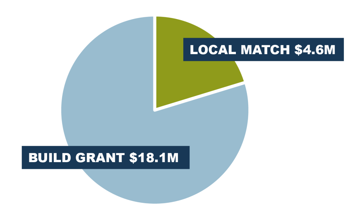
In July 2019, the City of Charleston applied for The Better Utilizing Investments to Leverage Development (BUILD) Transportation Discretionary Grant. This federal grant program has awarded $7.1 billion to 554 projects in the last ten years. In November 2019, the project was awarded the full requested amount of $18.1 million. A local match of $4.6 million for the project will come from the City of Charleston, Charleston County, and the Medical University of South Carolina.
Project Timeline
-
November 2019
City of Charleston Receives BUILD GrantView the BUILD Grant Application on the project website
-
September 2020
Project Launch -
Fall 2020 - Winter 2021
Field Studies and Data Collection -
Winter - Spring 2021
Conceptual Design Studies and Environmental Documentation -
Spring 2021
Public Meeting We Are Here -
Summer 2021
Environmental Document Approval -
Summer - Fall 2021
Design Build Procurement -
Winter 2022
Award Design Build Contract -
2022 & Beyond
Final Design and Construction
Get In Touch
Thank you for your interest in the Ashley River Crossing Project! We want to hear from you.
Please use the form below to share your thoughts and offer your feedback. The public comment period ends on May 17, 2021.
Submit Comments
Comments may be submitted to the project team by way of:
Project Website:
Project Email:
Terri Sciarro at info@ashleyrivercrossing.com
Standard Mail:
823 Meeting Street
Charleston, SC 29403
Contact Form
Thank you for your interest, the comment period for the Ashley River Crossing project has closed. If you would like to stay in touch, please send a request to info@ashleyrivercrossing.com and we will keep you informed with the projects progress.
Join Our Mailing List
Stay up to date on the project by filling out the form below.


Project Contact Information
City of Charleston Project Contact
Terri Hubbard Sciarro,
Senior Construction Project Manager
City of Charleston | Capital Projects Department of Parks
823 Meeting St.
Charleston, SC, 29403
(843) 724-7191
capitalprojects@charleston-sc.gov