Welcome to the City of Brampton LRT Virtual Open House
Don’t want to sign in? Close this window and proceed to the virtual open house.


Welcome to the City of Brampton LRT Extension Study Virtual Open House 2
Welcome to the 2nd virtual Open House for the Brampton LRT Extension Project. In today’s virtual open house, we will share:
- an update on the study since the last virtual open house in Summer 2020,
- the findings of the evaluation of the short list LRT options, and
- a summary of the emerging preferred options.
We are looking for input on the two emerging preferred options — scroll through the materials to learn more about the options and to provide your feedback.
Project Overview
Extending the planned Hurontario LRT from the Brampton Gateway Terminal at Steeles Avenue to the Brampton GO station is a key transit priority and city-building project for the City of Brampton.
Much more than a way to get from A to B, this LRT project will play an important role in the long-term rapid transit network in Brampton and is essential for supporting the sustainable growth and evolution of the Downtown Core and Central Area.
Vision Statement
The LRT Extension will contribute to a safer and more integrated transportation system to serve the City of Brampton, encouraging civic sustainability, emphasizing transit use and other modes of transportation over traditional automobiles, and supporting the revitalization of Downtown Brampton into an aesthetically beautiful, place-making destination. The vision for the LRT Extension reflects the transportation vision and actions set out in the Brampton 2040 Vision (2018).
Goals
- Strong Connections
- Complete Travel Experiences
- Sustainable and Healthy Communities


Problem Statement
The extension of the Hurontario LRT from Steeles Avenue to Brampton GO is intended to address the growth-related transportation needs in the study area and the City of Brampton.
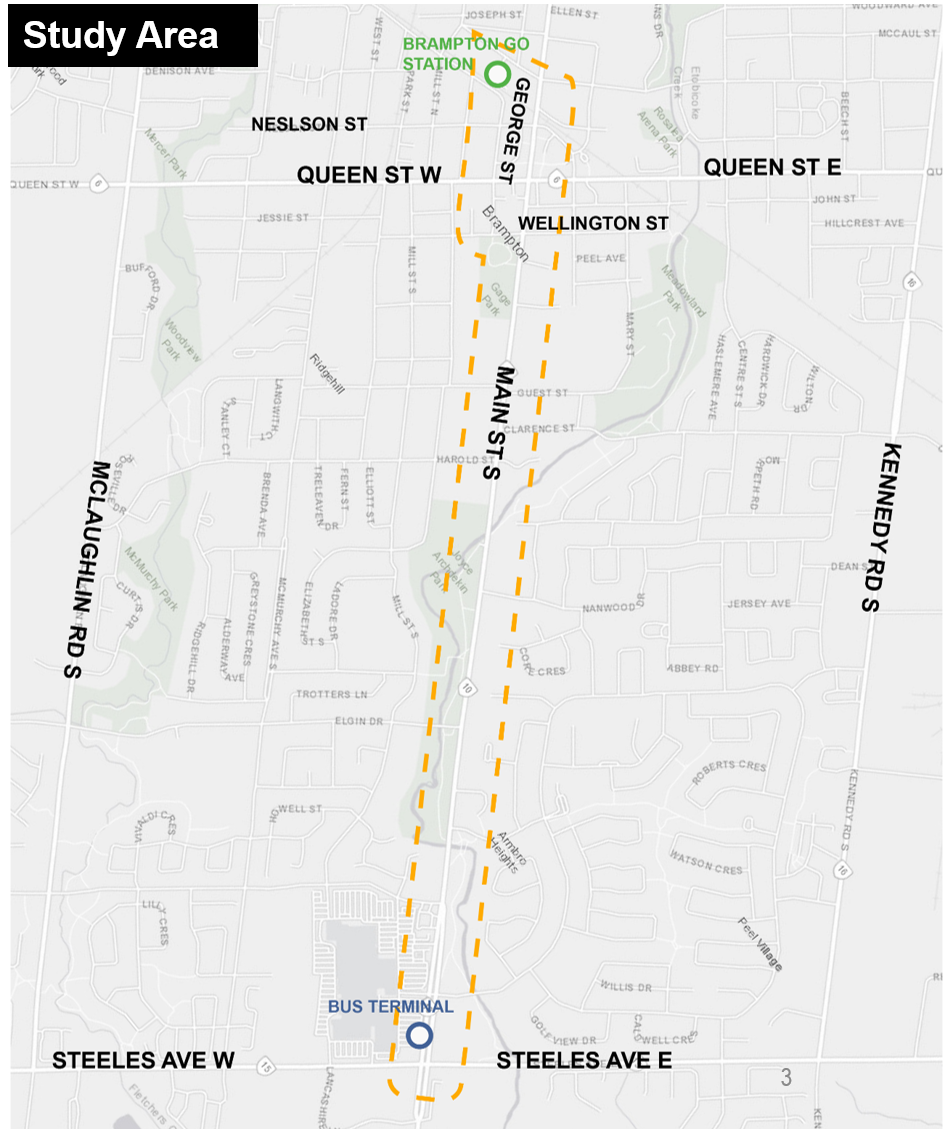
In the Study Area...
- Population is expected to increase by over 26,000 by 2041
- Employment is expected to increase by over 13,000 by 2041
- To meet the City’s growing transportation needs, transit service along Main Street would need to increase by 40%
- If no improvements are made, average trip times would increase by 5%


Source: City of Brampton (June 2019)
 Click on the image to enlarge.
What we Heard at Open House 1
In the Summer 2020 virtual Open House, we presented the long list of options. We received hundreds of comments from the public regarding the future of the LRT extension. Here are some frequently noted key messages.
Expedite the project
Minimize impacts to Main Street South and Downtown
Provide expess service with fewer stops
Create a transit hub at Brampton GO Station
Support businesses and revitalize Downtown
Retain heritage character and mature tree canopy on Main Street South
Provide a pedestrian friendly environment and ease of transfer between travel modes
Calm traffic along surrounding residential streets
Protect for future northward extension
Secure Provincial funding for the project
Study Process
The evaluation of options is a multi-level process that has occurred over the course of the study.
This flow chart is an overview of the study process. Through the three-level process, the long list of LRT options was evaluated and narrowed down to a short list. The short list was evaluated and is being presented at Virtual Open House 2.
The Transit Project Assessment Process (TPAP) is a provincial environmental assessment process developed specifically for the approval of public transit projects.
Proponents must complete the prescribed steps of the process within specified time frames.

Preliminary Design Business Case
The City of Brampton evaluated the short list options using the Metrolinx Business Case framework. A preliminary design business case (PDBC) was used to assess the seven (7) short-listed options.
The analysis was completed for four (4) business cases: Strategic, Economic, Financial, and Deliverability and Operations.
-
Strategic
How and why should the investment be pursued; based on goals, plans and policies?
-
Economic
What is the investment’s overall value to society?
-
Financial
What are the financial implications of delivering the investment?
-
Deliverability
What are the risks and requirement to consider to deliver and operate the investment?


Criteria:
Strong Connections
- Improve access to transit
- Increase access to economic opportunities
- Support city-building objectives
Complete Travel Experiences
- Improve travel time and level of service
- Improve comfort and safety
- Building an integrated transportation network
Sustainable and Healthy Communities
- Move people with less energy and pollution
- Improve quality of life and public health
- Reduce impacts to the natural and cultural environment
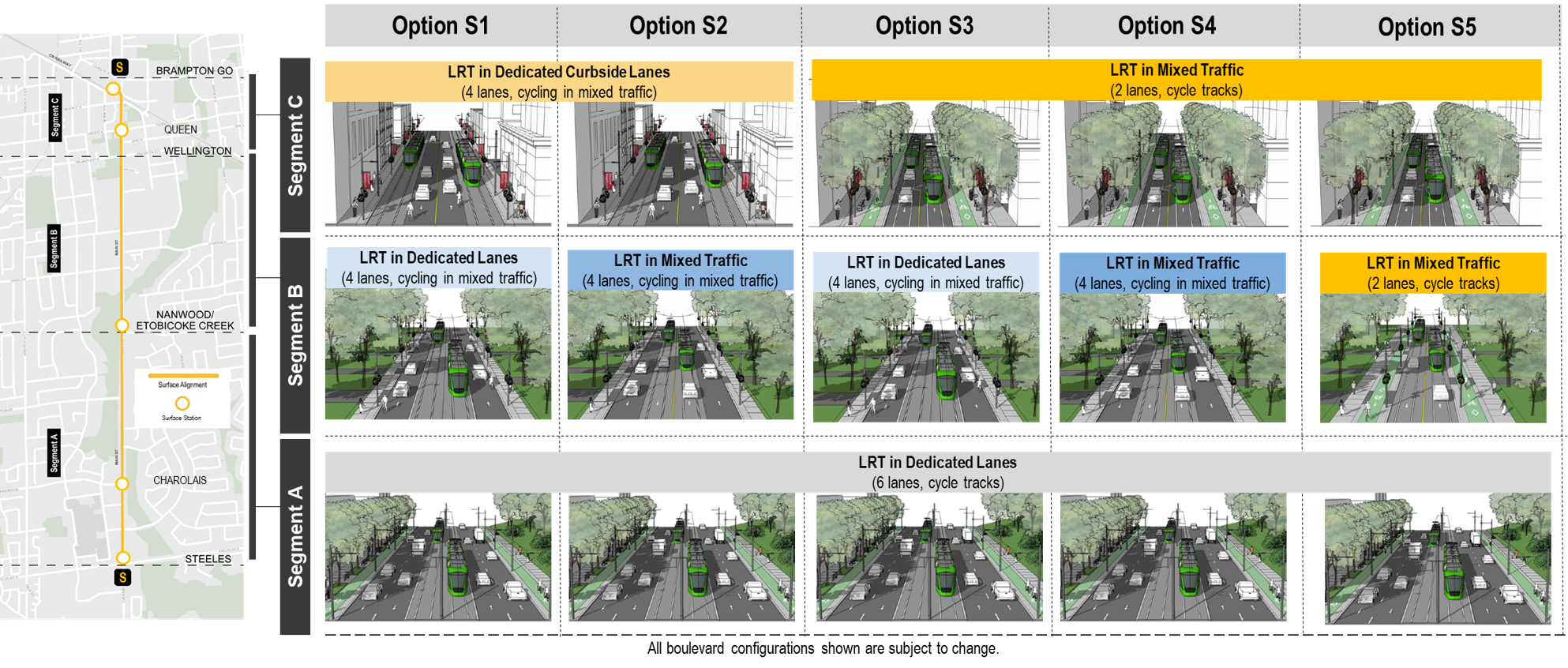
Short List Options
Since the last virtual open house in Summer 2020, we’ve evaluated the short list options (five surface and two underground). The loop options presented in the previous open house were not advanced to the short list for further assessment due to physical constraints (i.e. issues accommodating longer Light Rail Vehicles / impacts to property).
Short List: Surface Options
 Click on the image to enlarge.
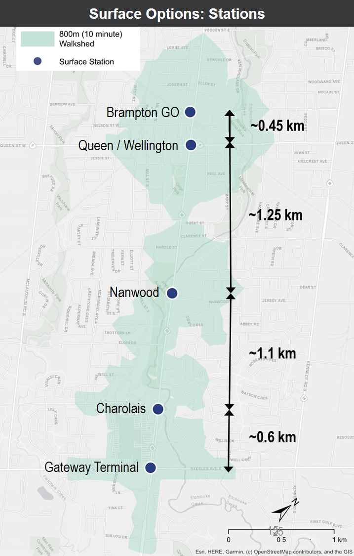
Proposed Station Locations
- Brampton GO
- Downtown (split platform)
- Queen (Northbound)
- Wellington (Southbound)
- Nanwood
- Charolais
- Gateway Terminal
Note: Station locations for surface options are consistent with 2014 TPAP recommendations.
 Click on the image to enlarge
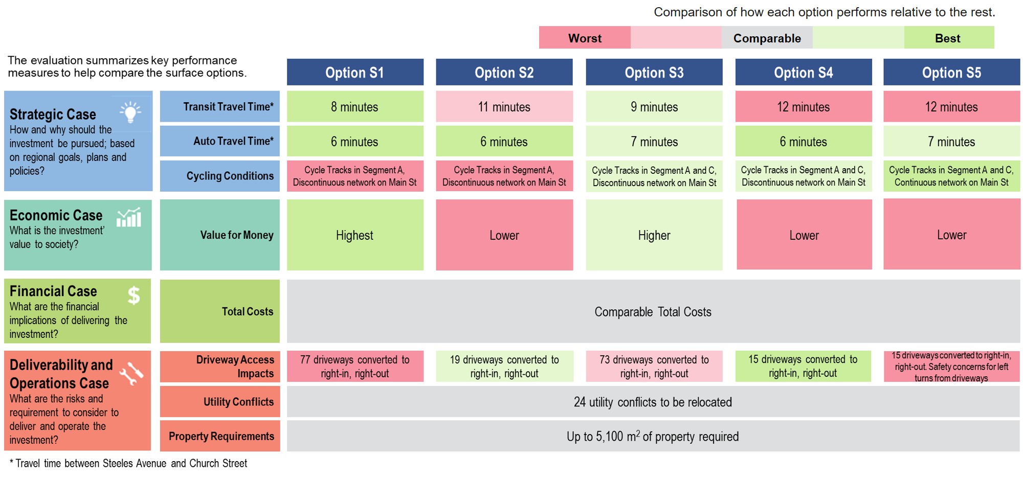
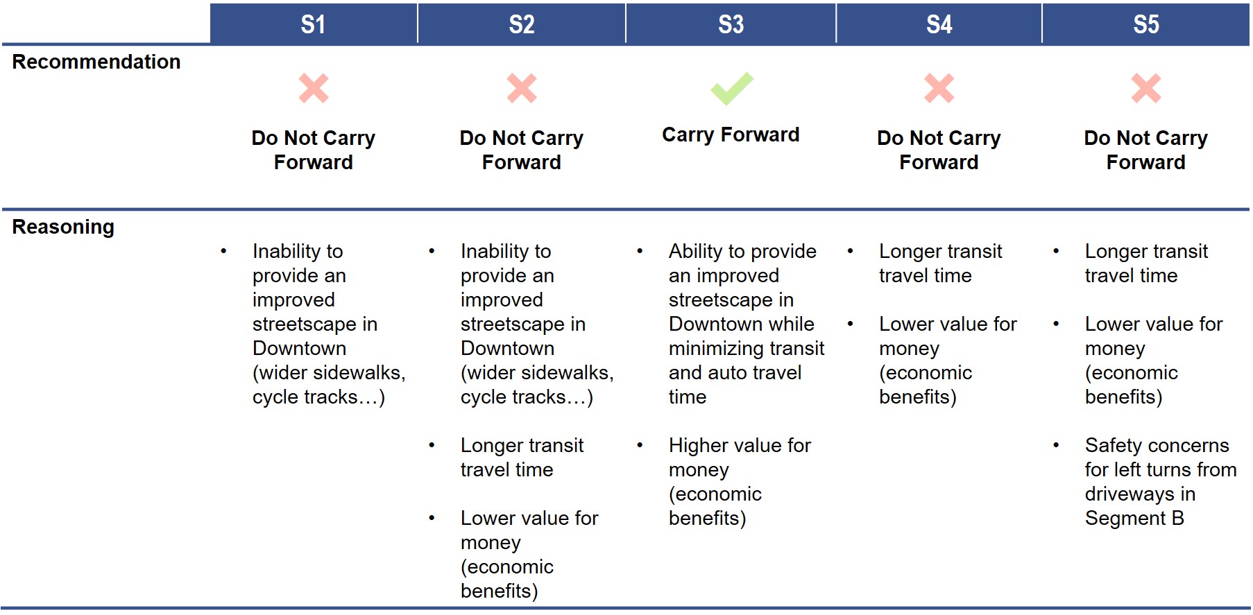
Surface Options: Evaluation Summary
 Click on the image to enlarge
 Click on the image to enlarge
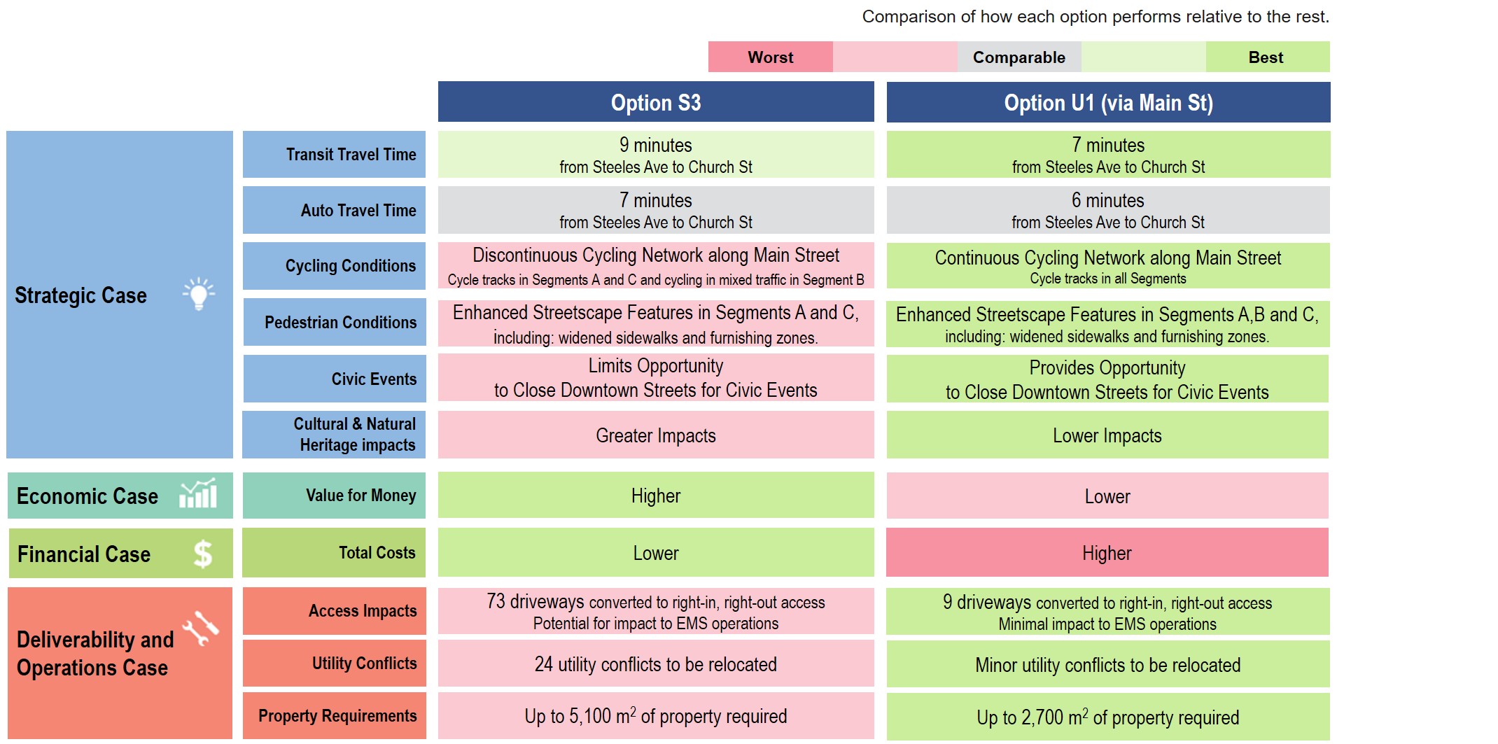
All surface options perform relatively similar; however, Option S3 provides the opportunity to revitalize Downtown Brampton into an aesthetically beautiful, place-making destination with wider sidewalks, streetscaping, and cycle tracks (consistent with Downtown Reimagined Vision) while minimizing overall transit travel time.
Driveway accesses will be modified as a result of the dedicated LRT right-of-way, but this will ensure safe and efficient travel for all users of the street.
Therefore, Option S3 is the emerging preferred surface option.
Short List: Underground Options 1 (Main St) & 2 (George St)
 Click on the image to enlarge.
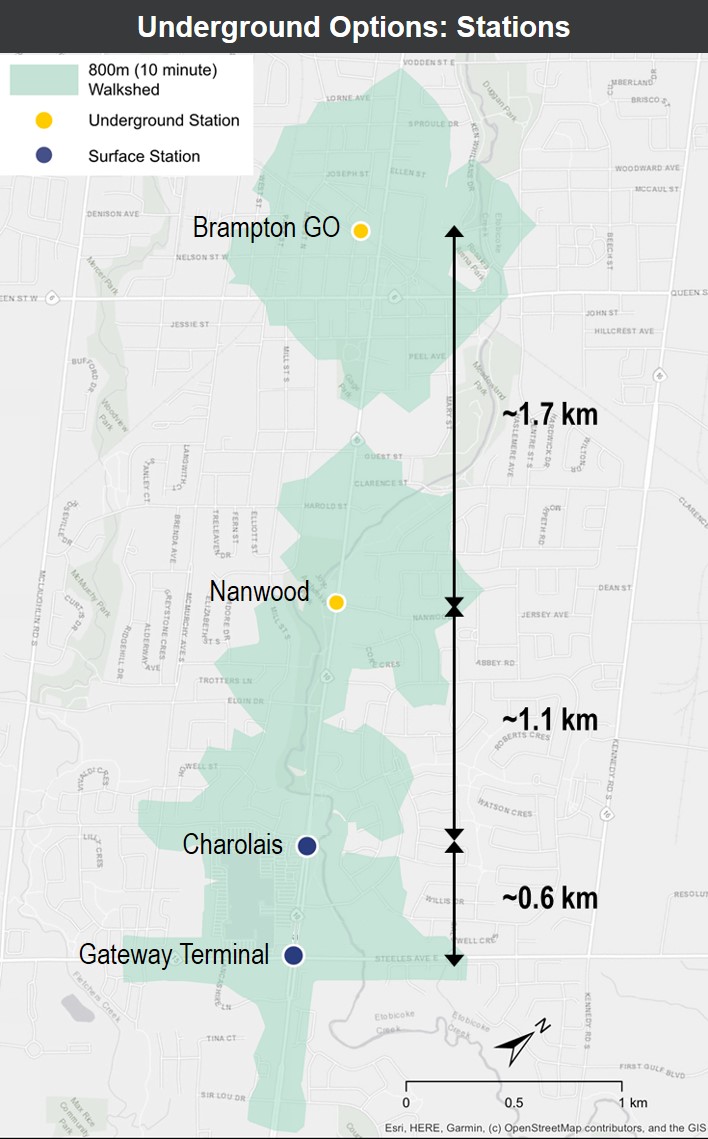
Proposed Station Locations
- Brampton GO
- Nanwood
- Charolais (surface stop)
- Gateway Terminal (surface stop)
Note: A station at Wellington Street was screened out during short list phase due its proximity to Brampton GO Station and high cost.
 Click on the image to enlarge
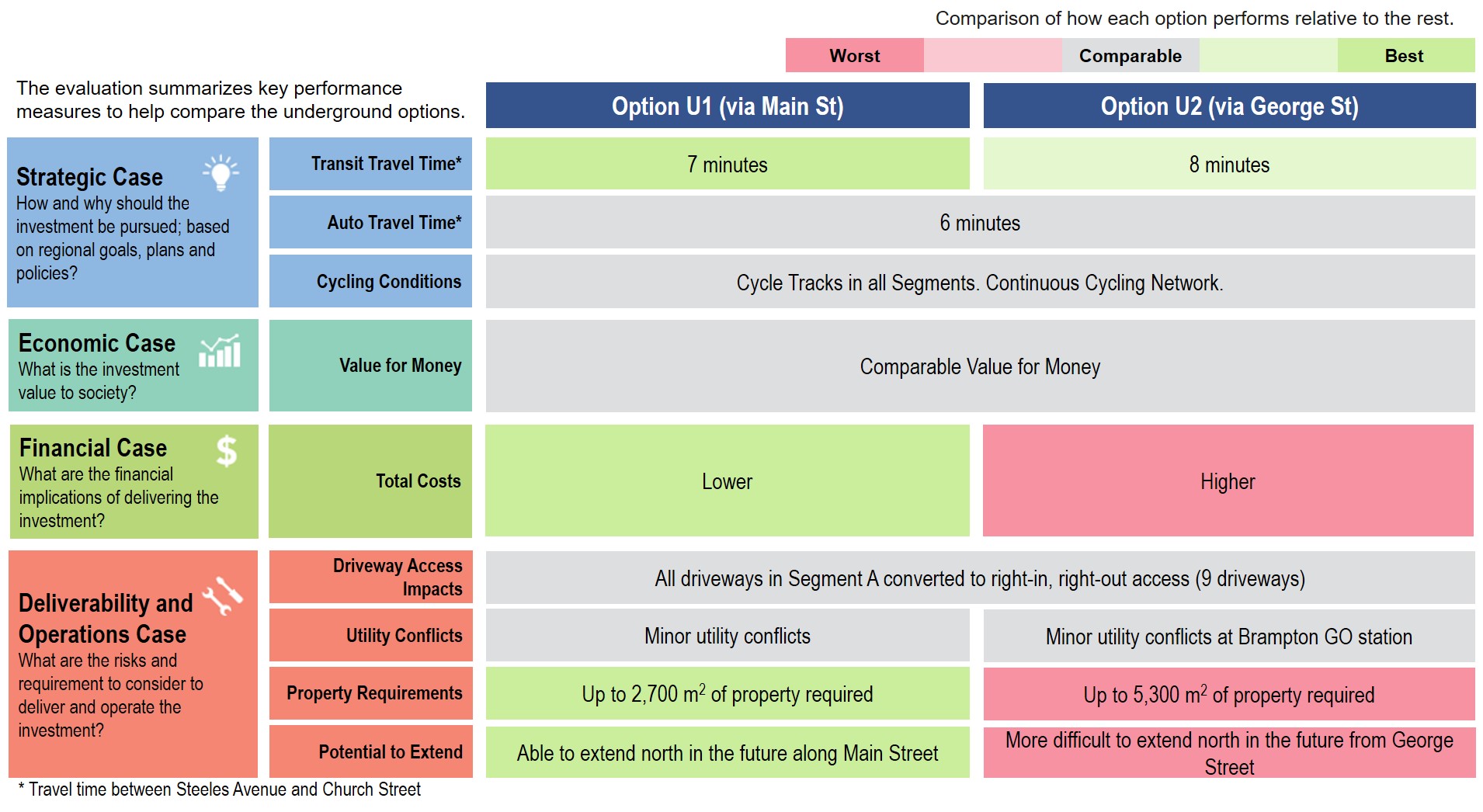
Underground Options: Evaluation Summary
 Click on the image to enlarge
 Click on the image to enlarge
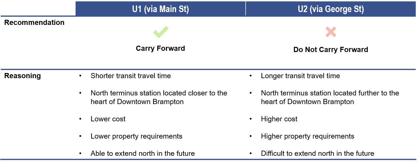
Option U1 (via Main Street) and U2 (via George Street) perform similarly from a strategic perspective. However, Option U1 is more preferred than U2 as it is less costly, located closer to the heart of Downtown Brampton, requires less property takings and is more easily extended north in the future.
Therefore, Option U1 is the emerging preferred underground option.
Emerging Preferred Options
Surface Option: S3
- The LRT will run in dedicated lanes between Steeles Avenue and Wellington Street and in shared lanes from Wellington Street to the Brampton GO Station.
- Option S3 allows for an enhanced streetscape in Segments A and C, including: cycle tracks, widened sidewalks, and a planting and furnishing zone. Cyclists must ride in mixed traffic in Segment B or use parallel routes.
- Driveways in Segment B will be modified to right-in, right out access.
- Overhead catenary systems and traction power substations (TPSS) will be located above ground in the study area.
 Click on the image to enlarge
Underground Option: U1 (Main St)
- The LRT will run in dedicated lanes north of Steeles Avenue to Elgin Drive then run underground from just south of Nanwood Drive to the Brampton GO Station along Main Street.
- Option U1 allows for an enhanced streetscape in Segments A, B, and C, including: cycle tracks, widened sidewalks, and a planting and furnishing zone. Option U1 allows for a continuous cycling network along Main Street.
- No access modifications are required in Segment B. Traction Power Substations (TPSS) will be located underground within underground station.
- The portal and the two underground stations are located in the floodplain. Potential impacts to be mitigated.
 Click on the image to enlarge
PDBC Summary
 Click on the image to enlarge
When comparing the two emerging preferred options:
Note: Cost estimates for the long list options were presented to Committee of Council on May 15, 2019. Refined cost estimates will be developed and presented during the next phase of the study.
- Both options provide comparable auto and transit travel times and have similar opportunities for economic development within the City and in the Downtown.
- The surface option has a lower cost, provides better value for money and can be constructed more quickly. However, it has more impacts to driveway access, utility, and property.
- The surface option does not allow for a continuous cycling network along Main Street (gap in Segment B) and limits the City’s ability to have civic events (such as Farmer’s Markets) on Main St in the Downtown without impacting LRT operations.
- The underground option provides many of the benefits that the surface option lacks while minimizing impacts at the surface; however, this comes at a higher cost, worse value for money, and will take longer to construct.
Next Steps
The Preliminary Design Business Case is currently being reviewed by Metrolinx and will be released to the public following their review.
Following virtual Open House 2, the project team will review and summarize feedback provided by the public and stakeholders.
Staff will prepare a Council Report to update Council on the Public Feedback Report and recommendation for next steps.

 Visit our website to get information about the study or sign-up to our mailing list and study notifications.
 Email the Project Manager
 905-874-2581