Front Range Passenger Rail Online Meeting
Welcome
Thank you for your participation in our online meeting for the Front Range Passenger Rail (FRPR) Project! We would like to share an update and receive your input on the project’s development. Your feedback is important for moving this project forward.
This meeting will remain available through the end of July.

How to navigate this meeting
Reviewing and providing your input should take no more than 15 minutes to complete. We look forward to receiving your input and continuing to work with you throughout the project.
- Click on the arrows on the right side of your screen.
- Use the navigation bar at the left of your screen to revisit any part of the meeting.
- Please provide feedback where indicated.
FRPR is part of Colorado's future!
As COVID-19 continues to create uncertainty and concern in Colorado and the U.S., we need to work together to ensure continuity of project work in a way that protects our collective health and well-being. For that reason, we are utilizing digital engagement tools to continue providing you with project updates and receiving your valuable input.
A Growing Need for a Transportation Solution
Plans for a comprehensive passenger rail system serving the Front Range have been under consideration for more than a decade, and as our transportation system has experienced a steady increase in population, the need for FRPR has only grown.
It is estimated that by the year 2050, an additional 3 million people will be living and commuting along the Front Range.
Projected Number of Employees along the Front Range in 2045
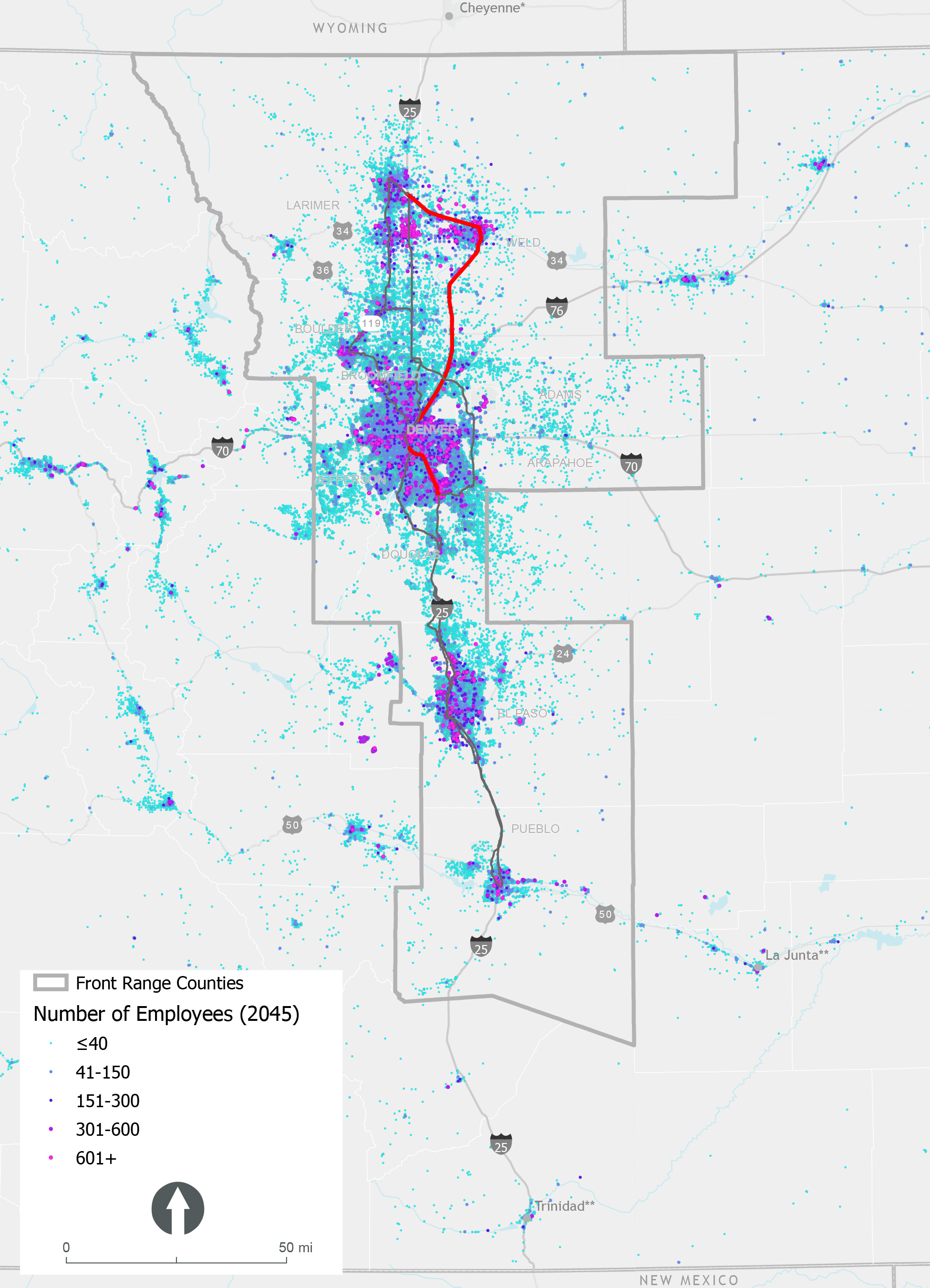 Click on the image to enlarge.
Projected Number of Households along the Front Range in 2045
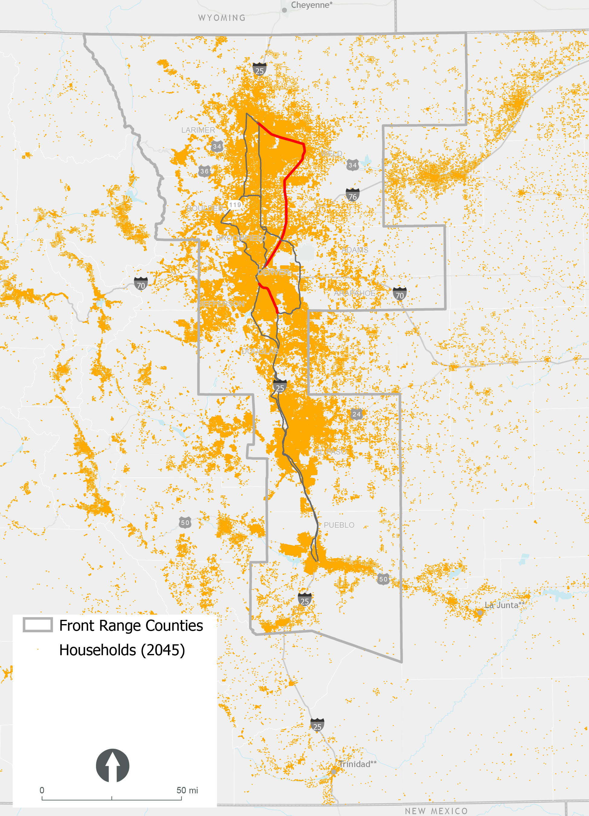 Click on the image to enlarge.
Our Vision Statement
Developing passenger rail that serves Front Range communities from Fort Collins to Pueblo is a critical component of Colorado’s future. FRPR will provide a safe, efficient, and reliable transportation option for travel between major population centers and destinations along the Front Range and create a backbone for connecting and expanding rail and transit options in the state and region.
 Click on the image to enlarge.
FRPR as an Important Solution
Click on each photo below to learn more about how FRPR would help address transportation needs in our region!
+RELIEVE CONGESTION PRESSURES
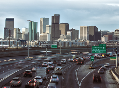
Population growth intensifies congestion on major highways, and expanding roadway capacity alone cannot meet transportation demands and travel needs; we can’t build our way out of congestion. The lack of reliable and time-competitive alternatives to single-occupancy vehicle intercity travel creates imbalance in the Front Range transportation network and stresses the region’s economic competitiveness and quality of life.
+PROVIDE NEW OPTIONS
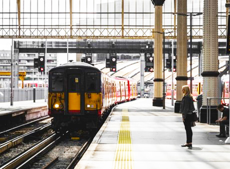
New multimodal travel options are needed to increase system capacity, serve regional travel demand, and balance the state’s transportation network Limited mobility choices currently exist to efficiently connect people along the Front Range to jobs, shopping, recreation, health care, leisure, entertainment, and other corridor destinations.
+REINFORCE STATEWIDE PLANNING AND PARTNERSHIPS
Passenger rail was identified in the State Freight and Passenger Rail Plan (2018) as a “critical component of Colorado’s future multimodal transportation system” and FRPR as the “primary opportunity to advance passenger rail” in the state. The Plan also recognizes the opportunity and need to work with freight railroads, rail operators (RTD, Amtrak), local governments, and private partners to leverage resources, coordinate land use and infrastructure investments, and realize opportunities of new technologies.
+ADDRESS GROWTH

Increasing population growth places more pressure on the state’s congested roadway network to provide reliable and efficient travel options. In the next 25 years (by 2045), there will be 7.8 million Coloradans, a population increase of 47%. Colorado’s population is highly concentrated, with 85 percent of the state’s population living along the Front Range (CDOT, 2019).
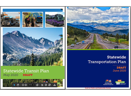
Creating a Tangible Plan
The Front Range Passenger Rail project is being developed by the Rail Commission, Colorado Department of Transportation (CDOT), and a consultant team.
We are currently working to create a tangible plan to bring the Front Range Passenger Rail to life and answer such questions as:
 Where would it go?
 What type of infrastructure and amenities would it include?
 Who would use it and why (what trips will it serve)?
 What would the operating schedule look like?
 How would it integrate with other modes – transit, roads, bike and pedestrian facilities?
 Who would build and operate it?
 How much would it cost and how could we pay for it?
Want to learn more about the history leading up to this stage of the Front Range Passenger Rail project?
Visit our project website for more information on previous studies, project development, and more.
Current Status
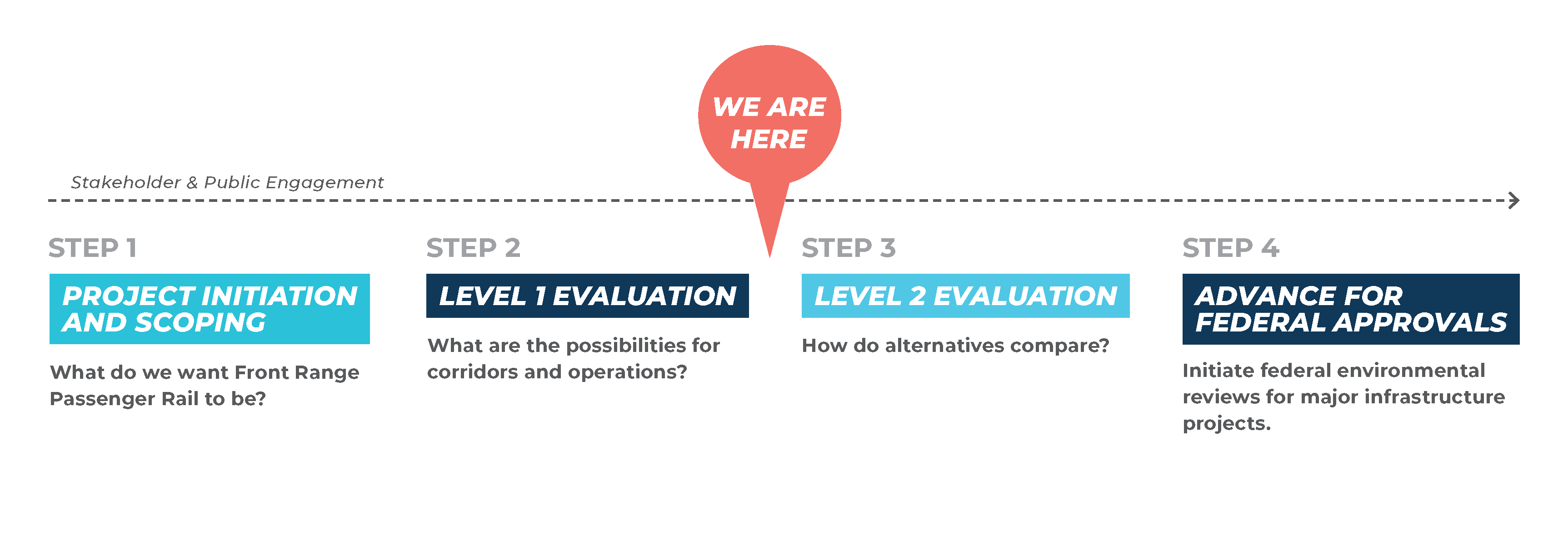 Click on the timeline to enlarge.
Alternatives Considered
Hover or tap the dots below to learn more about each Alternative.
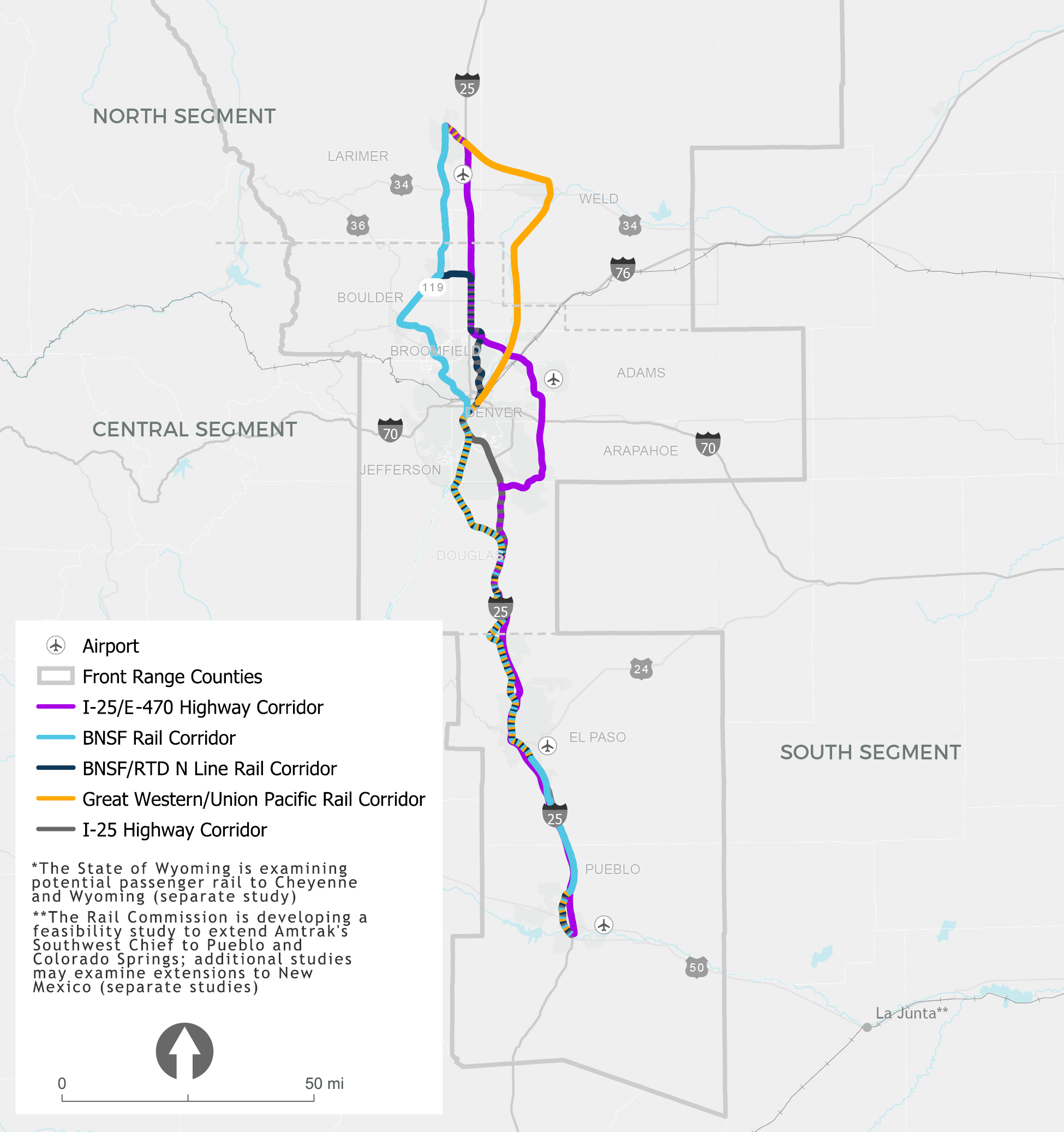
CARRIED FORWARD:
BNSF Rail Corridor
- From Pueblo to downtown Denver the corridor follows the joint BNSF/Union Pacific lines’ rights-of-way.
- From downtown Denver, the route follows RTD’s B Line to Westminster. From Westminster, the corridor turns west/northwest, traveling through Louisville, Broomfield, and Boulder.
- From Boulder, the corridor continues parallel to SH119 northeast to Longmont.
- From Longmont north to Fort Collins, the BNSF corridor is located west of I-25 and parallel to US287.
CARRIED FORWARD:
BNSF/RTD N Line Rail Corridor
- From Pueblo to downtown Denver the corridor follows the joint BNSF/Union Pacific lines’ rights-of-way.
- At downtown Denver, the corridor follows the planned RTD N Line commuter rail corridor to the future Thornton/SH 7 station.
- The alignment turns north and parallels I-25 until SH 119 and then along SH 119 into Longmont.
- From Longmont, the corridor travels north to Fort Collins along the BNSF right-of-way parallel to US 287.
CARRIED FORWARD:
I-25/E-470 Highway Corridor
- This corridor begins in Pueblo traveling along I-25 north to the Lincoln Station.
- The corridor then continues along E-470 around central Denver to the Denver International Airport and north to I-25.
- The corridor follows I-25 until it reaches Fort Collins corridor.
ELIMINATED:
I-25 (SE Corridor) RTD Light Rail Retrofit
- No available right-of-way.
- Severe community disruption.
- Interrupt RTD service for 6 years.
- Requires reconstruction.
ELIMINATED:
Great Western/Union Pacific Rail Corridor
- Does not serve 2045 population or employment centers.
- Does not provide backbone for connections with other modes.
- Limited public support or benefit as a backbone alignment.
OVERLAP:
- Dashed lines reflect an overlap of potential corridors.
Input Survey
Please answer a series of questions while reviewing the Alternative Corridors on the map.
Stakeholder Coalitions
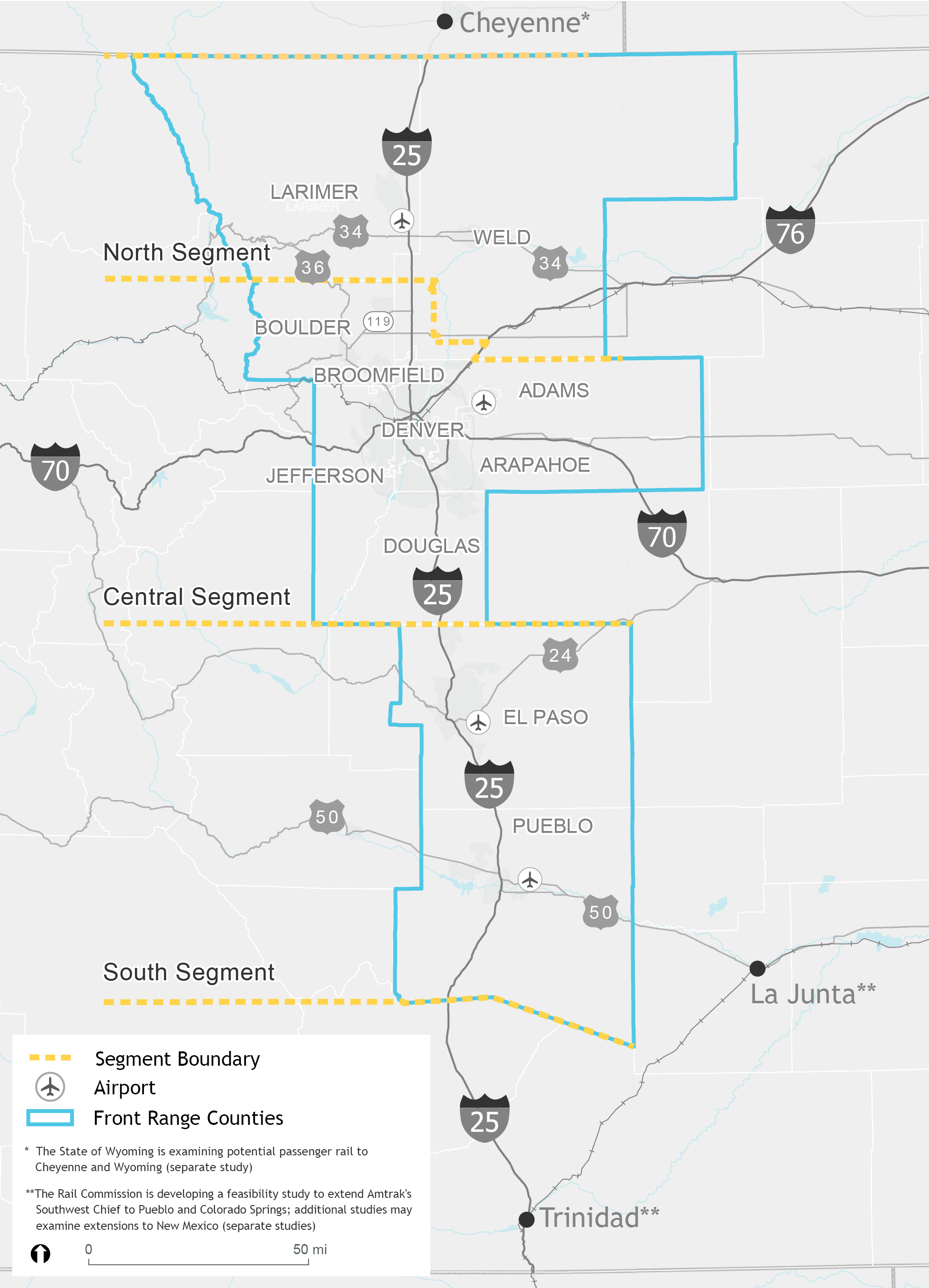
In order to appropriately plan for effectively serving such a vast geographic project area, the project team has broken the Front Range into three distinct segments. Local and regional agencies are involved in Corridor and Segment Stakeholder Coalitions.
Segment Coalitions
The three segment stakeholder coalitions (North, Central, South) represent diverse stakeholders from local communities in their segments:
 Government Agencies (GOVT)
 Educational Institutions (EDU)
 Major Employers (EMPL)
 Airports (AIRP)
The primary responsibilities of segment coalition members are to provide input on localized project-related issues and serve as liaisons between the FRPR project and members of their community.
Corridor Coalition
The corridor stakeholder coalition is made up of representatives from each segment coalition and combines the community-focused input into cohesive corridor-wide input. The input gained is used to inform the Front Range Passenger Rail project direction and decisions.
North Segment
 Click on the image to enlarge.
Additional Considerations based on Stakeholder Coalition Input
- Considerations for smaller towns/communities
- The need to consider the first and final mile solutions (particularly relevant for smaller communities that have less access to major transit systems)
- The ability for smaller towns to work with regional hubs
- Potential for significant economic development
- I-25 congestion relief
North Segment Coalition


Central Segment
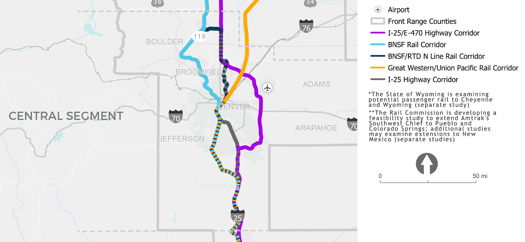 Click on the image to enlarge.
Additional Considerations based on Stakeholder Coalition Input
- Environmental impact (air quality, carbon emissions, etc.)
- Economic diversification
- I-25 congestion relief
- Station locations
- Interface with other transportation options
Central Segment Coalition


South Segment
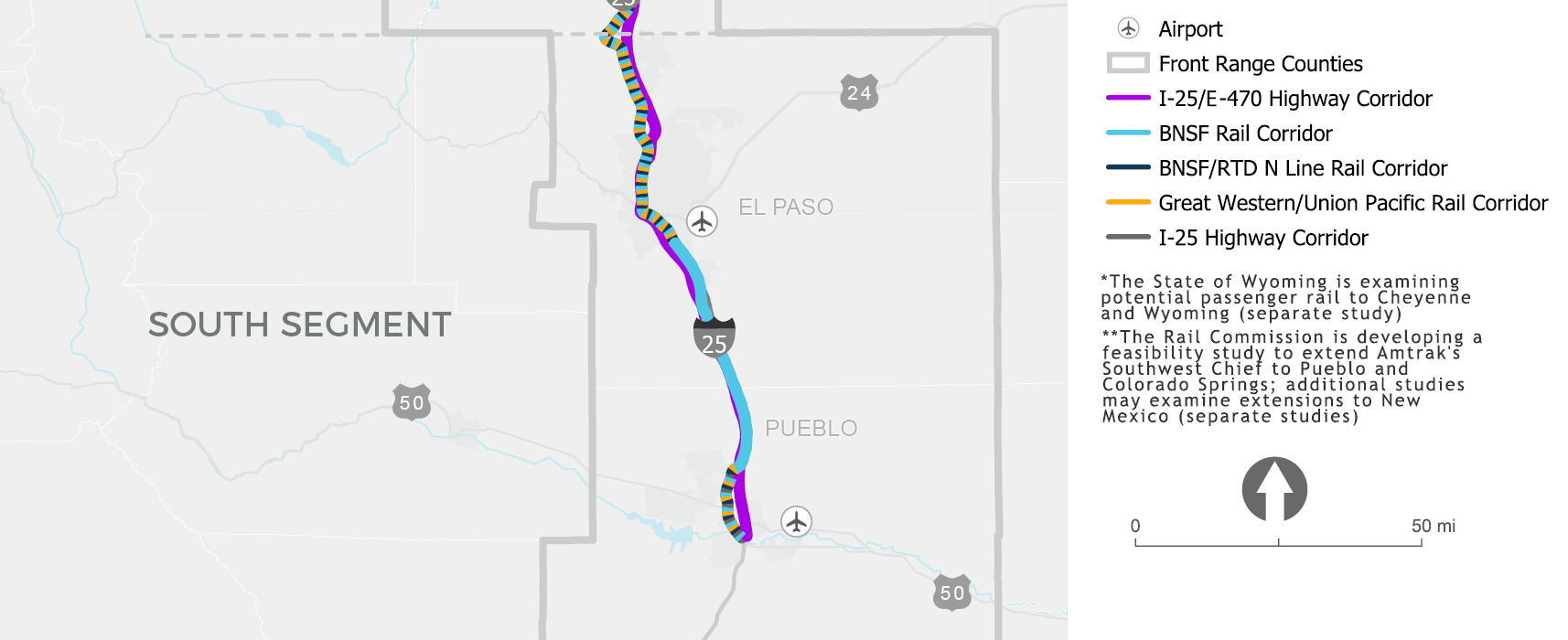 Click on the image to enlarge.
Additional Considerations based on Stakeholder Coalition Input
- Economic opportunities (e.g., jobs and cost-savings: both for individuals and communities)
- Recreation opportunities
- Importance of engaging all military installations in the development of FRPR
- I-25 congestion relief


