LAKEWOOD ROAD
ALGONQUIN ROAD TO ACKMAN ROAD
Welcome
McHenry County Division of Transportation (MCDOT) – Virtual Public Information
Meeting
Thank you for your participation in our online Virtual Public Information Meeting!

Language Translation
To translate the content of the meeting, use the following options.
Para traducir el contenido de la reunión, use las siguientes opciones.
How to Navigate
- Click on the arrows on the right and left sides of your screen.
- Click on an image to see an enlarged visual, where noted.
- Use the navigation bar at the left of your screen to revisit any part of the meeting. Mobile device users can access the navigation bar by clicking the icon in the upper left corner of the screen.
- Use the scroll bar on the right side of the screen to move the view up or down to see the entire slide.
How to Participate (Step 1)
- Click through the slides to learn about the project.
- Provide a comment at any point by clicking the “Comment” button at the top right of your screen. You may close the form to continue through the slides. Once finished, please make sure to hit “Submit” to confirm that your comment is sent to the project team.
- Once the comment form is filled out and submitted, your comments for this session will be complete. If you would like to provide multiple comments, please include all of them in a single comment upload.
- Comments can be submitted in person, if desired, at the Lake in the
Hills Village Hall.
Lake in the Hills Village Hall
600 Harvest Gate
Lake in the Hills, IL 60156- Hard copies of this presentation and comment forms can be found at the Lake in the Hills Village Hall or downloaded from the following link:
https://www.mchenrycountyil.gov/county-government/departments-j-z/transportation/future-construction/lakewoodroad- Comments submitted on or before December 1, 2020 will be addressed during the Live Virtual Presentation and Q&A Session. Comments submitted during the November 19, 2020 to December 17, 2020 comment period will be addressed in the Virtual Public Information Meeting Report.
- Hard copies of this presentation and comment forms can be found at the Lake in the Hills Village Hall or downloaded from the following link:
Join Us for the Live Virtual Presentation and Q&A Session (Step 2)
Your questions and comments will be answered and shared during the Live Virtual Presentation and Q&A Session from 5:00PM to 7:00PM on December 3, 2020.
Please check the project website or McHenry County Division of Transportation's Facebook page for the link to the Live Virtual Presentation and Q&A Session.
A Virtual Public Information Meeting Report will be posted to the project website after the comment period providing information on the feedback received.
Link to the Live Virtual Presentation and Q&A Session to be added when available
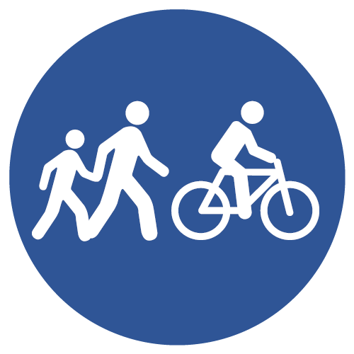
Project Overview
Lakewood Road Improvements
MCDOT is studying corridor improvements for Lakewood Road between Algonquin Road and Ackman Road, in the Village of Lake in the Hills. The project will:
| Complete Traffic Operation Improvements at Miller Road | Provide Pedestrian and Bike Facilities | Improve Safety |
|---|---|---|

|
|

|
Project Location
Click image to expand.
Need for Project
Primary Needs to Address
At the May 30, 2019 Public Open House, McHenry County residents and Lakewood Road users provided information to the project team about their observations regarding Lakewood Road. This shared understanding helped define the needs of the project.
Traffic
Temporary signals currently are in place at the Lakewood Road and Miller Road intersection. To improve safety and reduce delay, a permanent intersection solution will be provided.
- Large.JPG)
Lakewood Road and Miller Road Intersection
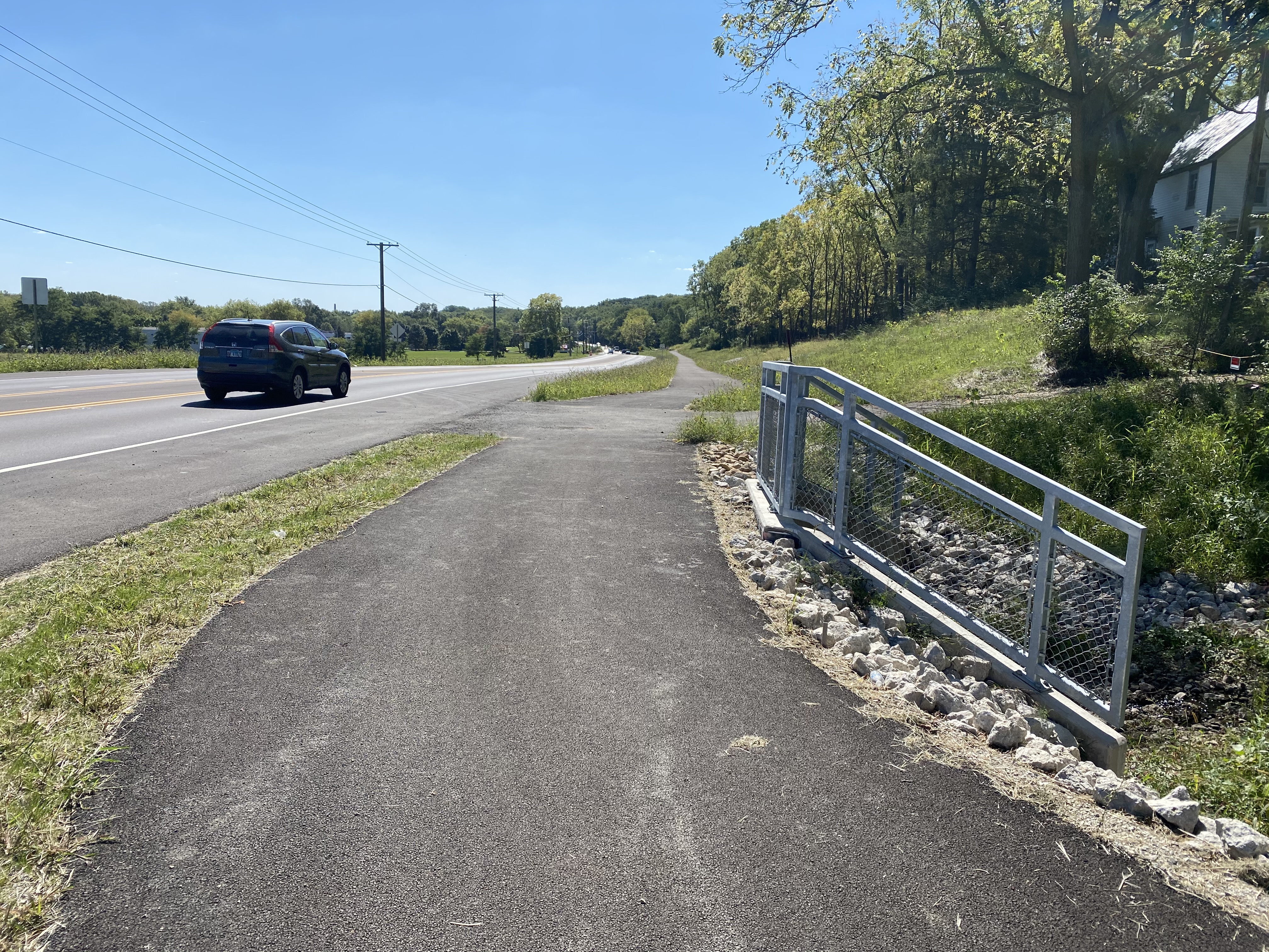
Pedestrian and Bicyclist
Bicycle and pedestrian paths currently do not exist along the Lakewood Road corridor. Pedestrians and bicyclists can often be seen riding and jogging along Lakewood Road. This project will address this need by providing pedestrian and bicycle accommodations along Lakewood Road.
 - Large.jpg)
Bicyclists Along Lakewood Road
Drainage
Ponding of storm water can be found in ditches and curbs along Lakewood Road. Ditches will be reestablished and storm sewers will be considered at locations with ponding issues.
 - Large_iOS.png)
Off-Road Ponding Example
 - Large_iOS.png)
On-Road Ponding Example
Identifying Solutions
Improvements to the Miller Road Intersection,
Bicyclist/Pedestrian Connectivity, and Drainage
We have collected data, analyzed it, and received input about your experiences on Lakewood Road. The next step in the process is to develop a range of solutions to address issues in the corridor. We use the needs discussed in the previous slide to help determine if the solutions address the needs.
Solutions
- Does the solution decrease traffic delay now and in the future?
- Does the solution improve connectivity and provide a safe active transportation option?
- Does the solution allow for storm water improvements along the corridor?
- If the answer to these questions is “yes”, then we look at other considerations such as:
Process
Alternative Designs
(We are here)
Alternative Design

Safety
- Does the proposed solution improve public safety?

Natural and Built Environment
- Does the solution require additional right-of-way?
- What impacts to the environment does the solution have?
- Does the solution visually fit into the area?

Construction Costs
- What are the relative costs of each solution?
- What construction impacts does the solution have?

Sustainability
Note: Envision is a framework developed by the Institute for Sustainable Infrastructure that provides guidelines to help designers of infrastructure projects increase sustainability features
- What features of the project improve the sustainable performance and resiliency as provided in the Envision framework?
- What features of the project improve social, economic, and environmental sustainability?
Continue clicking through the slides to learn about three intersection options as well as two pedestrian and bicycle options and give us your input!
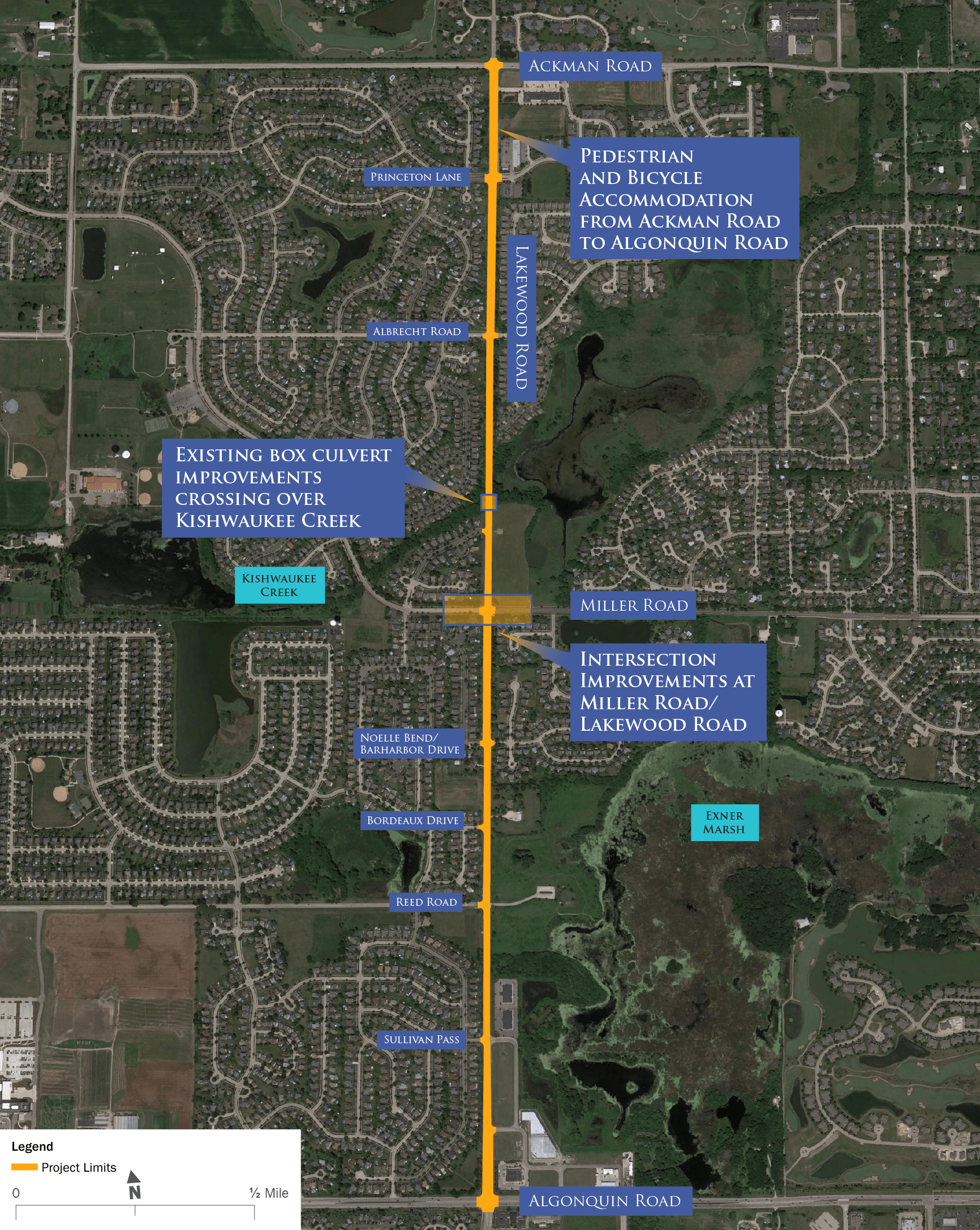
Intersection Option: Signalized
Upgraded Modern Traffic Signals with New Right Turn Lanes
Click image to expand.
- Improves travel time and reduces traffic delays by replacing temporary signals at intersection with permanent solution
- Shortest construction duration
- Lower construction cost
- Familiar intersection configuration
- Least aesthetic appeal
- Longer distances for pedestrians and bicyclists to cross the street
Intersection Option: 150' Roundabout
150’ Diameter Roundabout
Click image to expand.
- Improves travel times and reduces delays
- Reduces right-turn wait times
- No waiting during low traffic times (waiting at a red light)
- Improves vehicle safety by reducing speeds and preventing angle and head-on collisions
- Provides greater opportunity for aesthetic enhancements
- Improves pedestrian safety by reducing speeds
- Shorter crossing distances for pedestrians and bicyclists
- Provides more flexibility to manage special event traffic
- Requires more right-of-way
- Longer construction duration
- Higher construction cost
As compared to the signalized intersection alternative:
Intersection Option: 120' Roundabout
120’ Diameter Roundabout
Click image to expand.
- Improves travel times and reduces delays as compared to the 150' roundabout alternative
- Reduces right-turn wait times as compared to the 150' roundabout alternative
- No waiting during low traffic times (waiting at a red light)
- Improves vehicle safety by reducing speeds and preventing angle and head-on collisions
- Provides greater opportunity for aesthetic enhancements
- Improves pedestrian safety by reducing speeds
- Shorter crossing distances for pedestrians and bicyclists
- Provides more flexibility to manage special event traffic
As compared to the signalized intersection alternative:
- Requires more right-of-way
- Longer construction duration
- Higher construction cost
Ped. & Bicycle Option: Dual Multi-Use Path
Multi-Use Path Along Both Sides of Lakewood Road
Multi-Use Path Layout

Click image to expand.
Click image to expand.
Click image to expand.
Click image to expand.
- Provides best connectivity for pedestrians and bicyclists
- Separates pedestrians and bicyclists from roadway traffic
- Decreased number of Lakewood crossings for bicyclists
- Requires more right-of-way acquisition than multi-use path and sidewalk alternative
Ped. & Bicycle Option: Multi-Use Path & Sidewalk
Sidewalk (West Side) and Multi-Use Path (East Side) Along Lakewood Road
Multi-Use Path Layout

Click image to expand.
Click image to expand.
Click image to expand.
Click image to expand.
- Provides a high level of connectivity for pedestrians and cyclists
- Separates pedestrians and bicyclists from roadway traffic
- Less connectivity for bicycle users than the alternative with multi-use paths along both sides of Lakewood Road
- Bicyclists may be required to cross Lakewood Road more frequently to reach their destination
Kishwaukee Creek Pedestrian and Bicycle Crossing
Pedestrians and bicyclists currently use a narrow shoulder to cross the Kishwaukee Creek on Lakewood Road. Two options have been identified to construct a safer crossing.
Pedestrian/bicycle crossing over water body with a wide culvert
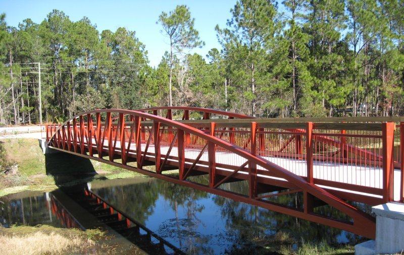
Pedestrian/bicycle crossing bridge over water body
Potential Improvements:
- Culvert extension to the current culvert
- Entire culvert replacement with longer culvert
- Smaller footprint
- Lower cost
Potential Improvements:
- Pedestrian bridge structures
- Greater aesthetics
- Increased safety with a greater separation from roadway traffic