Project Objectives
Purpose
The New Tecumseth Multi Modal Active Transportation Master Plan (TMP) will:
- Improve the movement of all users by identifying cost-effective, feasible and implementable alternatives
- Assess the existing and projected travel demand to the horizon year of 2041
- Improve safety and efficiency of the transportation network for all users
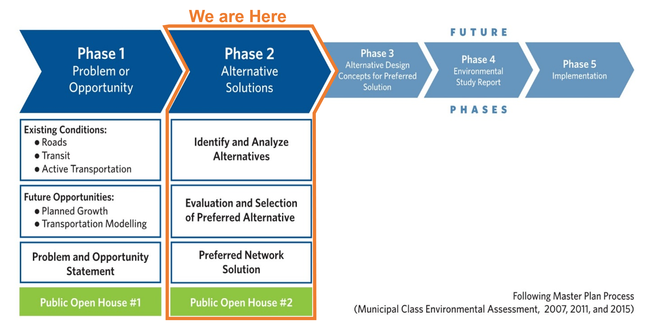
Following Phase 1 and 2 of the Environmental Assessment
Click the image below to enlarge.
Click the image below to enlarge.
Phase 1 Summary (1 of 2)
Population and Employment Growth
Based on preliminary 2041 estimates, New Tecumseth will experience significant growth between 2016 and 2041.
Click the image below to enlarge.
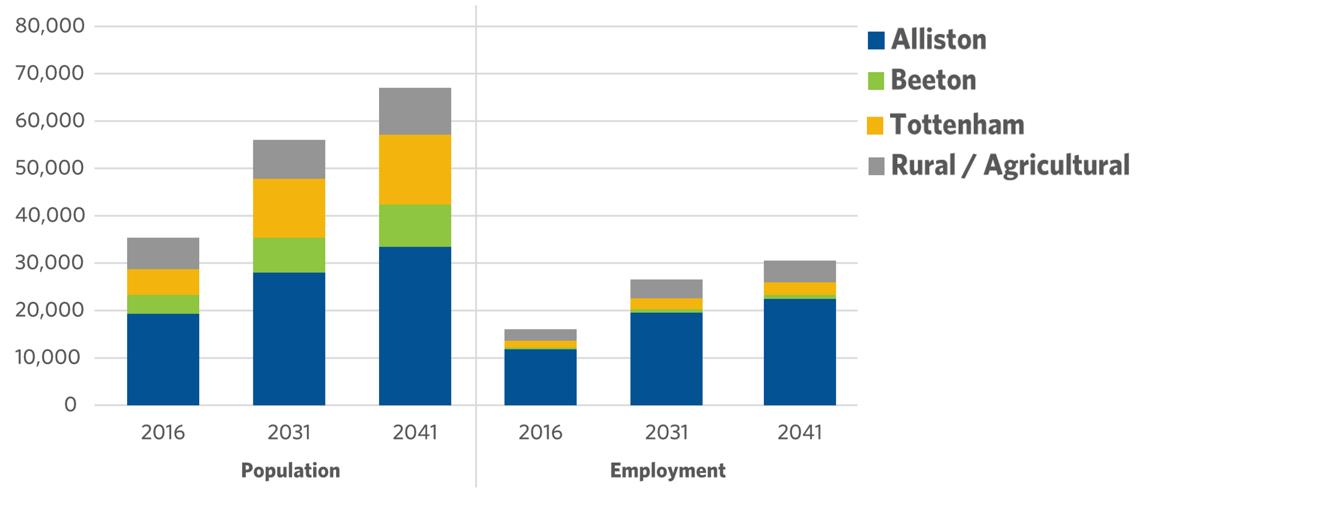

91%
Population growth between 2016 and 2041*

91%
Employment growth between 2016 and 2041
Note: The 2041 population and employment forecasts are estimates and subject to change. The County of Simcoe is currently in the process of a Municipal Comprehensive Review (MCR) to determine 2041 population and employment, which will then be subject to Provincial approval.
Drivers of Change
- New development in Alliston, Beeton and Tottenham will continue to increase traffic demand to, from and within the Town
- The opening of Line 5 interchange at Highway 400 is changing traffic patterns and road improvement needs
- Simcoe County LINX Transit Service is connecting Alliston to Bradford and the GO Station
- Desire for Local Town Transit Service
- Desire for better active transportation infrastructure
Future Development Areas and Growth in Traffic
By 2041, we anticipate significant growth in east-west travel to access County Road 27 and Highway 400 as well as north-south travel to Highway 9.
Click the image below to enlarge.
Key Traffic Issues
- North-south traffic volumes south of Tottenham.
- High vehicle and truck traffic volumes on Queen Street through Tottenham.
- East-west traffic volumes on Victoria Street in Alliston.
- Traffic operations issues at Victoria Street, King Street, Young Street and Albert Street in Alliston.
- East-west traffic volumes on Highway 89
- East-west traffic volumes through Beeton to access to County Road 27 and Highway 400.
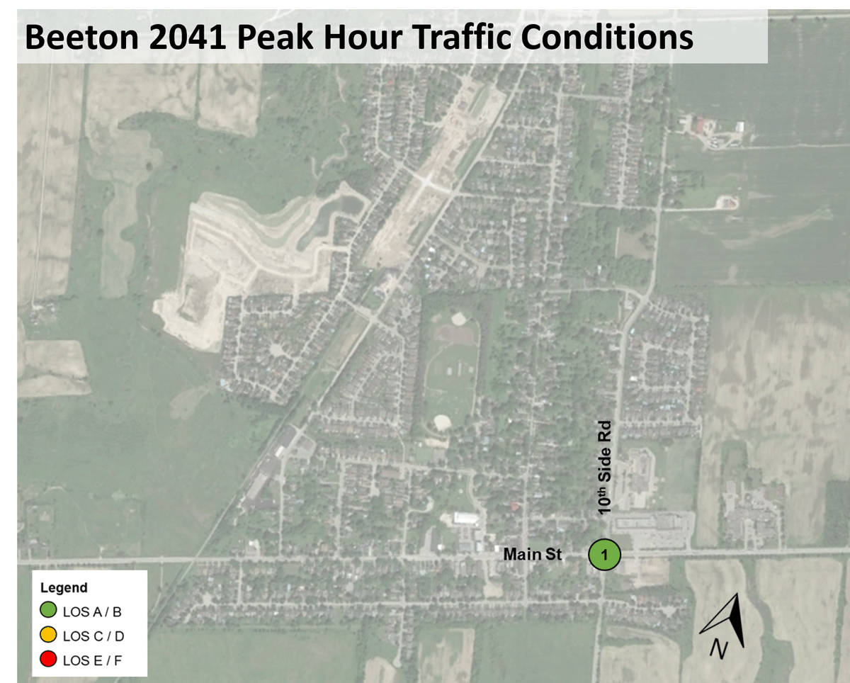
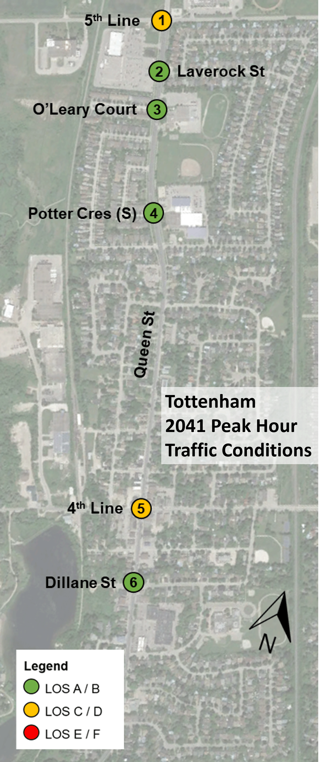
Phase 1 Summary (2 of 2)
Future Traffic Conditions – Traffic Signal Delay in Alliston, Beeton and Tottenham
Click the image below to enlarge.
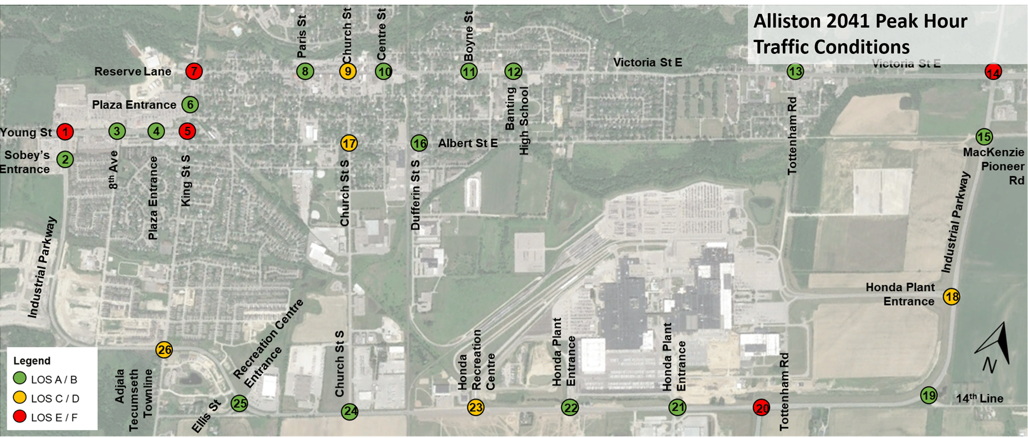
Growth will also put added strain on the transportation systems in the Town’s settlement areas – particularly in Alliston and Tottenham.
LOS A/B = Minor Delay
LOS C/D = Moderate Delay
LOS E/F = Significant Delay
Phase 1 Consultation
Community Pop-Up Events
Community pop-events were held across New Tecumseth and provided opportunities for the public to provide their input. Community pop-up events were held on:
- April 13, 2019: Tottenham Home Show and Artisan Market
- April 27, 2019: New Tecumseth Home & Leisure Show; and
- August 10, 2019: Alliston Potato Festival.
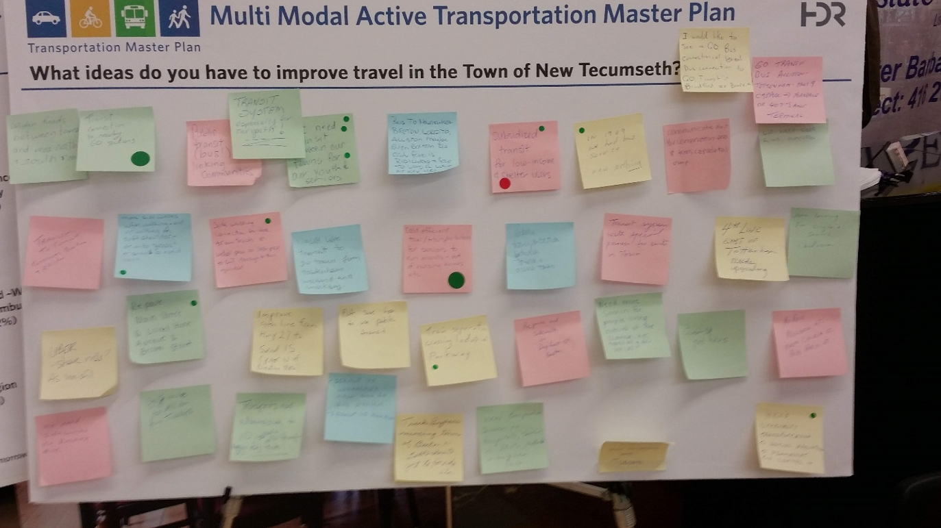
Key messages that we heard from residents included:
- Support for Transit: Residents generally responded positively to bringing some form of public transit to New Tecumseth, and recognized that is a need for youth and seniors.
- Improve Roadways: Residents generally responded positively to bringing some form of public transit to New Tecumseth, and recognized that is a need for youth and seniors.
- Improve Cycling/Active Infrastructure: Residents were supportive of improving cycling infrastructure within the Town, with many supporting the various cycling trails that already exist. Residents also commented that in many areas there are no sidewalks and would like to see more constructed.
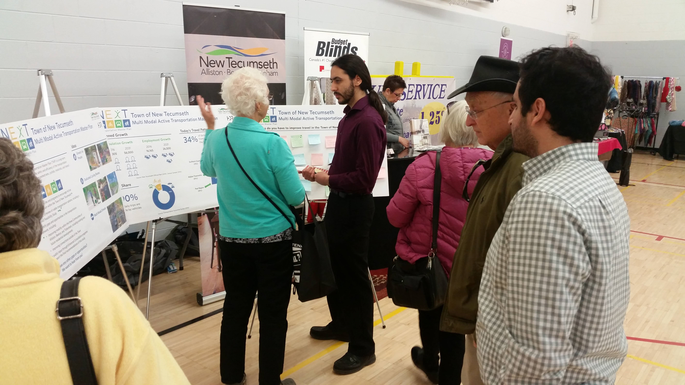
Open House #1: What We Heard
Open House #1 was held on October 3, 2019 at the administration centre at 10 Wellington Street East, Alliston. Key messages we heard from residents included:
- Lack of safe active transportation infrastructure generally throughout the Town. Suggestions included adding sidewalk to roads such as 11th Line, wider sidewalks, paved shoulders, adding or modifying crosswalks and better signage.
- Support for cycling infrastructure: Albert Street, Church Street, and King Street were identified as streets that are unsafe to bike on and require cycling infrastructure.

Other Engagement Activities
Other engagement activities carried out in Phase 1 included:
- Public Opinion Transportation Survey
- Student / Youth Transportation Survey
- Major employer Transportation Survey
- Meeting with major employers
- Meeting with local Business Associations
Problem and Opportunity Statement
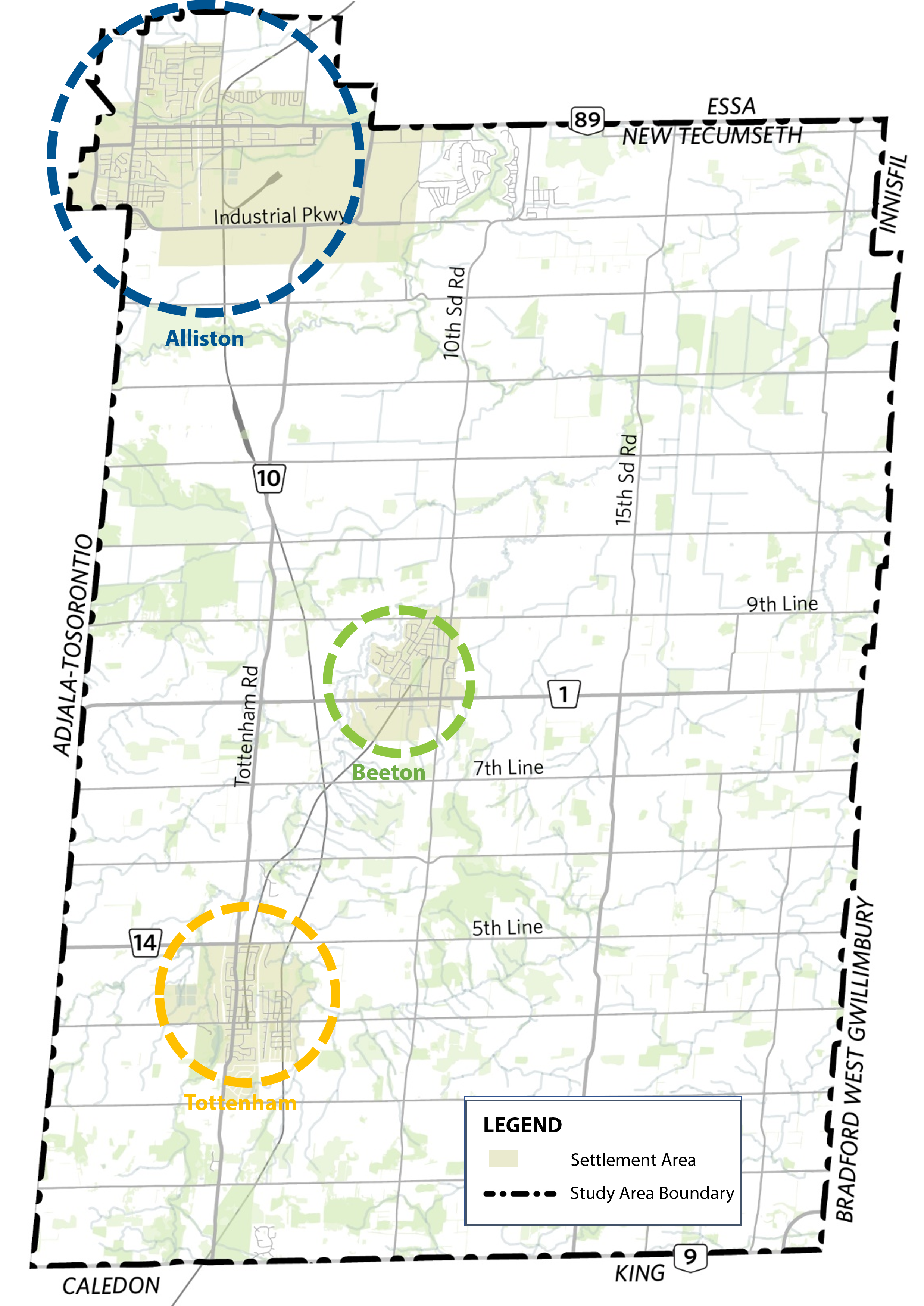
The Town of New Tecumseth is comprised of three distinct settlement areas and dispersed rural areas with limited connectivity between them. The automobile is the primary method of travel within the Town as there is no existing conventional transit service and limited active transportation facilities.
The Town of New Tecumseth’s population is expected to nearly double between 2016 and 2041, with the majority of this growth being targeted towards the existing settlement area of Alliston. This will cause strain and congestion on the existing road network if the current car-focused trends continue.
The Town can address these transportation issues through the following opportunities:

Provide transportation options that meet the needs of all Town residents, especially those without access to an automobile

Create complete streets which are accessible and safe for all users
Improve existing roads to ensure they can meet growing demand

Explore transit options and implementation opportunities
Encourage walking and cycling for short trips

Improve connections between the settlement areas and rural areas
Alternative Strategies
Overview
To address emerging issues, priorities, and initial feedback summarized in the Problem and Opportunity Statement, the project team identified four Alternative Strategies guide the development of the list of potential road improvements projects:
Alternative 1: Create a Town-wide Pedestrian and Cycling Network
Alternative 2: Transit Service Implementation Strategy

Alternative 3: Road Network Improvements
Alternative 4: Local Traffic Improvements
Alternative 1 - Create a Town-wide Pedestrian and Cycling Network
Alternative 1 - Create a Town-wide Pedestrian and Cycling Network
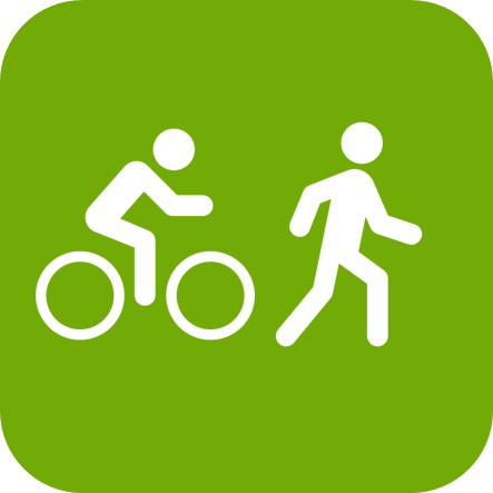
The project team developed a draft Active Transportation Network to address the needs and opportunities for cycling and walking in the Town of New Tecumseth.
The proposed network was developed to:
- Build connections to points of interest
- Link gaps in the existing cycling and pedestrian network
- Support and feed into the Active Transportation Plan
Highlights:
- Trans-Canada Trail connection between Beeton and Tottenham
- New Trail between Beeton and Alliston
- On-street cycling facilities within Alliston, Beeton and Tottenham
Proposed Active Transportation Network
Click the image below to enlarge.
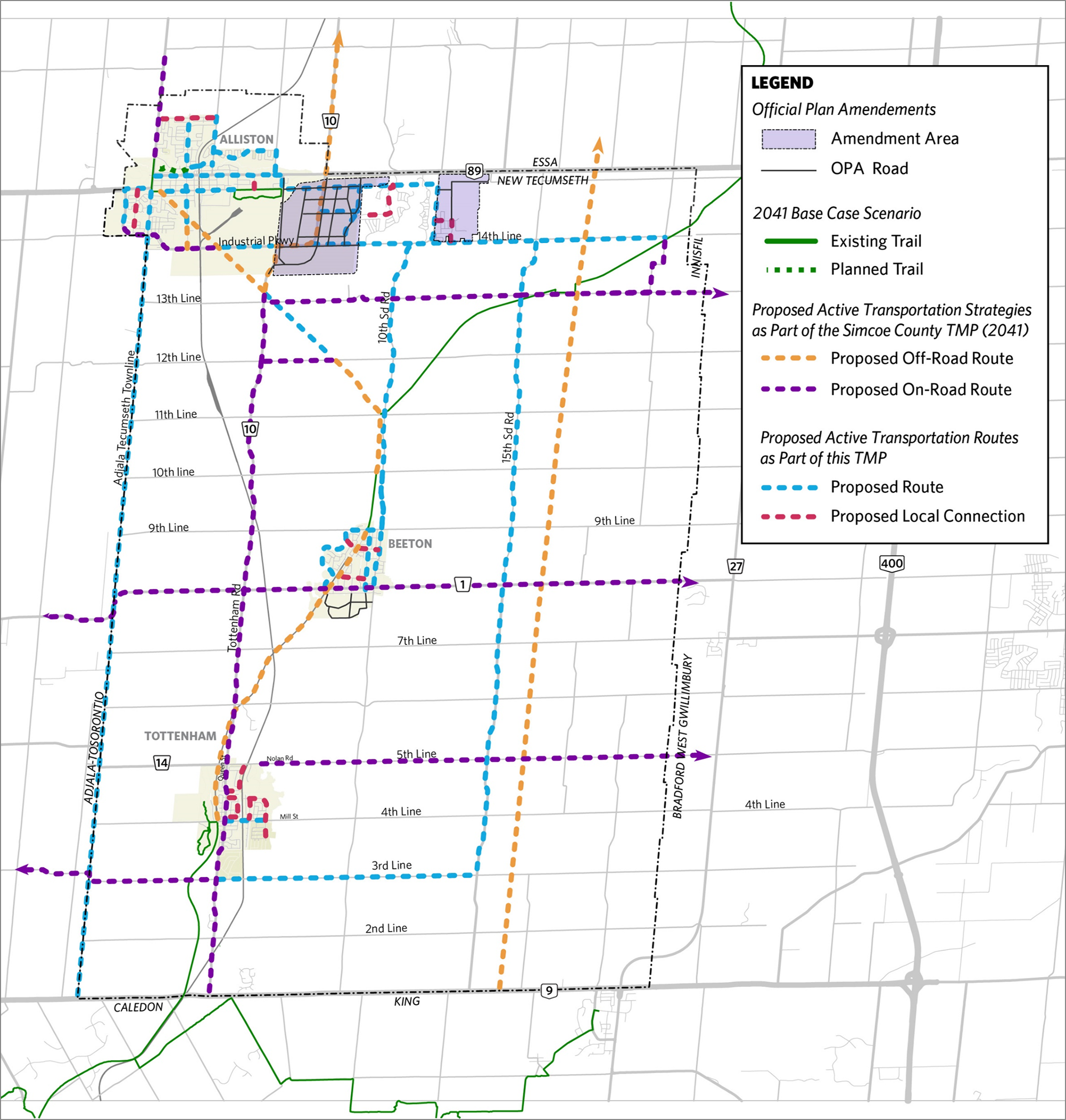
Routes shown are conceptual and subject to further study
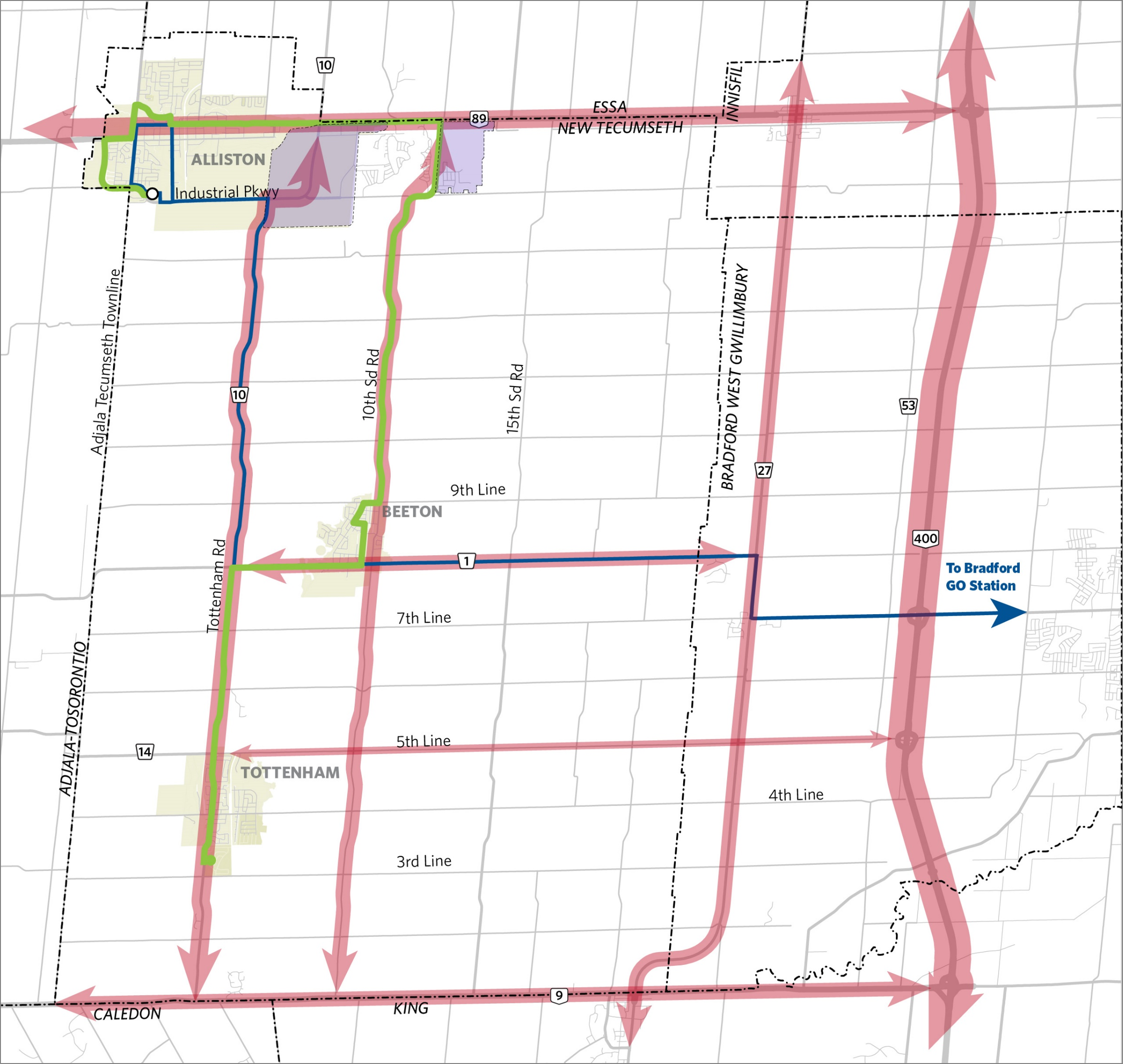
Alternative 2 - Transit Service Implementation Strategy
Alternative 2 - Transit Service Implementation Strategy
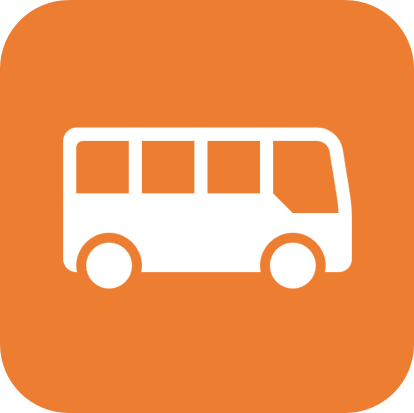
A Transit Feasibility Study was completed in 2019 and a preliminary fixed route service connecting Alliston, Beeton and Tottenham was endorsed by council in July 2019. This route will complement the County’s new LINX transit route connecting Alliston to Bradford GO Station via Beeton and Bond Head.
Next Steps
- Conduct a Transit Implementation Strategy Study to further refine routing and initial stop locations
- Investigate potential capital and operating funding programs from higher levels of government
- Review potential alternatives for accessible transportation
Proposed Route
Click the image below to enlarge.
Alternative 3 - Road Network Improvements
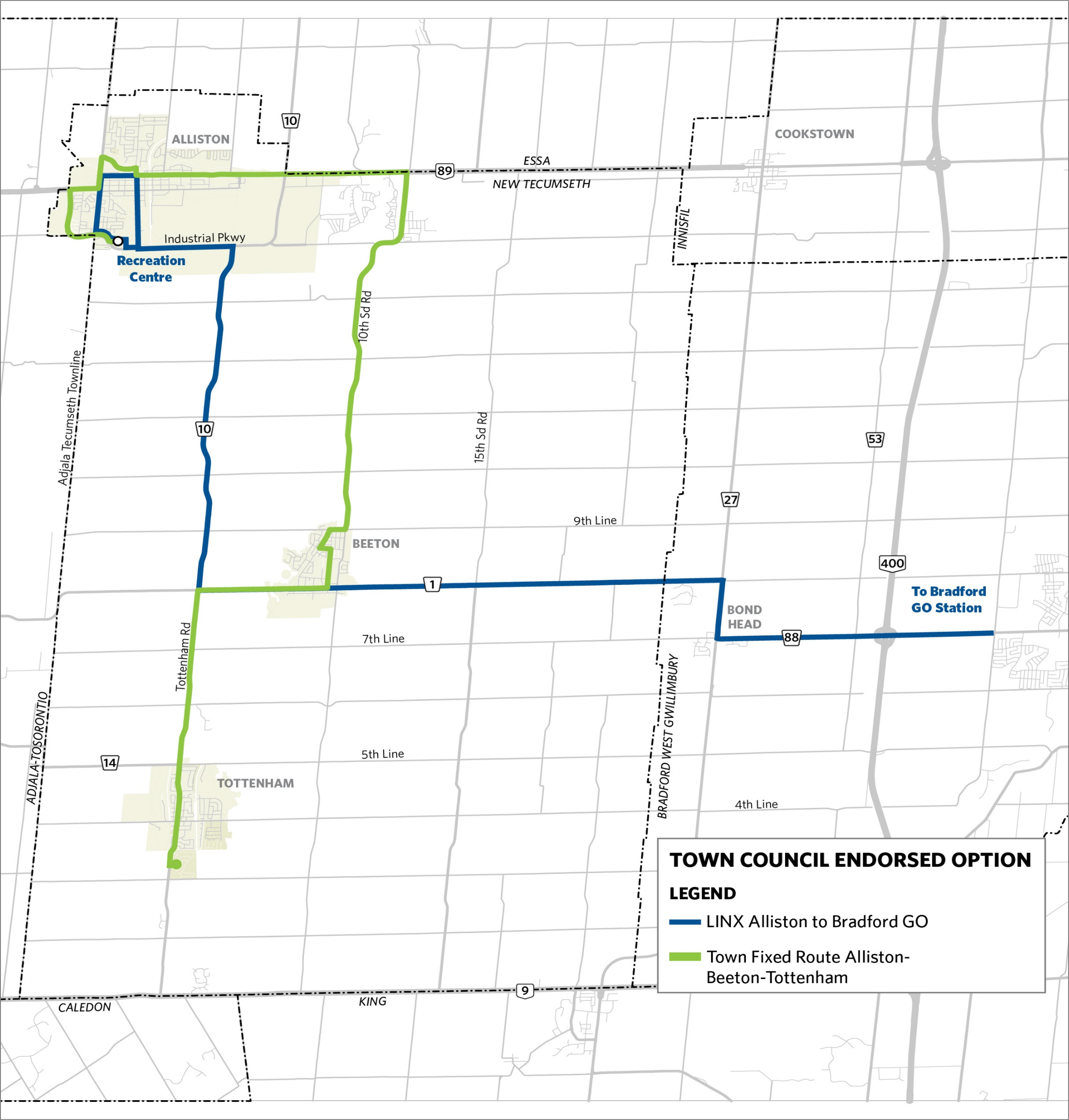
Alternative 3 - Road Network Improvements

Proposed Road Improvement Projects that have been identified to address key Town-wide traffic issues include:
- Road Widening
- New Roads
- Road Upgrades
Satisfying Municipal Class Environmental Assessment Requirements
Alternative solutions to address key traffic issues have been identified. These alternatives will be evaluated on a set of criteria which considers each project’s benefits and impacts.
2041 Base Case Scenario
These road improvement projects have been identified in consideration of other existing policies and plans, including Town Official Plan Amendments (OPA) and the Simcoe Transportation Master Plan (2014).
Proposed Road Improvement Projects
Click the image below to enlarge.
Alternative 3 – Road Network Improvements Evaluation Criteria
Five objectives guide the TMP evaluation process, each with their own set of measures. This Evaluation Criteria was developed to identify which projects to carry forward for further assessment.
Improve Transportation Service

Support Policy Environment

Improve Transportation Service

Maintains Affordability

Protect the Natural Environment
Each alternative road improvement is evaluated using a four-point scale: 4 points being the most supportive and 0 points being the least supportive

Based on the evaluation, recommendations are made to either carry forward, screen-out, or consider as a long-term project.
Alternative 3 - Road Network Improvements Evaluation (1 of 2)
Potential Road Improvement Projects addressing the 6 Key Issues were evaluated against the Evaluation Criteria to identify which projects to carry forward for further assessment. For more detail on how we evaluated each option, please see our detailed analysis tables here.
Issue 1: Increasing traffic is projected south of Tottenham from 3rd Line to Highway 9.
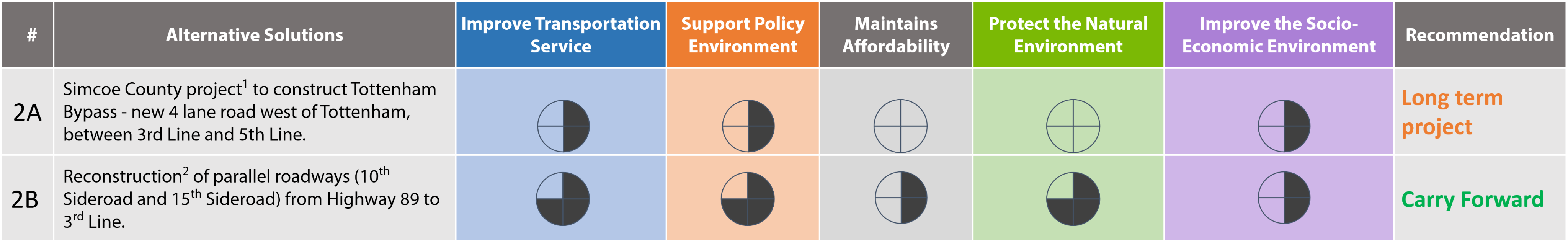
1 Long-term project, beyond 2031 identified in Simcoe County TMP.
2 Road reconstruction typically improves road capacity and/or safety by rebuilding the road base and updating road geometry to current standards if required.
Issue 2: Minimize traffic and trucks passing through Tottenham on Queen Street from 5th Line to 3rd Line.
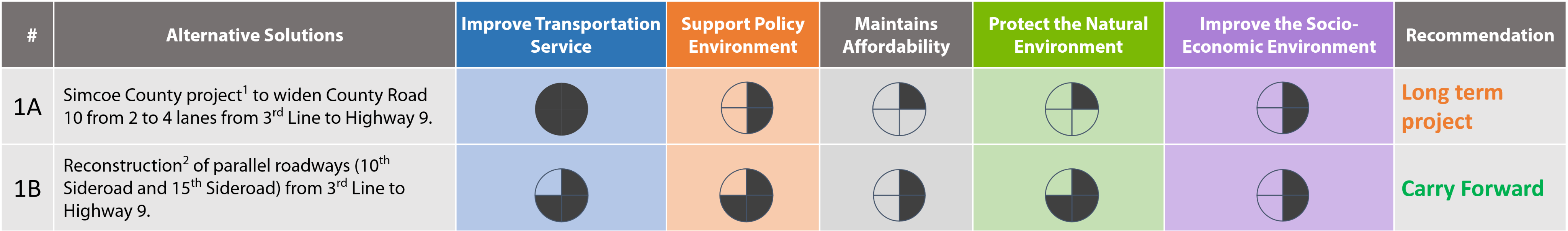
1 Long-term project, beyond 2031 identified in Simcoe County TMP.
2 Road reconstruction typically improves road capacity and/or safety by rebuilding the road base and updating road geometry to current standards if required.
Issue 3: Increasing growth in east-west traffic on Victoria Street in Alliston, from CPR tracks to Sir Frederick Banting Road.
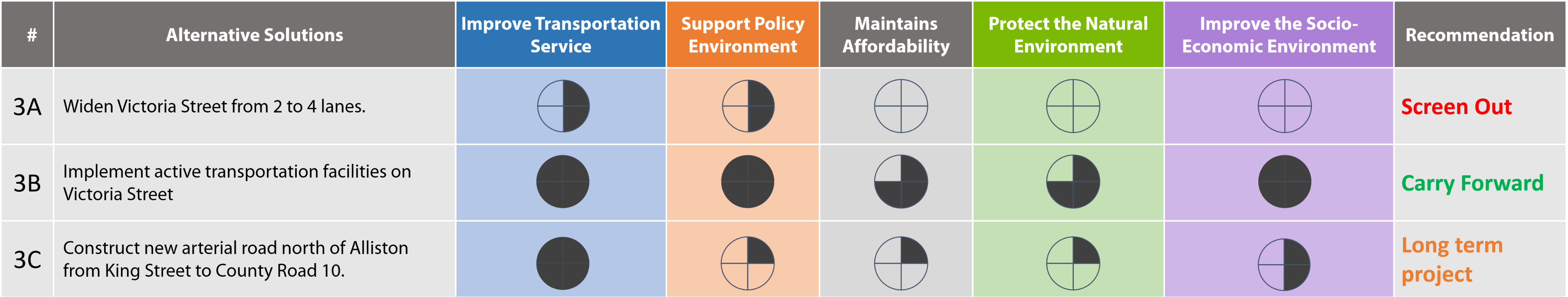
Alternative 3 - Road Network Improvements Evaluation (2 of 2)
Issue 4: Address traffic operations issues at Victoria Street, King Street, and Young Street in Alliston.
1 Long-term project, beyond 2031 identified in Simcoe County TMP.
2 Road reconstruction typically improves road capacity and/or safety by rebuilding the road base and updating road geometry to current standards if required.
Issue 5: Increasing growth in east-west traffic on Highway 89 from Industrial Parkway to New Tecumseth-Innisfil boundary.
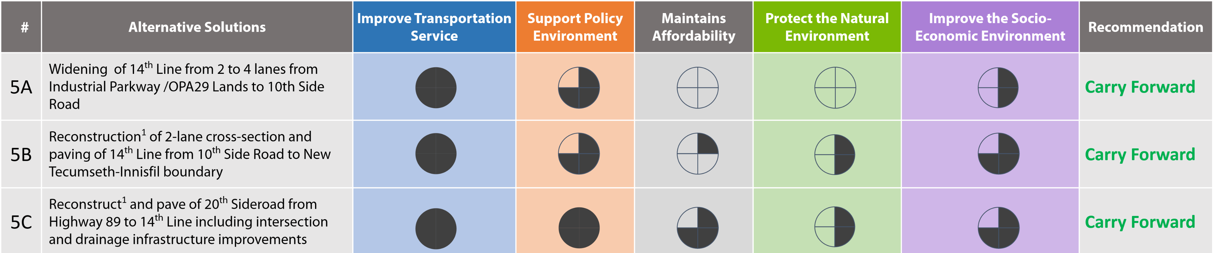
1 Road reconstruction typically improves road capacity and/or safety by rebuilding the road base and updating road geometry to current standards if required.
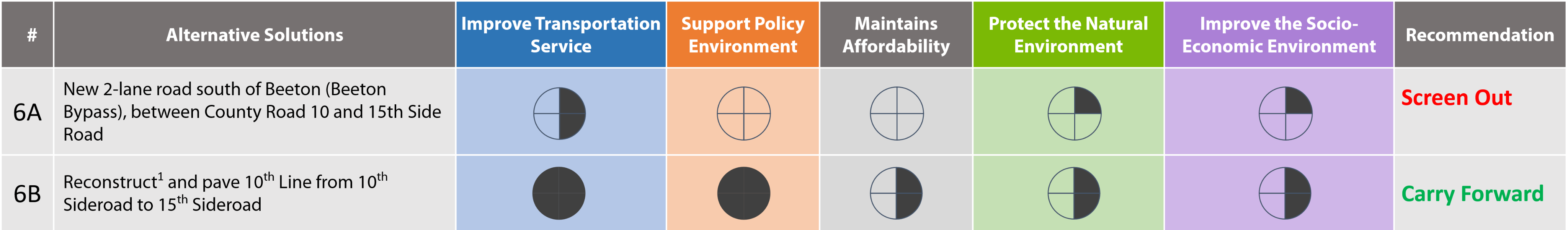
Issue 6: Address traffic operations issues at Victoria Street, King Street, and Young Street in Alliston.
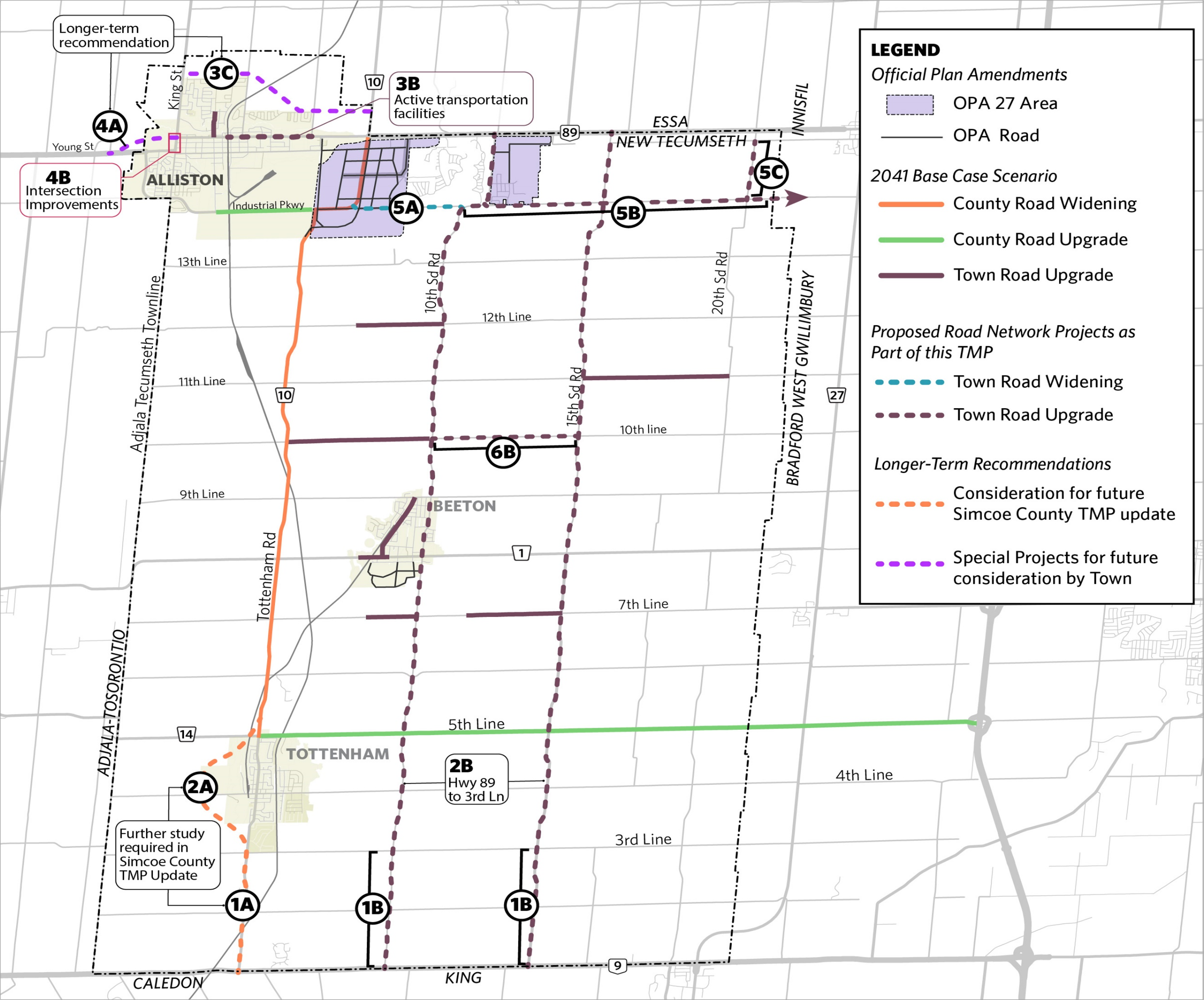
Alternative 3 - Road Network Improvements – Recommended Network*
*Routes shown are conceptual and subject to further study
Click the image below to enlarge.
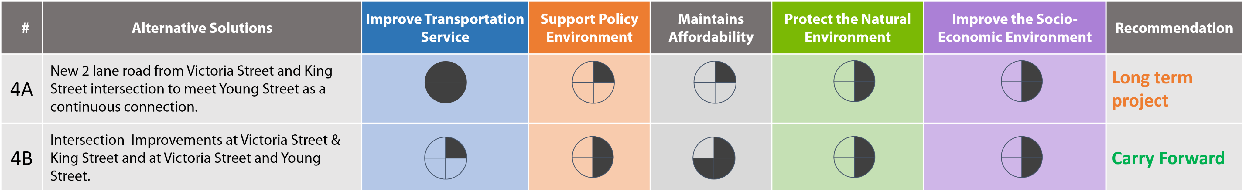
Alternative 4 – Local Traffic Improvements (1 of 3)
In addition to the Town-wide traffic issues, local traffic improvements are needed to improve safety and traffic flow, particularly in Alliston, Beeton and Tottenham.
Alternative 4 – Local Traffic Improvements (2 of 3)
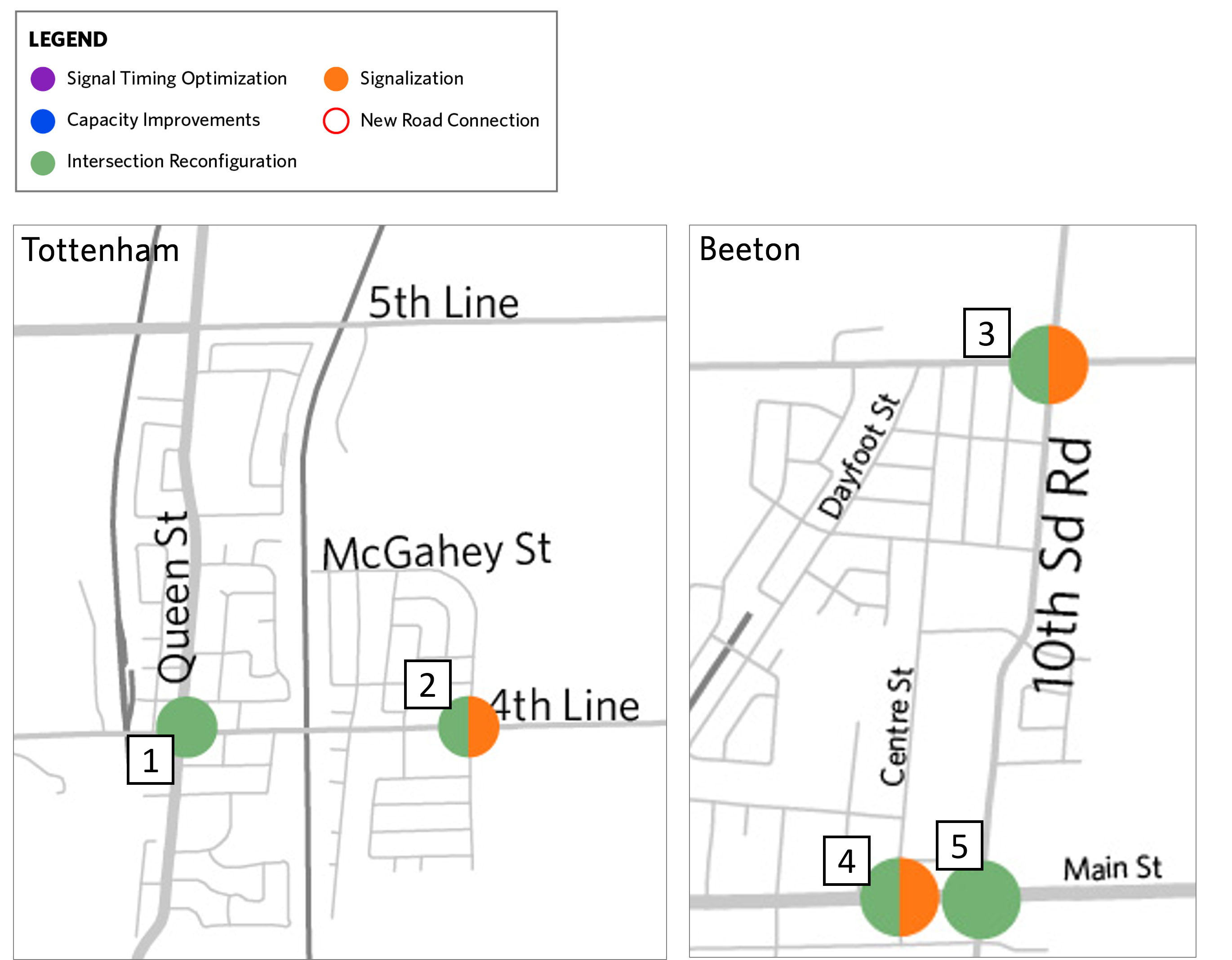
Improvements in Beeton and Tottenham
| Intersection | Existing Conditions | Drivers for Improvement | Proposed Improvements to Consider for Further Study |
|---|---|---|---|
| 1. Queen and 4th Line/Mill Street (Tottenham) | Signalized | Higher rate of collisions, delay | Intersection Reconfiguration |
| 2. 4th Line and McGahey Street / Turner Drive (Tottenham) | McGahey / Turner stop controlled | Queuing / delay | Intersection Reconfiguration / Signalization |
| 3. 9th Line and 10th Side Road (Beeton) | All-way stop | Queuing / delay | Intersection Reconfiguration / Signalization |
| 4. Centre Street and Main Street (Beeton) | Centre Street stop controlled | Queuing / delay | Intersection Reconfiguration / Signalization |
| 5. 10th Side Road and Main Street (Beeton) | Signalized | Higher rate of collisions | Intersection Reconfiguration |
Click the image below to enlarge.
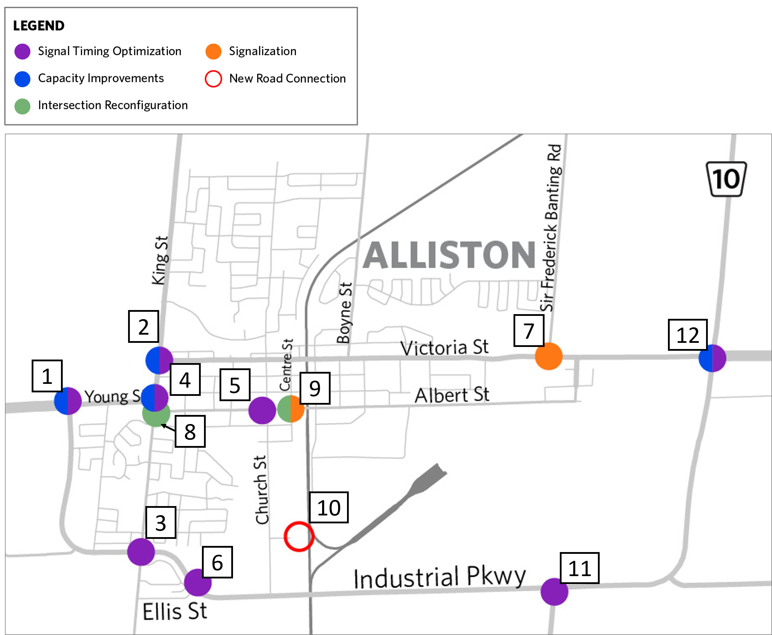
Alternative 4 – Local Traffic Improvements (3 of 3)
Improvements in Alliston
| Intersection | Existing Conditions | Drivers for Improvement | Proposed Improvements to Consider for Further Study |
|---|---|---|---|
| 1. Industrial Pkwy / Young St | Signalized | High delay | Signal Timing Optimization + Additional Capacity |
| 2. King St / Victoria St | Signalized | High delay | Signal Timing Optimization + Additional Capacity |
| 3. Industrial Pkwy / King St | Signalized | Delay | Signal Timing Optimization |
| 4. King St / Young St | Signalized | High delay | Signal Timing Optimization + Additional Capacity |
| 5. Albert St / Church St | Signalized | Delay | Signal Timing Optimization |
| 6. Industrial Pkwy / Ellis St | Signalized | Delay | Signal Timing Optimization |
| 7. Victoria St / Sir Frederick Banting Road | Sir Frederick Banting Road stop controlled | Delay | Signalization |
| 8. King / Albert Frederick Banting Road | Albert Street stop controlled | Delay | Intersection Reconfiguration |
| 9. Albert / Centre | Centre Street stop controlled | Delay | Intersection Reconfiguration / Signalization |
| 10. New road from Dufferin Street to Alderson Court | No connection across railway | Connectivity | New road to provide alternate access for commercial/industrial land uses on Dufferin St |
| Simcoe County Intersections | Existing Conditions | Drivers for Improvement | Proposed Improvements to Consider for Further Study |
|---|---|---|---|
| 11. Industrial Pkwy / Tottenham Rd | Signalized | High delay | Signal Timing Optimization |
| 12. Victoria St / Industrial Parkway | Signalized | High delay | Signal Timing Optimization + Additional Capacity |
Click the image below to enlarge.
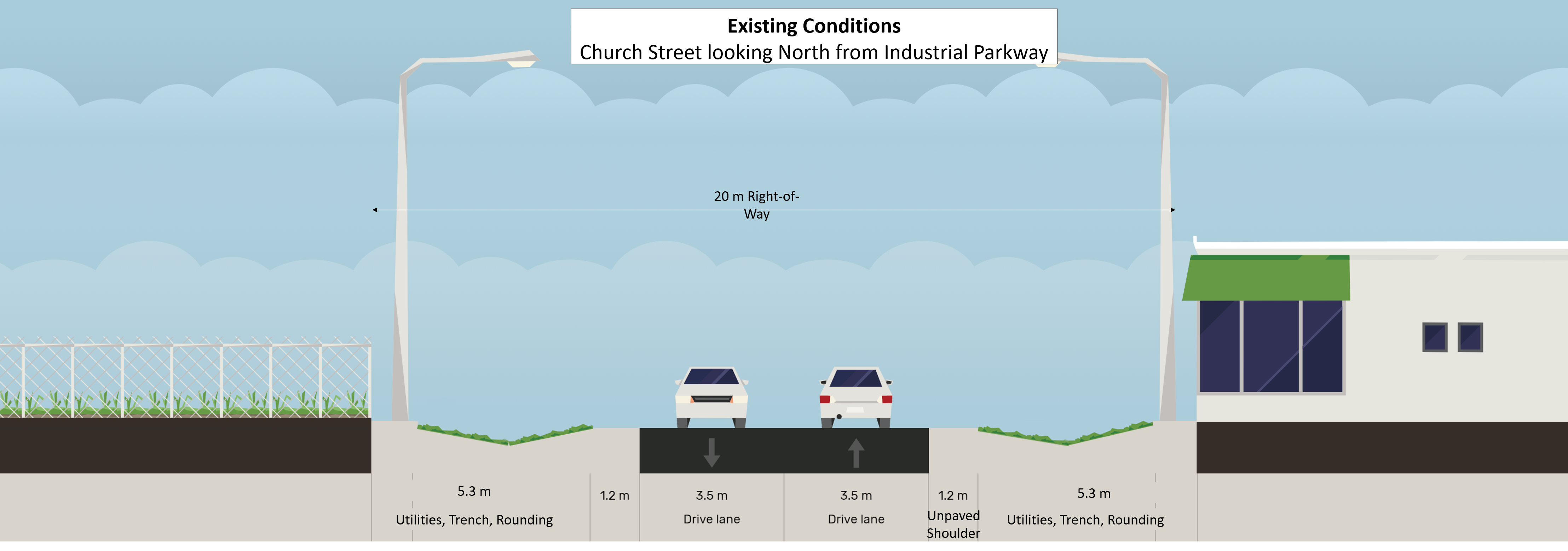
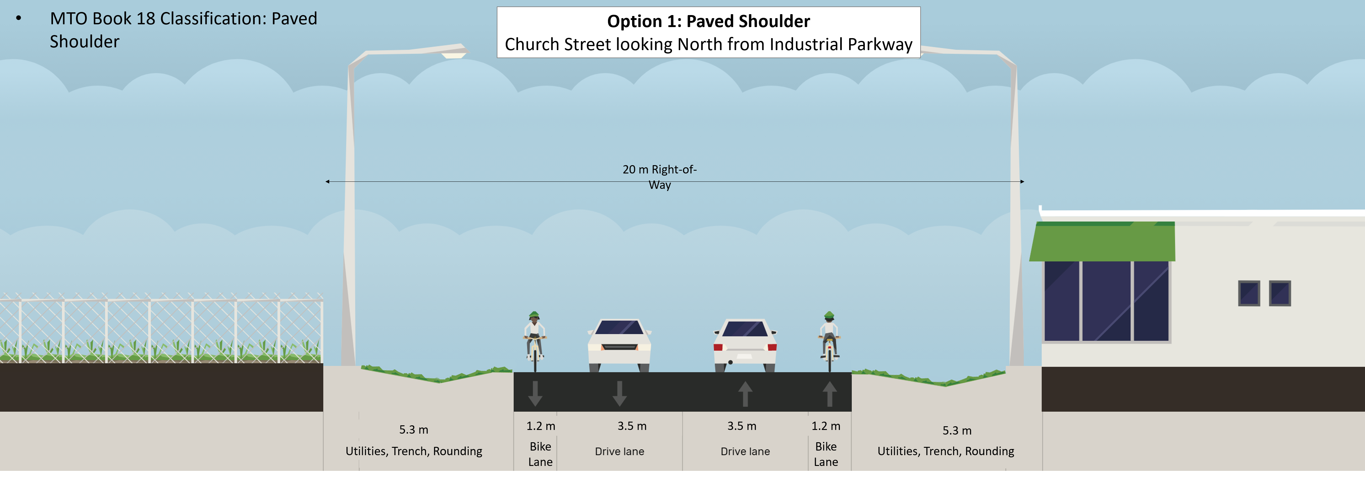
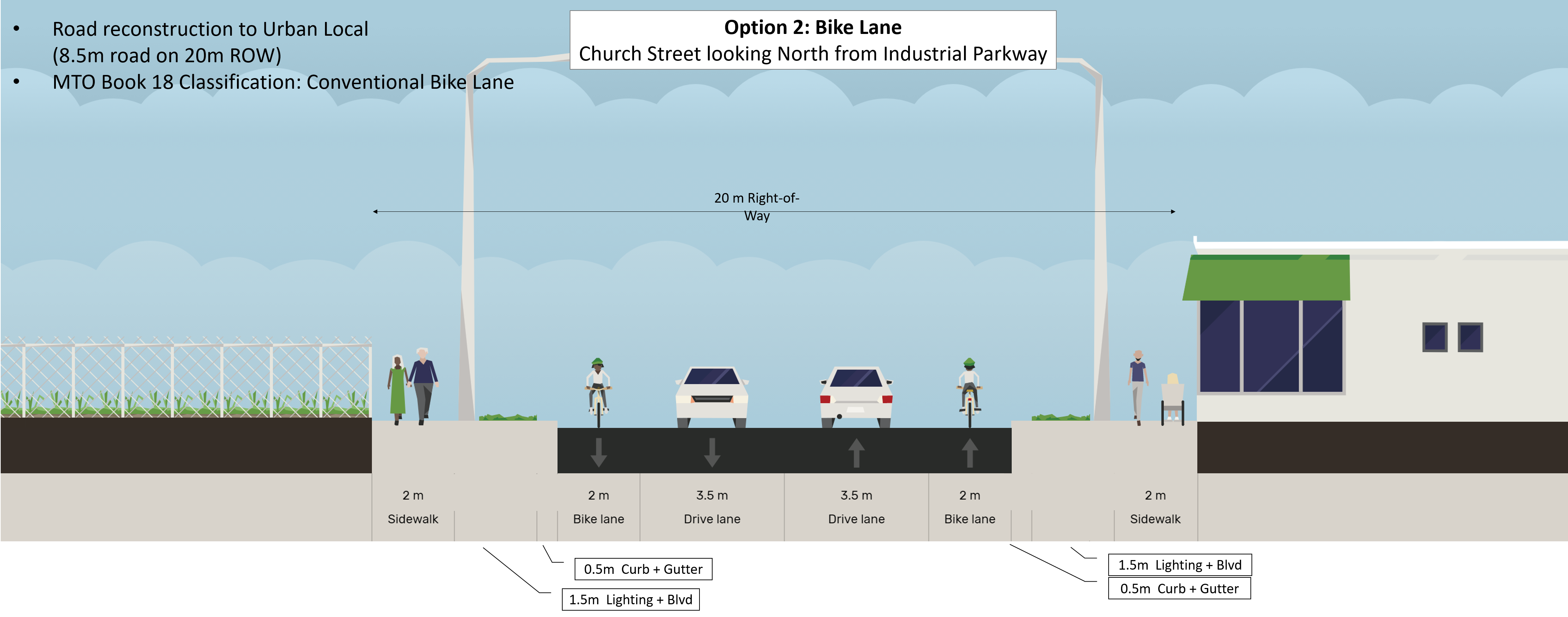
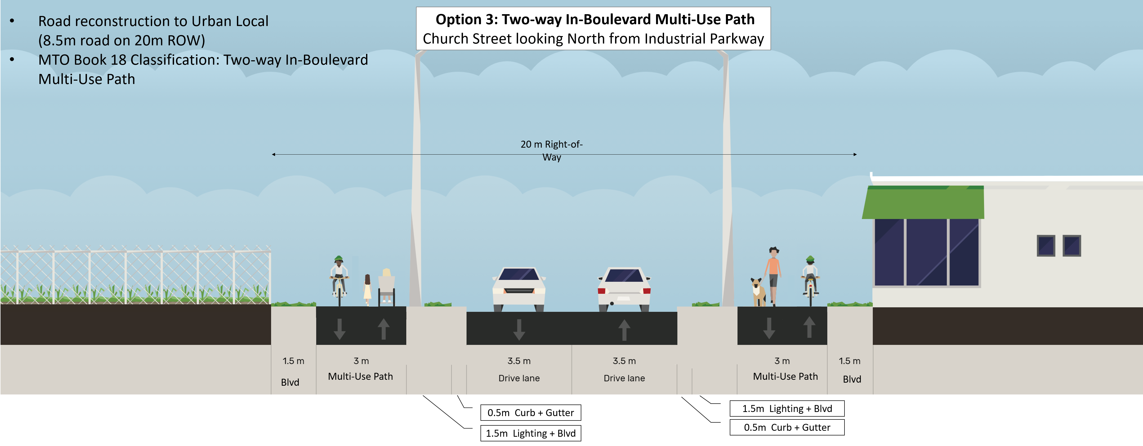
Complete Streets (1 of 2)
Part of this TMP Study includes exploring ways the Town can implement Complete Streets principles. Complete Street are streets that are designed to be safe for all users, including people who walk, cycle, take transit, or drive. The goal is to improve accessibility, safety, and comfort for road users of all ages and abilities while respecting the context of the street and surrounding land uses. The following cross sections illustrate several options on how Church Street (from Industrial Parkway to Beech Street), which is part of the Proposed Active Transportation Network, could be reconstructed to accommodate cyclists and/or pedestrians
Click the image below to enlarge.
Complete Streets (2 of 2)
Click the image below to enlarge.
Transportation Policies (1 of 2)
The Town’s TMP Study will also be developing policy recommendations which will provide guidance on transportation decisions in multiple areas. Which policies are you most interested in? Provide your feedback in the comment box at the bottom of the next page.
Active Transportation and Transit Supportive Policies: Active Transportation and Transit Supportive policies aim to make active transportation and transit more attractive as a mode of transportation. These may include policies that aim to improve infrastructure and facilities such as sidewalks, cycle lanes, bike parking, bus shelters and bus stop upgrades. This TMP will include a policy framework that identifies where active transportation and transit supportive policies can be applied across the Town’s existing policy areas.
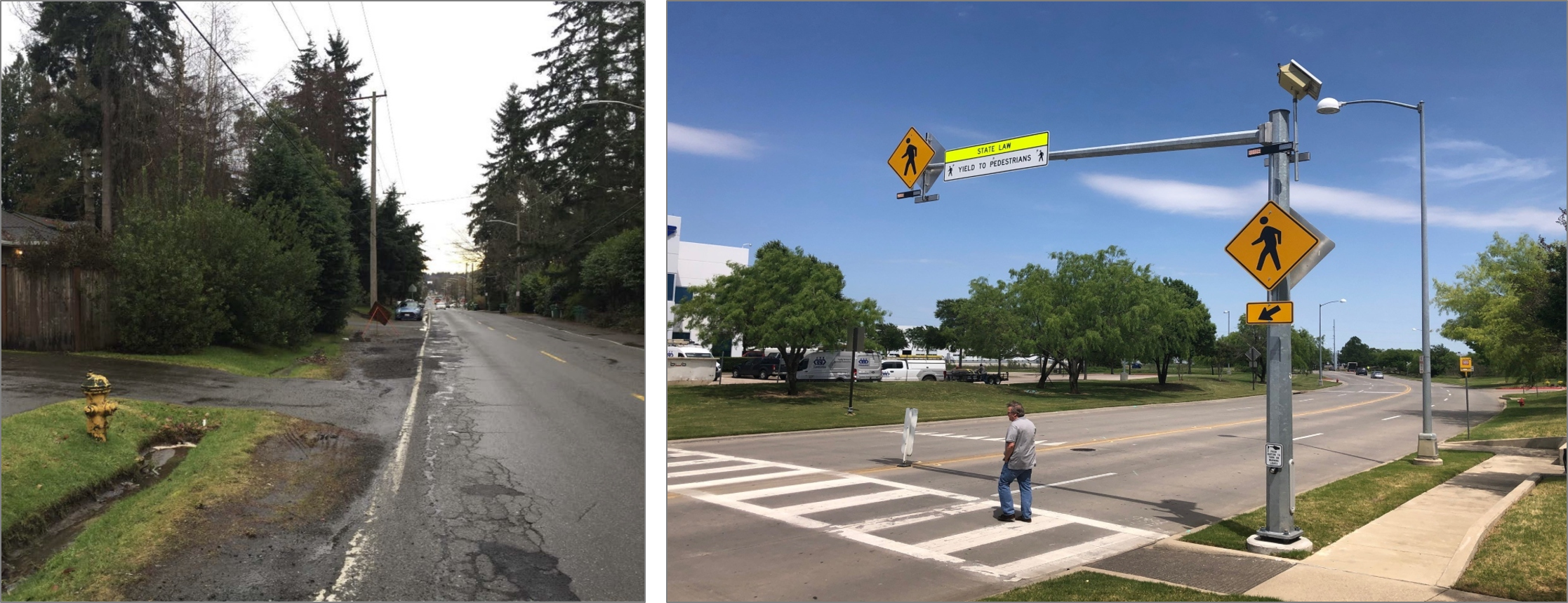
Sidewalk Prioritization: A Sidewalk Prioritization policy seeks to prioritize in-fill of gaps in the sidewalk network, including cross-walks, to complete the pedestrian network in a cost-effective manner. This TMP will include an evaluation framework to identify priority sidewalks based on existing conditions, accessibility, land use connectivity, road type, public support and cost.
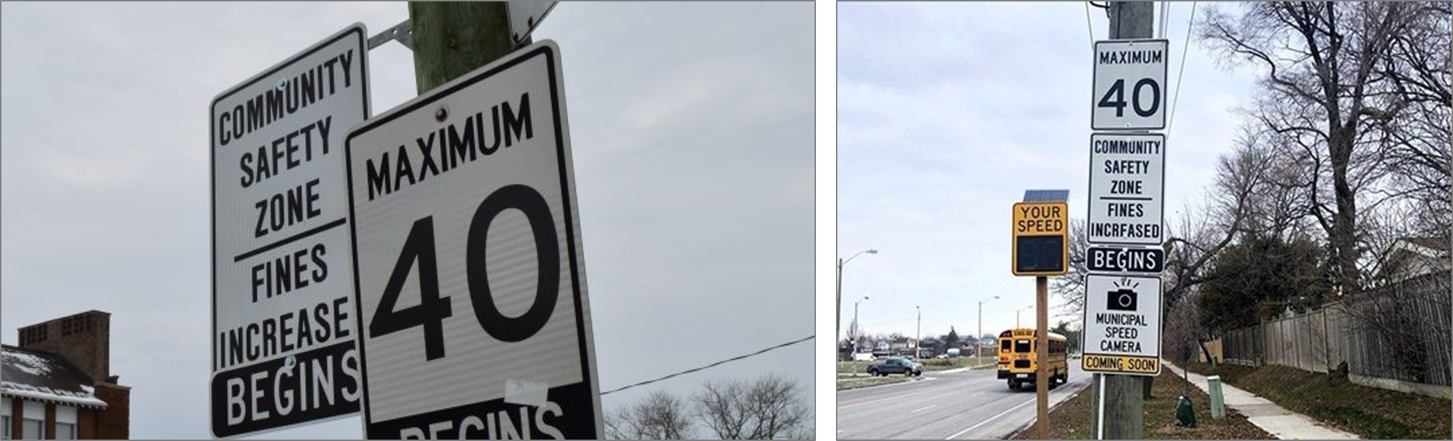
Community Safety Zone Policy: A Community Safety Zone is a designated area marked with community safety zone signs that are recognized under provincial legislation and allows the doubling of fines associated with speeding within the Zone. Community Safety Zones are typically implemented for schools, community centres, parks, retirement homes, or roadway sections with high collision rates. This TMP will include a policy framework that identifies where community safety zones can be implemented.
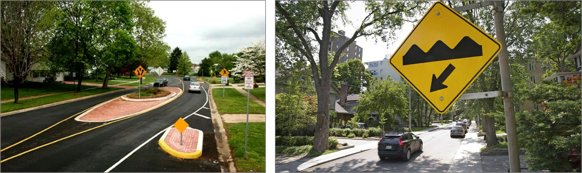
Traffic Calming: Traffic calming uses physical design and other measures to improve safety for motorists, pedestrians and cyclists by managing speed and traffic volumes on neighbourhood streets. This TMP will include a traffic calming policy and process for applying traffic calming within New Tecumseth.
Transportation Policies (2 of 2)
The Town’s TMP Study will also be developing policy recommendations which will provide guidance on transportation decisions in multiple areas. Which policies are you most interested in? Provide your feedback in the comment box (below).
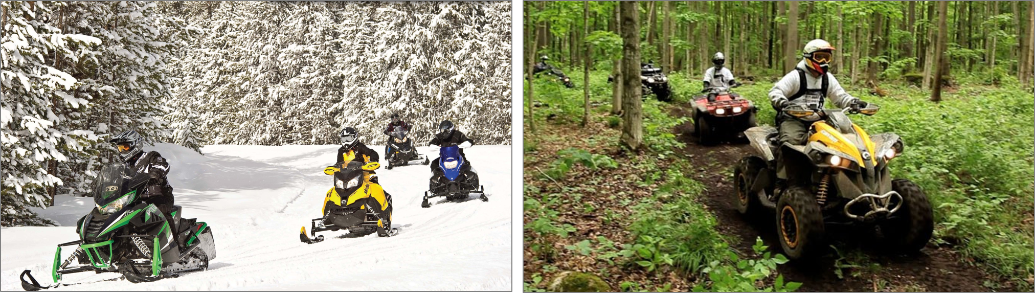
Managing Off-Road Vehicles: Off-Road Vehicles such as All-Terrain Vehicles (ATVs), snowmobiles, and dirt bikes are year-round and recreational vehicles. The TMP will incorporate the Town’s existing ATV Off-Road Vehicles By-Law and provide recommendations on the policy framework where appropriate. Aspects such as trail type, location, characteristics and connectivity will be included.
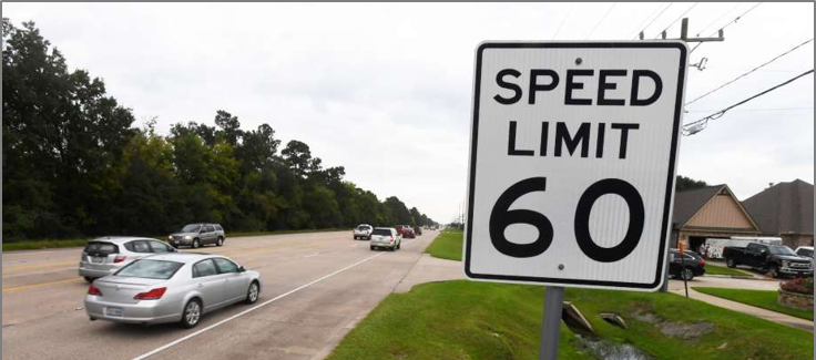
Speed Limit: A Speed Limit policy aims to improve mobility, safety and security for all users. This TMP will include a policy framework that identifies the appropriate speed limit for each roadway segment in the Town’s road network. Aspects such as existing road conditions, developments, pedestrian and cycling activity, speed limits on adjoining segments, and collision data will inform the framework. This will be done in coordination with the Community Safety Zone Policy
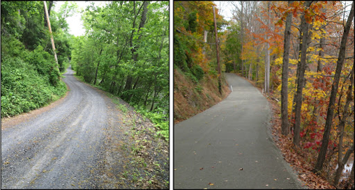
Gravel Road Upgrades: The Town currently has a Gravel Road Upgrade policy that establishes a process by which Gravel Roads are prioritized for upgrades. The TMP will review and make recommendations for updates to the policy that include a complete streets approach.