 MENU
MENU
Welcome to Public Information Centre No. 2
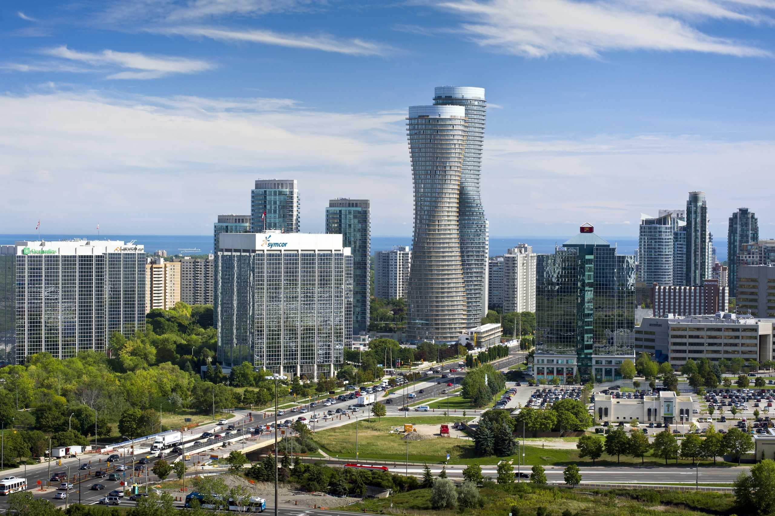
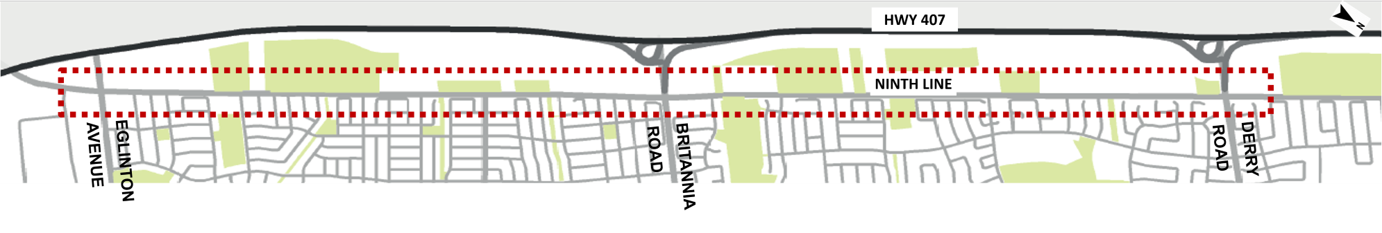
Ninth Line Improvements Eglinton Avenue West to Derry Road West
Welcome to the second Public Information Centre (PIC No.2) for the Ninth Line Environmental Assessment (EA) Study.
The commenting period for PIC No. 2 will be open from January 13th to February 3rd, 2021. Comments can also be emailed to Jeffrey.Reid@mississauga.ca.
We look forward to hearing from you and receiving your input on this study.
How to Navigate
- Click on the arrows on the right side of your screen
- Use the navigation bar at the left of your screen to revisit any part of the meeting
- Scoll up and down to see the entire slide on each slide
- Click on "Play Audio" located on the top right corner on each slide to play audio presentation of each slide
How to Participate
- Click the arrows in the green bars on the left and right of the screenin the gray bars on the bottom of the page to get started learning about the project. Some slides will have areas where you can provide your feedback on the information shown in the slide
- Provide a comment at any point by clicking the "Comment" button at the top right corner of your screen. Once finished, please make sure to hit "Submit" to send your comments to the project team.
Contact Information
Information will be collected in accordance with the Freedom of Information and Protection of Privacy Act. With the exception of personal information, all comments will become part of the public record.
Project Objectives
Study Purpose
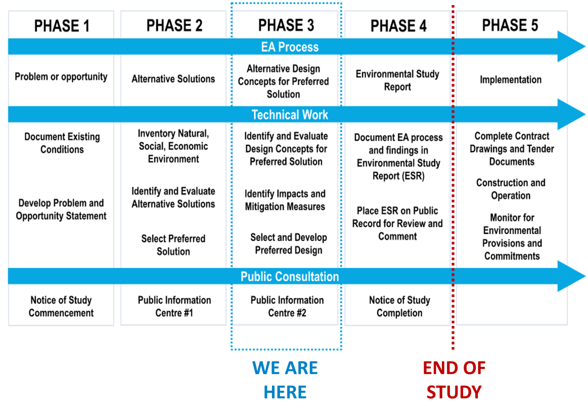
EA Study Process
An Environmental Assessment (EA) is a planning and approval process for municipal infrastructure projects, following Ontario's Environmental Assessment Act. There are five phases and we are currently in Phase 3 - Alternative Design Concepts for the Preferred Solution. Public Consultation is a key component of the EA process.
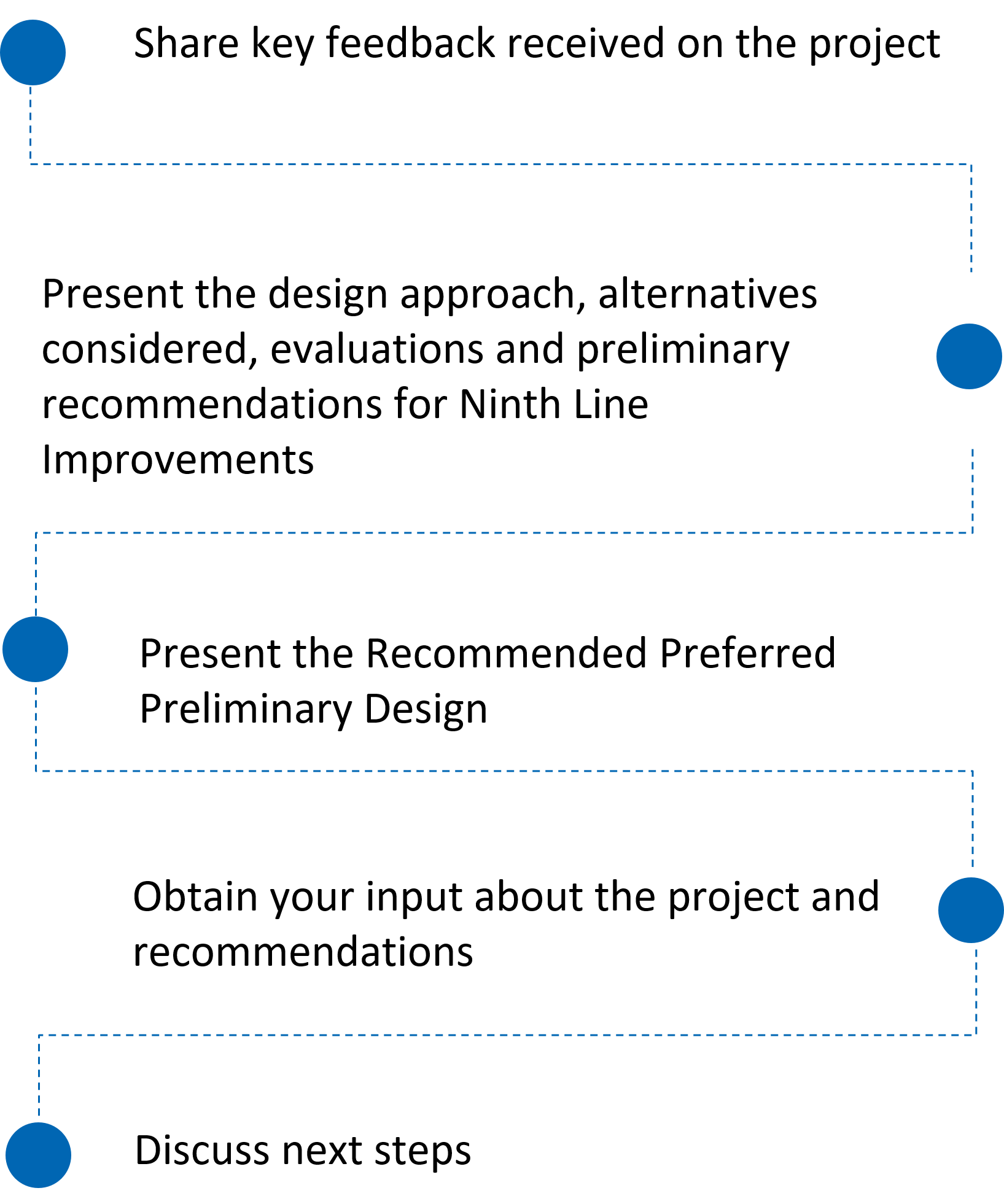
Why Are We Here?
This purpose of PIC No. 2 is to:
What we heard at Public Information Centre No. 1
Top areas of interest we heard in PIC No. 1 include:
Increase road capacity and reduce travel times
Improve walking and cycling by providing facilities (separated and off-road)
Additional pavement width will increase runoff
Consider public realm enhancements as part of transportation improvements
Improve efficiency and safety at intersections
Preserve the natural environment and wildlife
Concerns due to future growth and associated construction
Infrastructure is not supporting the growth and should be completed before development occurs
Engagement Strategies
Some ways we reached out to obtain input throughout the study include:
Question: How did you hear about PIC No. 2? Please list all that apply (for example: mailed postcard, City Social Media, newspaper advertisement, project team email, word of mouth, etc.)
Preferred Solution
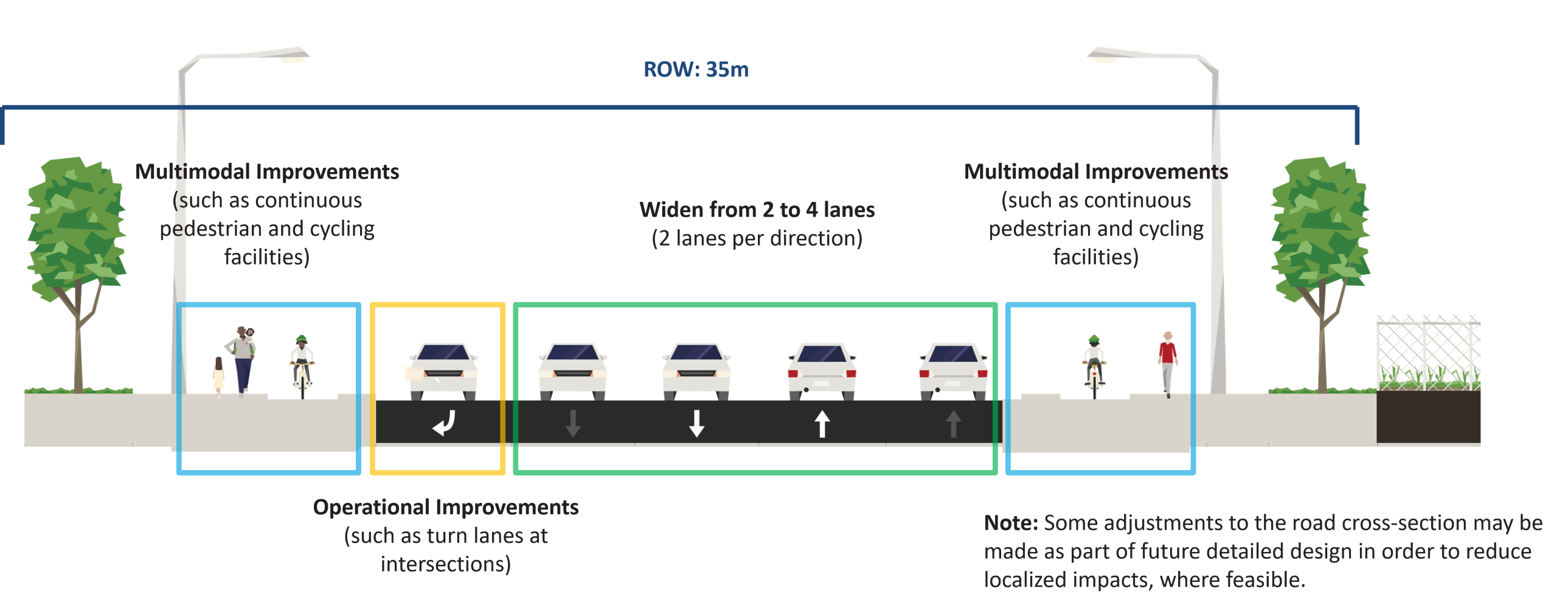
Following PIC No. 1 the Preferred Solution for the Ninth Line Improvements between Eglinton Avenue West and Derry Road West was confirmed. The Preferred Solution is consistent with Mississauga's Transportation Master Plan and Shaping Ninth Line Study and includes:
Evaluation Criteria for Alternative Design Concepts
The Alternative Design Concepts were evaluated based on the following criteria.
Transportation
- Addresses Congestion and Improves Corridor Capacity and Vehicular Level of Service to Accommodate Future Travel Demand
- Accommodates All Road Users, Including Pedestrians, Cyclists and Transit Users
- Enhanced Road Safety and Comfort for All Road Users
- Accommodates Commercial Goods Movement
- Improved Access to / from Ninth Line
- Addresses Problem / Opportunity Statement
- Improves Network Connectivity
- Improves Emergency Response Time
Natural Heritage
- Minimizes Impacts to and Enhances Environmentally Sensitive Areas
- Minimizes Impacts to Wildlife, Vegetation, Aquatic Species and Habitat, and Species at Risk
- Provides Drainage and Stormwater Management Improvements and Mitigates Erosion
- Minimizes Effects on Climate Change
Socio-Economic
- Improves Attractiveness/Aesthetics
- Minimizes Business Impacts and Enhances Business and Place-Making Opportunities
- Minimizes Property Acquisition
- Minimizes Noise and Vibration Impacts
- Improves Air Quality
- Provides or Improves Streetscape Amenities and Urban Design Elements
Cultural Heritage
- Minimizes Impacts to Archaeological Features
- Minimizes Impacts to Cultural Heritage Resources
City Building
- Consistent With The City's Strategic Priorities Pursuant to the City's Strategic Plan 'Our Future Mississauga', Official Plan Policy
- Meeting Objectives, the Cycling Master Plan, Shaping Ninth Line, and Other Relevant Planning Documents
- Accommodates Existing and Planned Development
Engineering, Construction Complexity and Implementation
- Minimizes Utility Relocation
- Addresses Drainage or Contamination Concerns
- Minimizes Construction Complexity, Including Staging and Traffic Disruption During Construction
- Optimizes Capital Costs
- Optimizes Operation/Maintenance Costs
- Minimizes Property Acquisition Costs
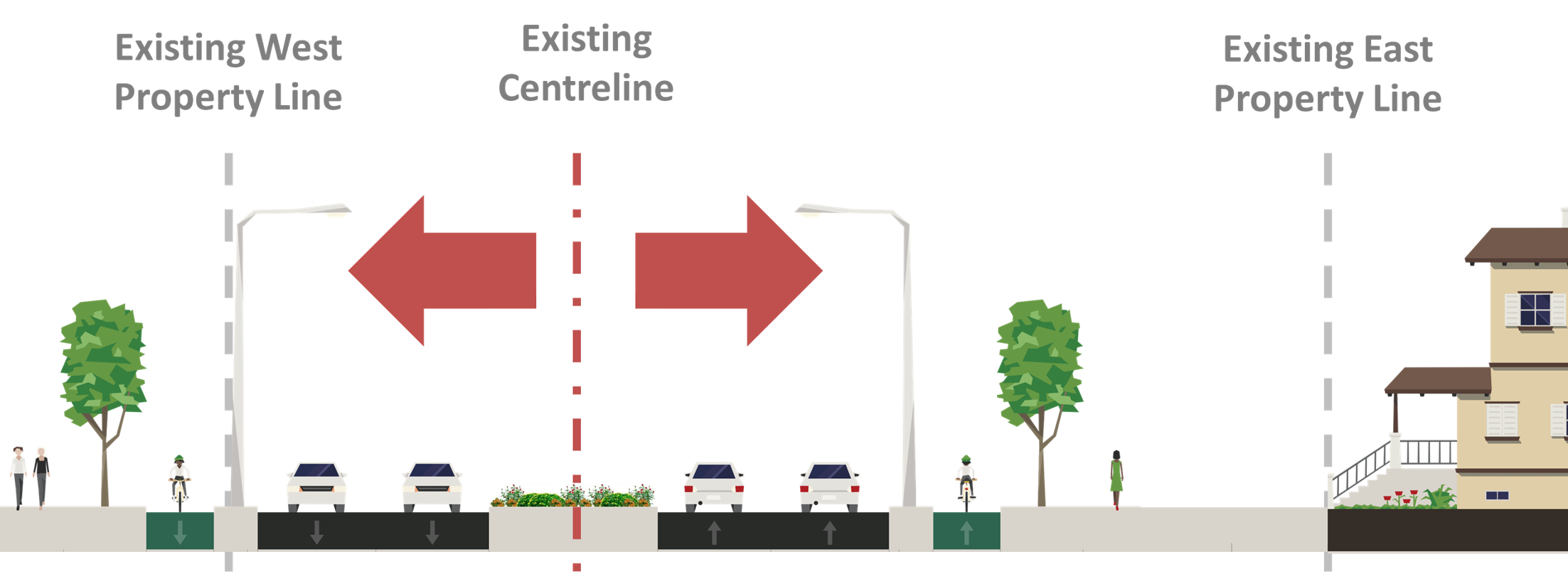
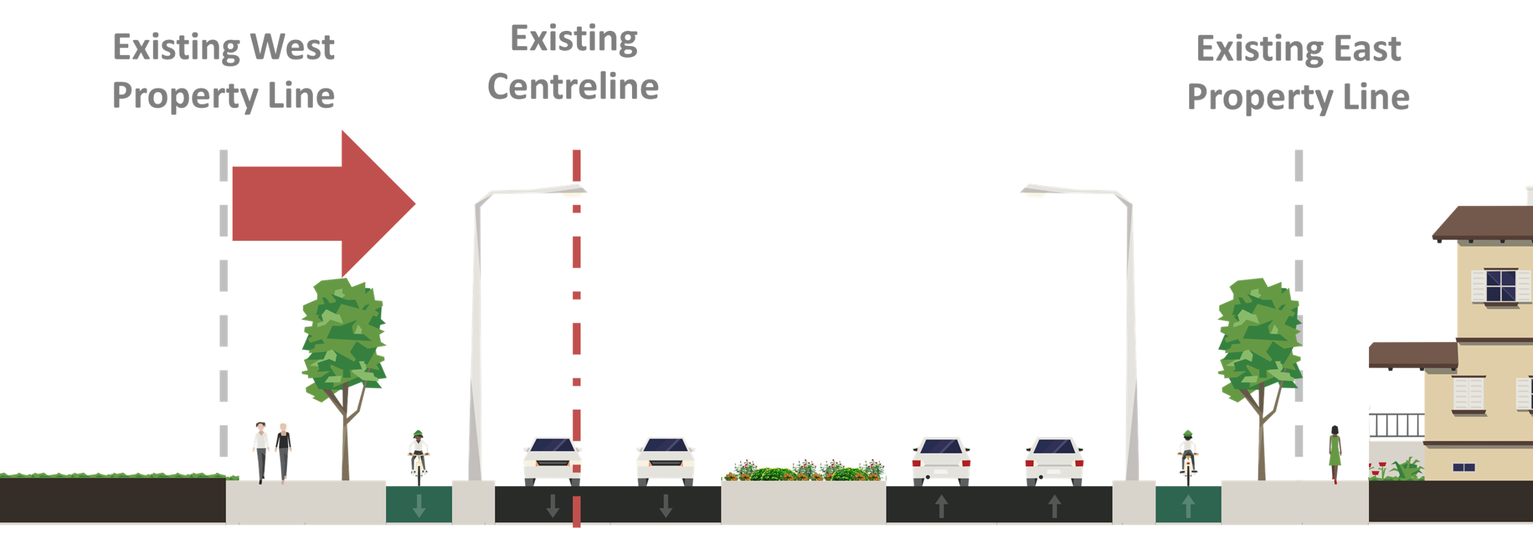
Alternative Design Concepts - Road Widening
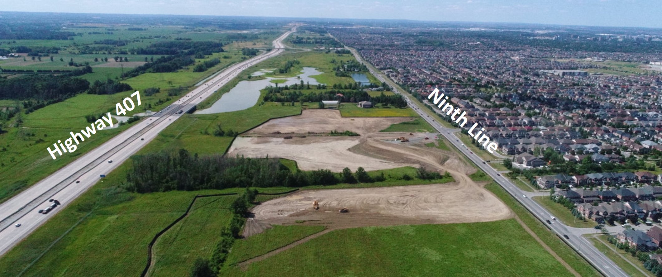
The following alternative design concepts were considered to widen Ninth Line from two lanes to four lanes to obtain the City of Mississauga's Official Plan of 35m right-of-way (ROW)
Road Widening Alternatives
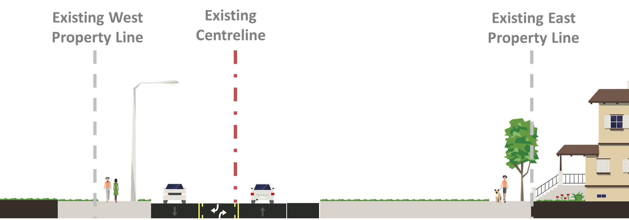
Current Condition
- Two (2) lanes (one in each direction) with a continuous centre left-turn lane
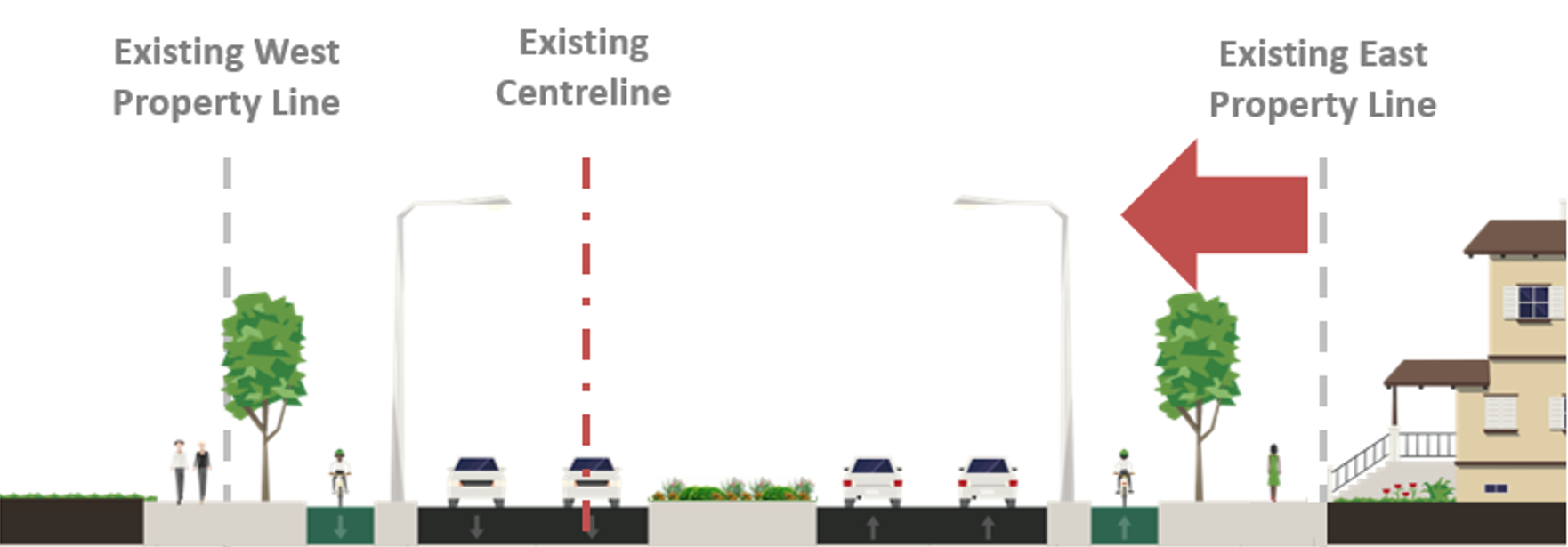
Alternative 1 – Widen to West
- Widen from two (2) to four (4) lanes from the existing east property line so associated impacts occur on the west side
- Obtain 35m ROW from the west side
- Moderate shift of the Ninth Line roadway to the east side
Alternative 2 – Widen about the Centreline
- Widen from two (2) to four (4) lanes from the existing centreline
- Obtain 35m ROW from the west side
- Minor shift of the Ninth Line roadway to the east side
Alternative 3 – Widen to East
- Widen from two (2) to four (4) lanes from the existing west property line so associated impacts occur on the east side
- Obtain 35m ROW from the east side
- Significant shift of the Ninth Line roadway to the east side
Evaluation and Recommendations
|
Alternative 1
Widen to West |
Alternative 2
Widen about the Centreline |
Alternative 3
Widen to East |
|
|---|---|---|---|
| Transportation and Transit, Accessibility |
Preferred
|
Preferred
|
Preferred
|
| City Building |
Preferred
|
Less Preferred
|
Not Preferred
|
| Natural Heritage |
Less Preferred
|
Less Preferred
|
Preferred
|
| Socio-Economic Environment |
Preferred
|
Less Preferred
|
Not Preferred
|
| Cultural Heritage |
Less Preferred
|
Not Preferred
|
Preferred
|
| Engineering Considerations, Construction Complexity, and Implementation |
Less Preferred
|
Preferred
|
Not Preferred
|
| Overall Evaluation | Recommended |
- It minimizes impacts to existing properties on the east side
- Planned developments on the west can accommodate property impacts through development applications
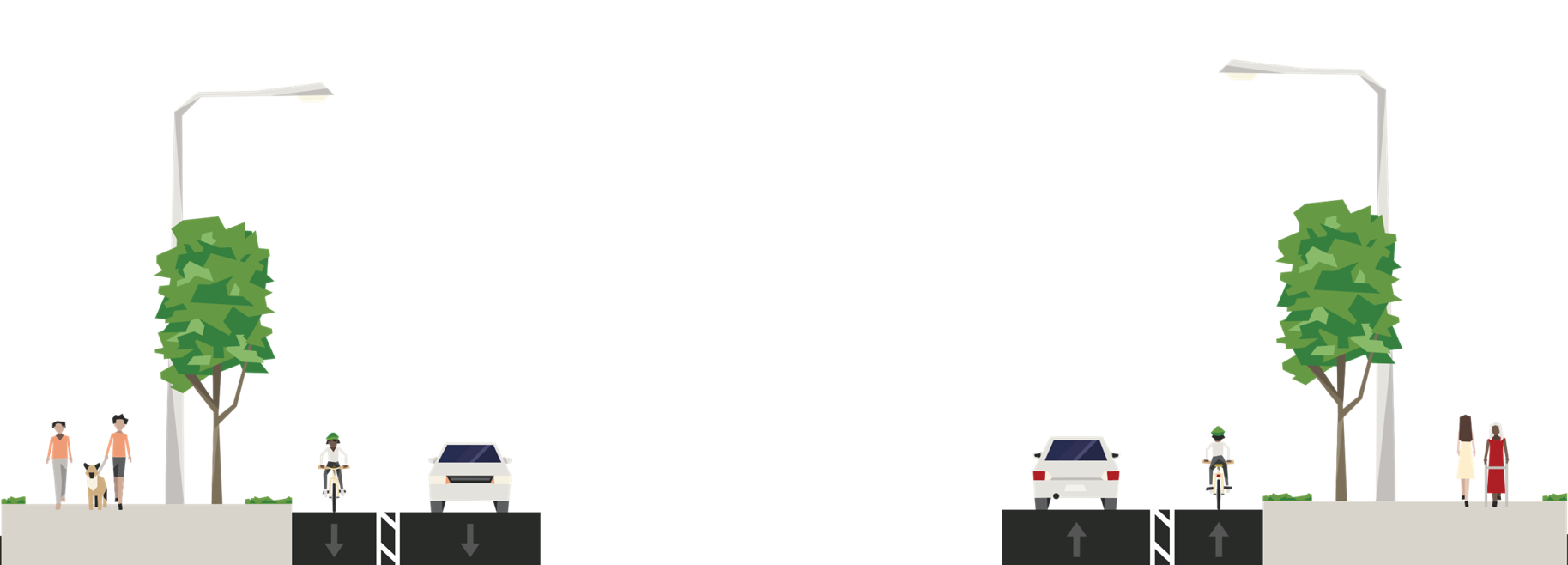
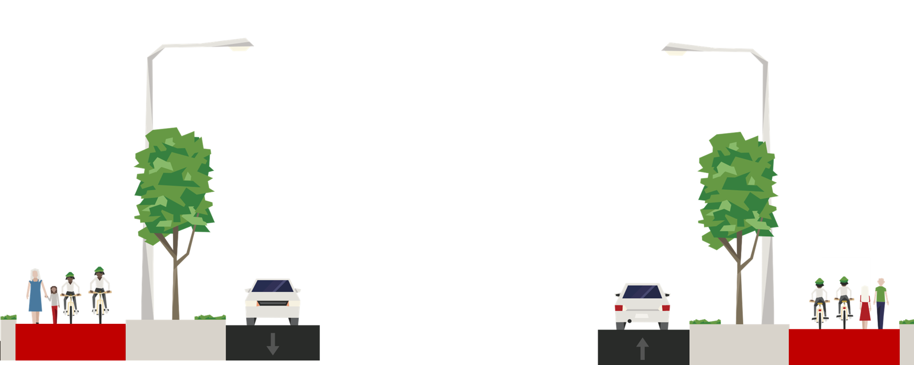
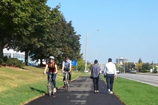
Alternative Design Concepts - Active Transportation
The following alternative design concepts were considered to determine how to best accommodate pedestrians and cyclists along Ninth Line.
Active Transportation Alternatives
Alternative 1
- On-Street Bike Lanes with buffer on both sides; cyclists travel in one direction (in the same direction as vehicle traffic)
- Sidewalk on both sides
- Opportunities for landscaping in the boulevard
Alternative 2
- Separated Boulevard Cycle Tracks on both sides; cyclists travel in one direction (in the same direction as vehicle traffic)
- Sidewalk on both sides
- Opportunities for landscaping in the boulevard

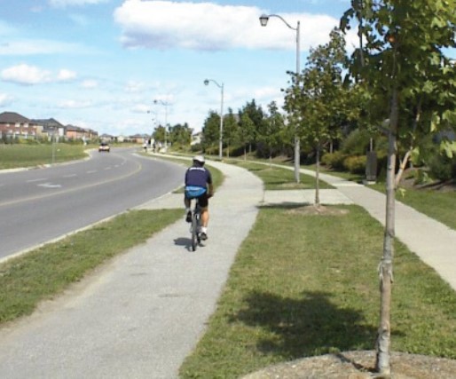
Alternative 3
- Multi-use Paths (MUP) on both sides provide shared space for pedestrians and cyclists to travel in both directions
- Opportunities for landscaping in the boulevard
Evaluation and Recommendations
|
Alternative 1
On-Street Bike Lanes with Buffer and Sidewalks |
Alternative 2
Boulevard Cycle Tracks and Sidewalks |
Alternative 3
Multi-Use Paths |
|
|---|---|---|---|
| Transportation and Transit, Accessibility |
Not Preferred
|
Preferred
|
Not Preferred
|
| City Building |
Preferred
|
Preferred
|
Preferred
|
| Natural Heritage |
Preferred
|
Preferred
|
Preferred
|
| Socio-Economic Environment |
Less Preferred
|
Less Preferred
|
Preferred
|
| Cultural Heritage |
Preferred
|
Preferred
|
Preferred
|
| Engineering Considerations, Construction Complexity, and Implementation |
Less Preferred
|
Less Preferred
|
Preferred
|
| Overall Evaluation | Recommended |
- It separates pedestrians from cyclists within the boulevard to minimize conflicts
- Boulevard cycle tracks are provided in one direction on both sides and are separated from vehicles/trucks
- It provides continuous and separated facilities throughout the corridor
- It provides landscaping opportunities between cycle tracks and sidewalks
Intersection Control
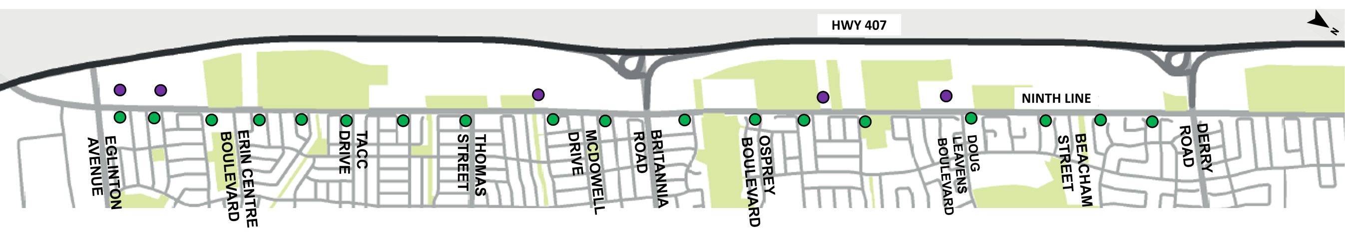
Traffic Signals
A review of existing and future traffic operations identified the need for new traffic signals . Three new traffic signals are warranted in the corridor and are proposed at the Ninth Line intersections of Tacc Drive, McDowell Drive and Beacham Street.
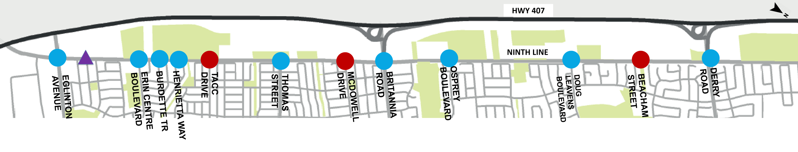
 Existing Intersection with Traffic Signal
 Proposed Intersection with Traffic Signal
 Potential Traffic Signal due to Future Development (to be confirmed through development review process)
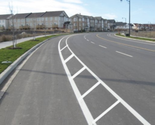
Roundabouts
All existing and proposed signalized intersections along the Ninth Line corridor were considered for roundabouts.
- Circular Intersection Control
- Drivers travel around a centre island
- No traffic signals
Several safety benefits
- Speed Management
- Elimination of "Beating the Light"
- One-way travel and reduction of angle collisions
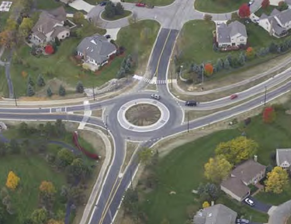
An assessment was completed and concluded that roundabouts are not recommended along the Ninth Line Corridor for the following reasons:
Preferred Preliminary Design Concept
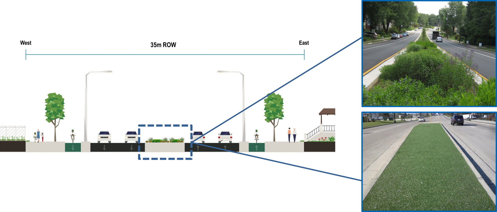
Preferred Design Concept Typical Section
- Widen from two lanes to four lanes
- Boulevard Cycle Tracks and Sidewalks on both sides
- New Traffic Signals, Crossrides at intersections for pedestrians and cyclists
- Urbanization, Streetscaping and Landscaping Opportunities
- Structural Modification(s) / Replacement at Watercourse Crossings
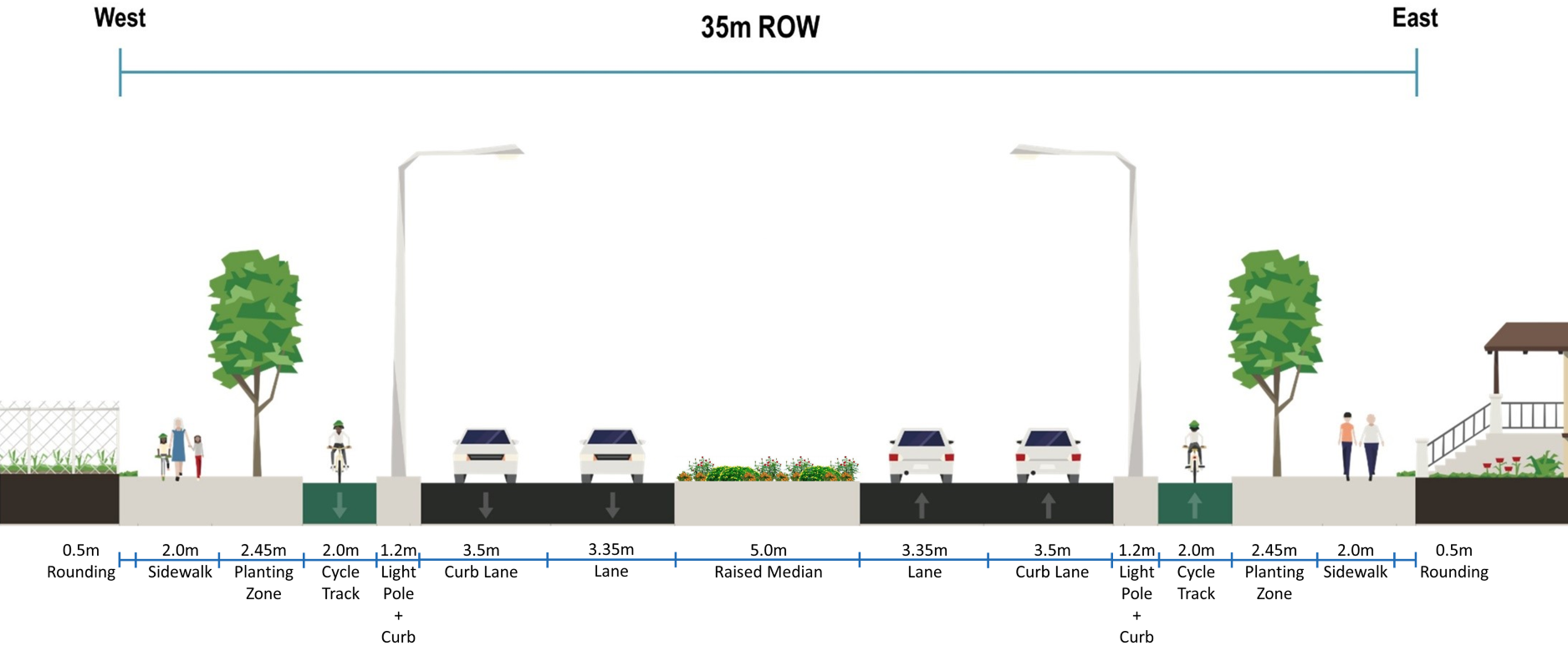
Preferred Preliminary Design Concept (continued)
Noise Impacts and Mitigation
A Noise Assessment was conducted to determine the noise levels from future traffic along Ninth Line between Eglinton Avenue West and Derry Road West.
- As a result of Ninth Line widening and decreased posted speed from 70km/h to 60km/h, the threshold for future noise is met on the east side of Ninth Line.
- Future noise levels are highest on the west side of Ninth Line, due to Highway 407. Future noise levels to be address through development review process.
 Noise Sensitive Receptor (less than 60 dBA)
 Noise Sensitive Receptor (between 60-62 dBA)
Watercourse Crossings
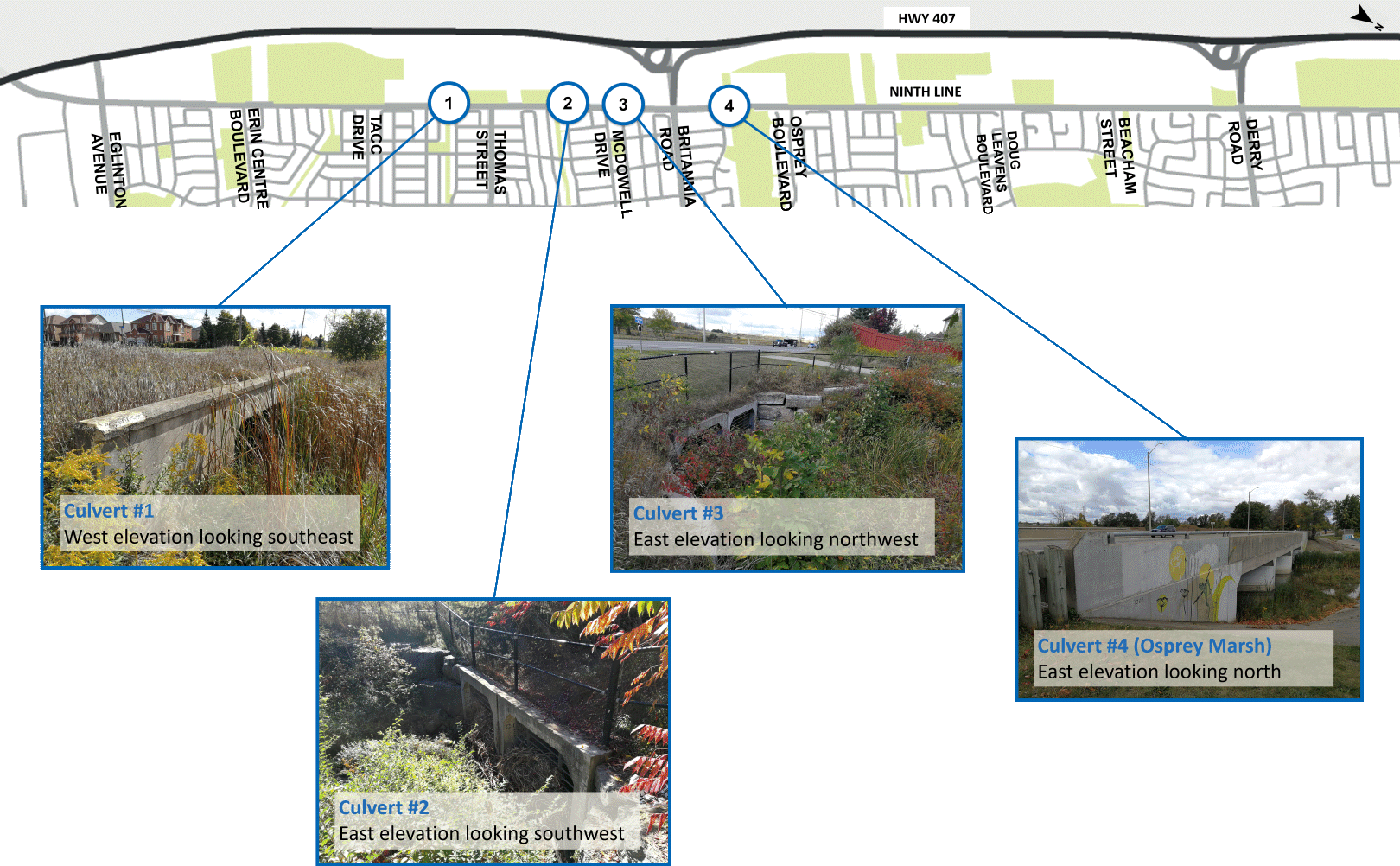
Preferred Preliminary Design Concept (continued)
Centre Median Treatments
Centre median planting areas are identified at select locations where a 5.0m raised median is proposed along Ninth Line.
Intersection Crossing Treatments
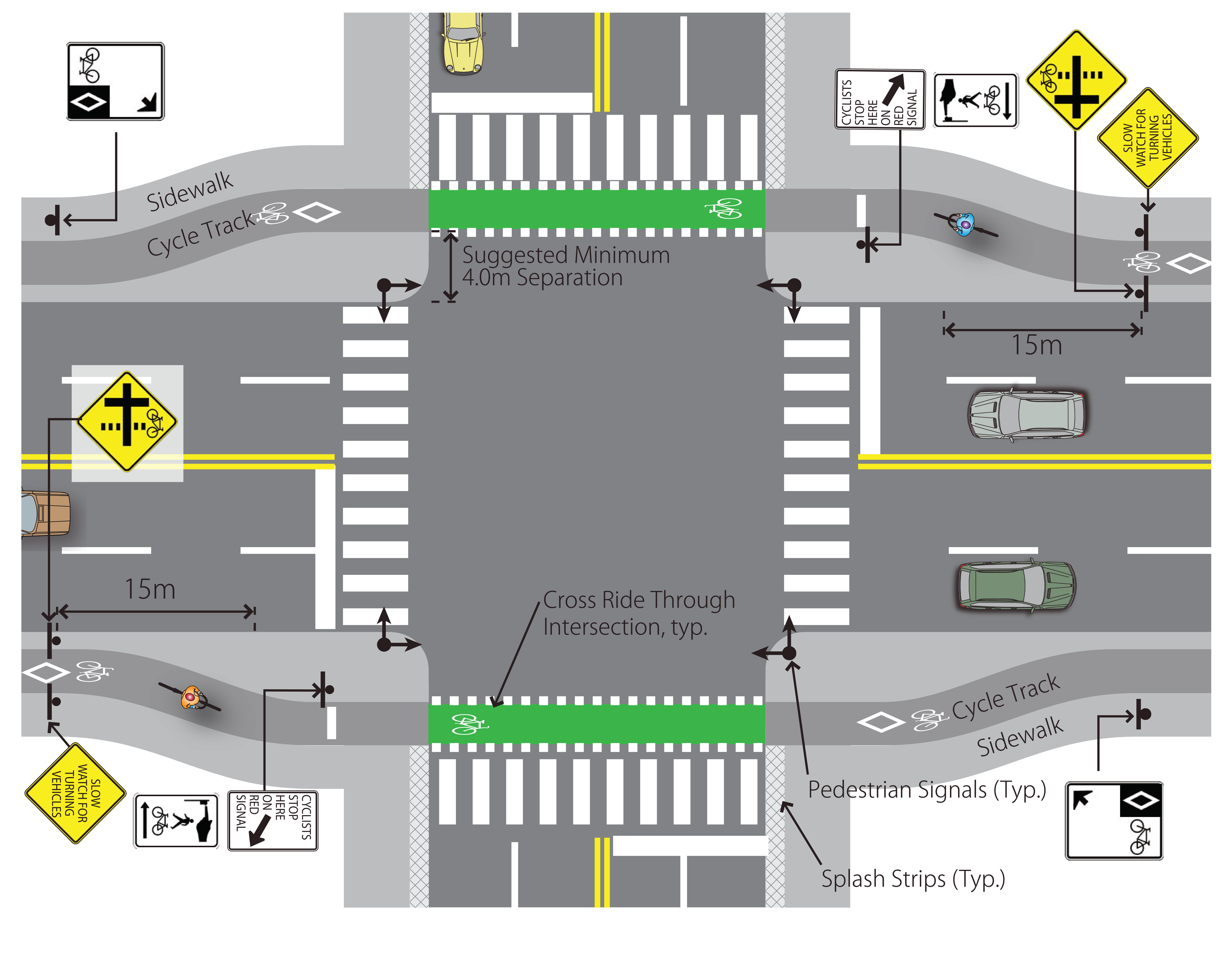
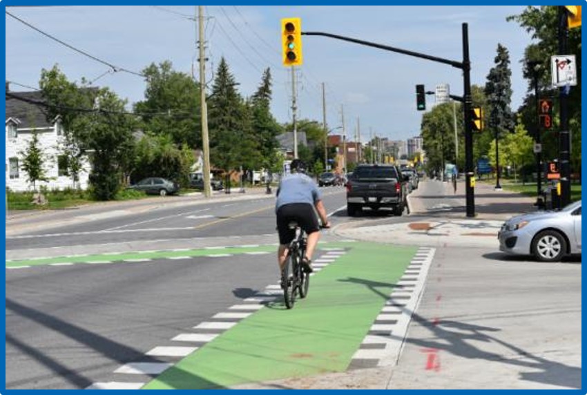
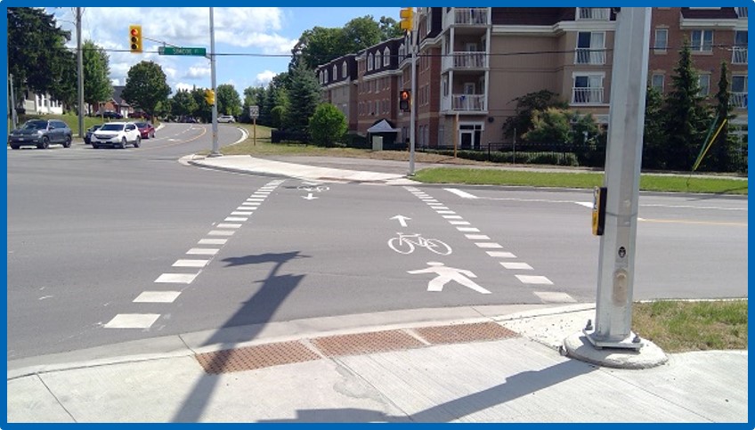
Preferred Preliminary Design Concept
3D Renderings
Below are three (3) 3D renderings based on the preferred preliminary design concepts at three different locations along Ninth Line.
Rendering A – South of Brinwood Gate (Looking North)
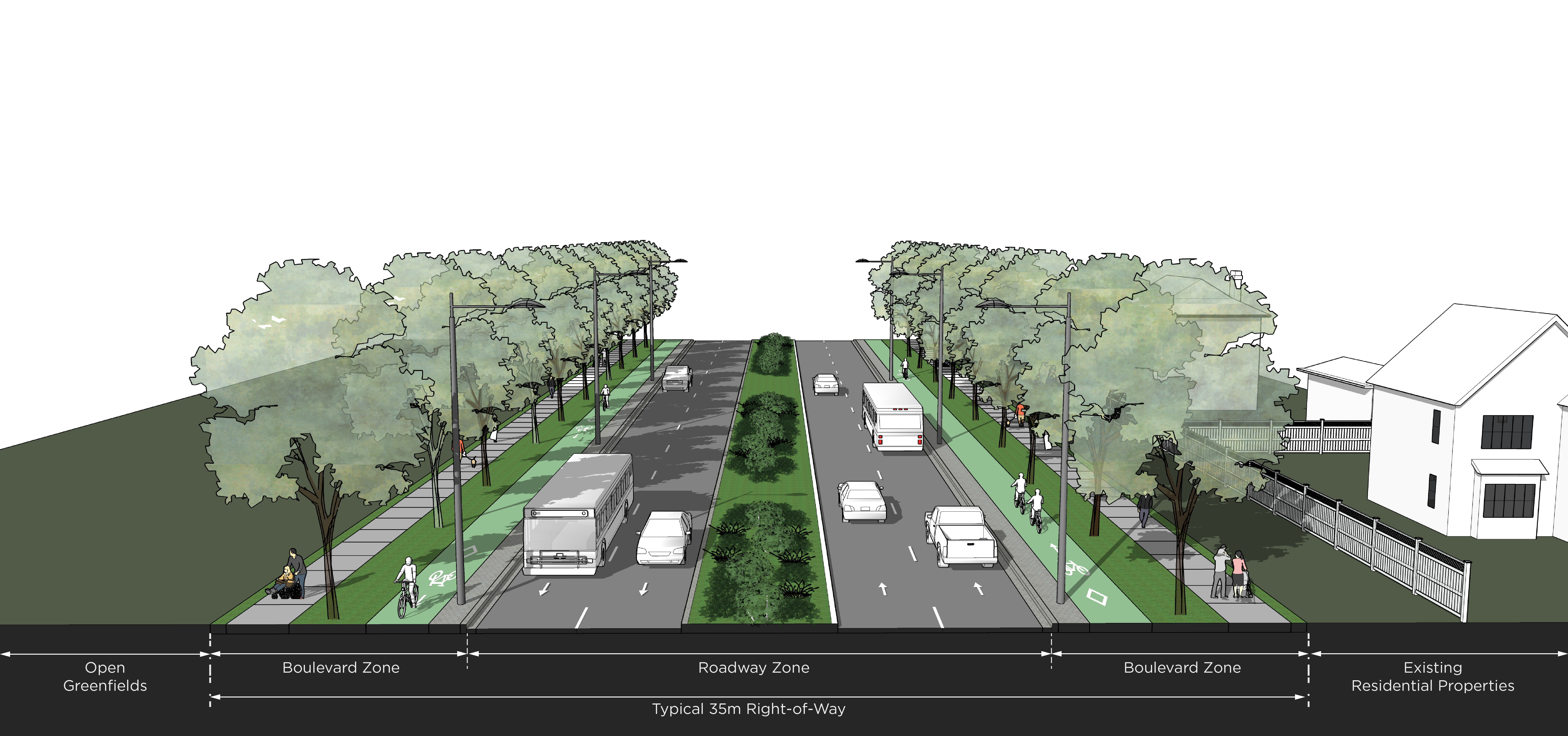
- Four lanes (two lanes in each direction)
- Raised centre median with low-lying shrubs and/or grass
- Separated boulevard cycle tracks and sidewalks on both sides
- Landscaping between cycle tracks and sidewalks on both sides
Rendering B – Between Manatee Way and Freeman Terrace (Looking North)
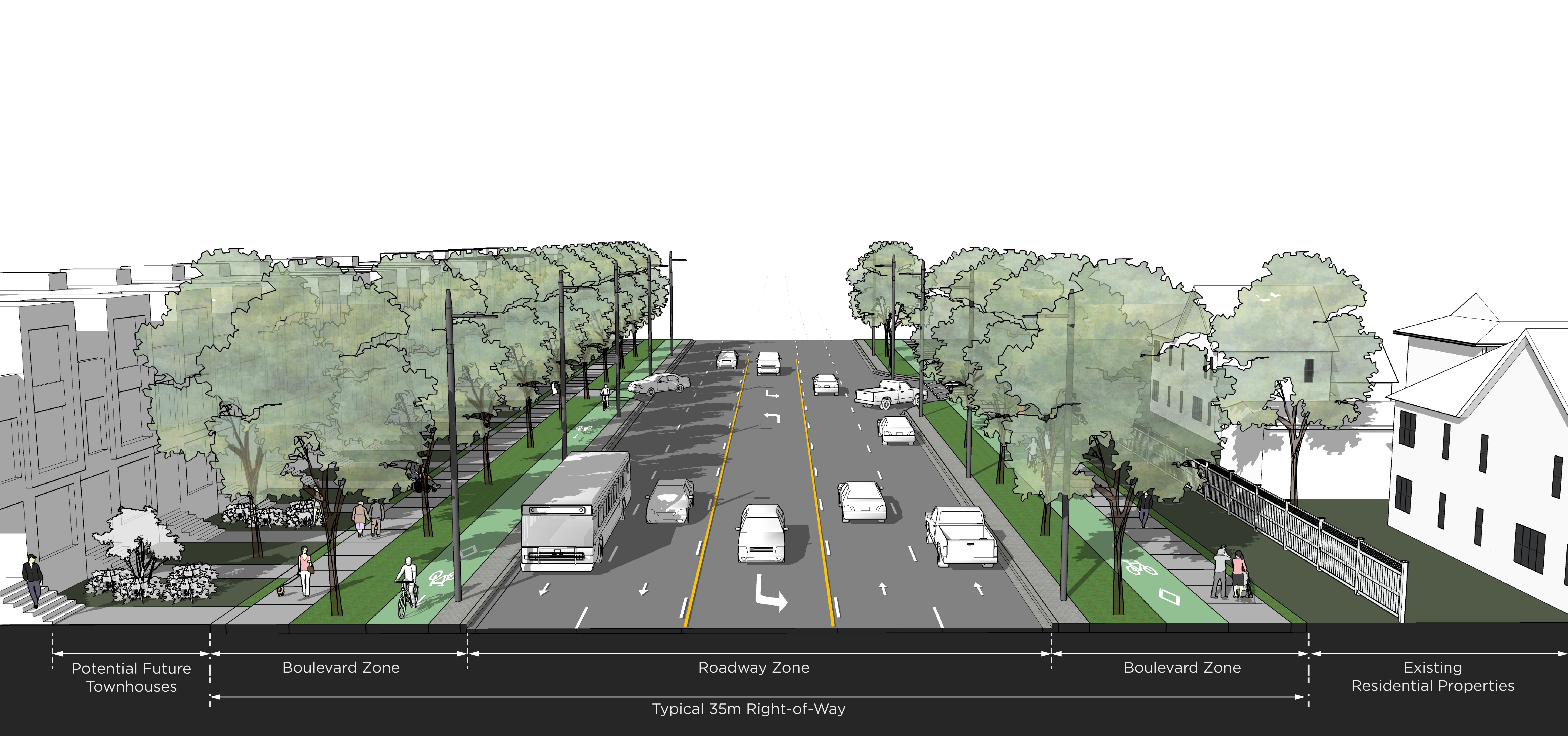
- Four lanes (two lanes in each direction)
- Centre left-turn lane to maintain access to side streets and driveways
- Separated boulevard cycle tracks and sidewalks on both sides
- Landscaping between vehicular lane and boulevard cycle tracks on the east side
- Landscaping between cycle tracks and sidewalks on the west side
Rendering C – North of Osprey Boulevard (Looking North)
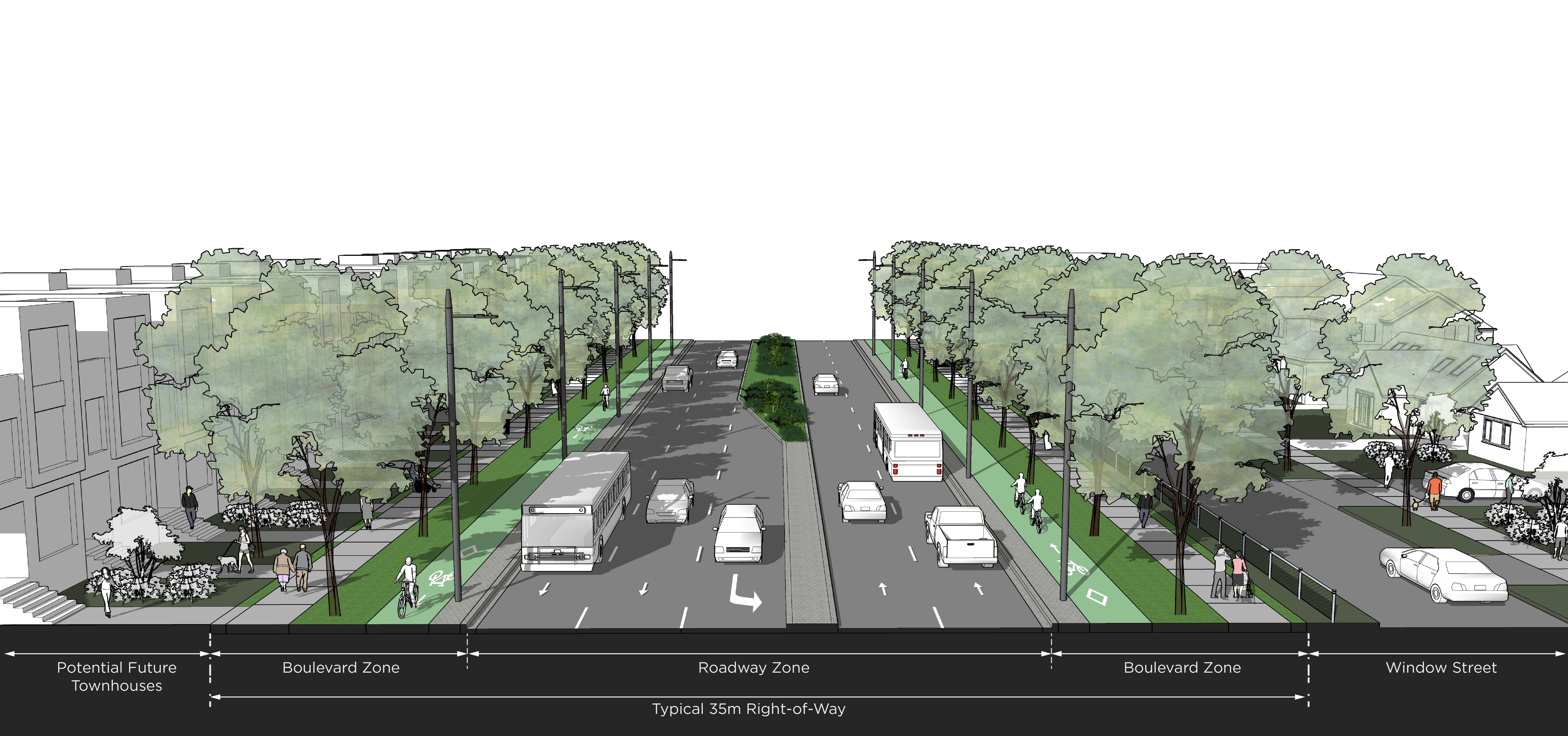
- Four lanes (two lanes in each direction) and a dedicated left-turn lane
- Raised concrete median beside the left-turn lane transitioning into a raised centre median with low-lying shrubs and/or grass
- Separated boulevard cycle tracks and sidewalks on both sides
- Landscaping between cycle tracks and sidewalks on both sides
Project Timeline and Next Steps
February 2020
June 2020
January 2021
Winter 2021
Spring 2021
February 2020
June 2020
January 2021
Winter 2021
Spring 2021
Next Steps
Review feedback from the public
Refine and Confirm Preferred Design Concept
Document Study Findings
File Environmental Study Report
Thank You for Participating in the Public Information Centre No. 2
Your input is very valuable to us!
Project Manager
City of Mississauga
Transportation & Works Department
201 City Centre Drive, Mississauga