Snohomish County CFS Virutal Open House
Welcome to the virtual open house for Community Floodplain Solutions!
Learn about the new Community Floodplain Solutions program and how it will help floodplain communities.
Get StartedTitle VI / ADA: Interpreter and translation services for non-English speakers and accommodations for persons with disabilities are available upon request. Call 425-388-6476. For questions regarding Public Works’ Title VI Program, contact our Title VI Coordinator via email at spw-titlevi@snoco.org, or phone 425-388-6660. Hearing/speech impaired call 711.
Si los solicita, hay disponibles servicios de interpretación y traducción para personas que no hablan inglés y adaptaciones para personas con discapacidades. 425-388-6476. Si tiene preguntas sobre el Programa de Obras Públicas del Título VI, comuníquese con nuestro Coordinador del Título VI por correo electrónico a spw-titlevi@snoco.org, o por teléfono al 425-388-6660. Las personas con dificultades auditivas/del habla deben llamar al 711.
Community Floodplain Solutions
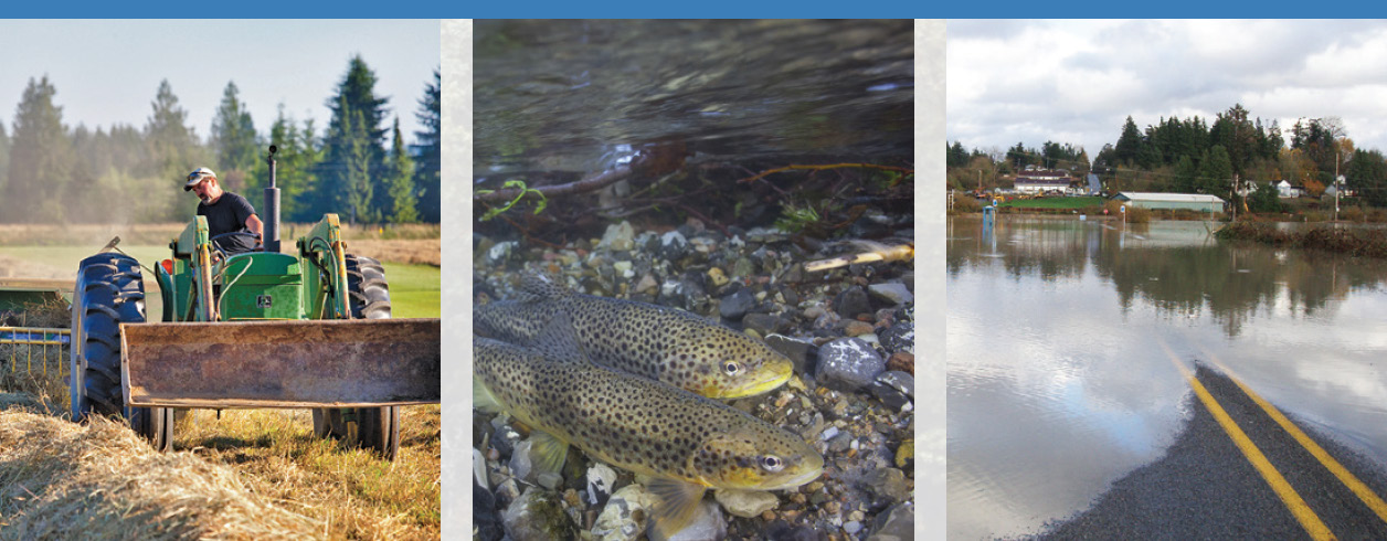
The floodplains of Snohomish County are facing difficult and complex challenges. Land conversion and changing weather patterns threaten the livelihoods of farmers. Salmon populations continue to decline due to habitat loss. Large flood events are becoming more frequent and damaging. We can’t solve these problems alone, or by relying on uncoordinated, infrastructure-heavy flood control measures of the past. A shift to integrated floodplain management is needed to help communities identify and advance solutions that achieve gains for FARM, FISH and FLOOD reduction.
Community Floodplain Solutions (CFS) is a collaborative effort between Snohomish County, the Sustainable Lands Strategy (SLS), the Conservation District and more than a dozen organizations – all working to improve how we manage floodplains. While some of the solutions we are highlighting in this open house are new, we recognize that many of the issues are not. In response to the variety of concerns and opportunities we’ve heard from the community over time, we have created a program to drive resources and funding toward multiple-benefit solutions. Working together, we can protect and enhance the quality of life in floodplain communities.
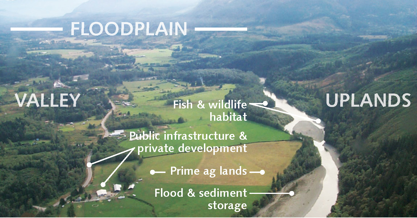
Floodplains provide important natural resources, such as prime agricultural land and fish habitat, as well as important benefits like flood and sediment storage. They are also places where many people live, work and recreate. Given the diversity of uses within our floodplains, we need to find mutually beneficial solutions to the problems confronting FARM, FISH and FLOOD management interests. Through integrated floodplain management, we can find these solutions together – solutions that give our rivers more room to roam while reducing flood hazards and improving agricultural viability. This work will help ensure that floodplain communities are places where future generations can enjoy the rural, agricultural, and natural values we cherish today.
Click to enlarge all images on the site.
WHAT IS INTEGRATED FLOODPLAIN MANAGEMENT?
Integrated floodplain management is a holistic way to manage river resources that benefit diverse interests. A healthy floodplain is a place where both people and nature thrive. In order to be successful, partners and willing landowners must work together to put forward ideas that protect the health and livelihood of a more resilient floodplain community.
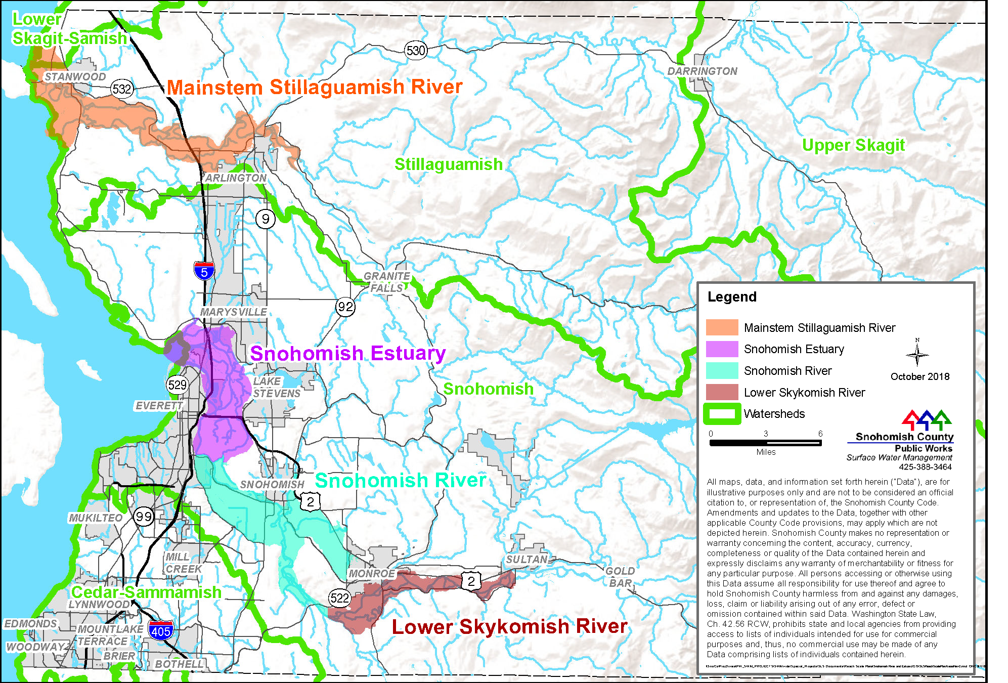
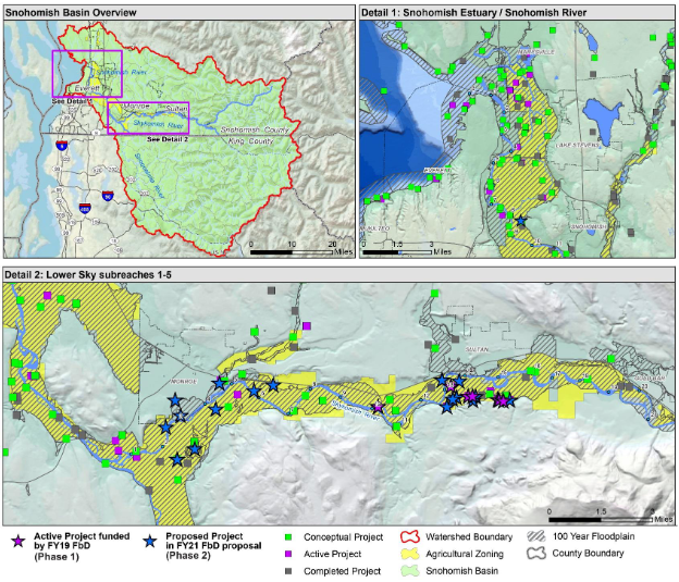
CFS partners will prioritize and address critical issues in four priority river reaches: Lower Skykomish River, Lower Stillaguamish River, Snohomish River and Estuary, and the North Fork Stillaguamish River. (See the map on the left from our reach-scale plan). Your support is needed to meet our goal of protecting FARM, FISH and FLOOD uses within these reaches for the benefit of all.
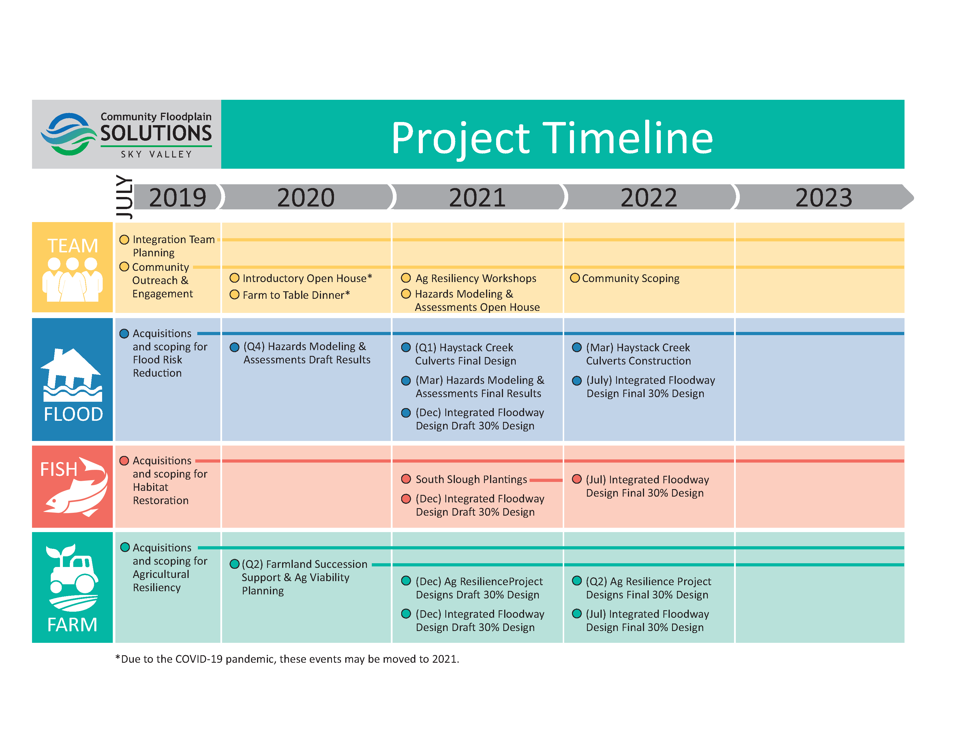
As noted in our project timeline, many of our outreach efforts have been delayed due to the COVID-19 pandemic and social distancing requirements. This open house is our first effort to introduce a program that builds upon decades of planning and community input. We will follow up with a Tele-Town Hall event in the early spring to (1) address the feedback, questions and concerns we received during the open house, and (2) provide a status update to the community and an additional opportunity to share feedback with us.
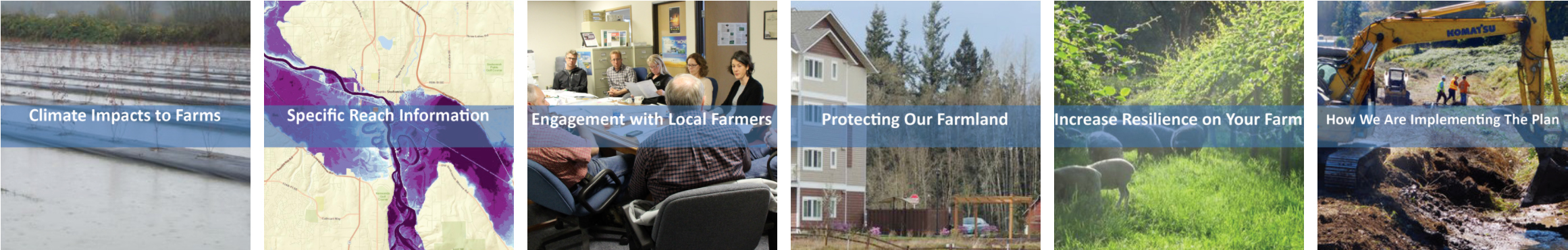
About the Community Floodplain Solutions Program
Community Floodplain Solutions will use a variety of tools to improve floodplains for future FARM, FISH and FLOOD uses. Click on each tool below to learn more about how CFS could help communities in the Lower Skykomish region, also called Sky Valley.
Flood Risk Reduction
CFS supports integrated, multiple-benefit projects that allow the river and its tributaries to migrate naturally while reducing flood risks and conserving land for agriculture, fish habitat and other beneficial uses. The design below from King County gives one example of what an integrated project might look like.
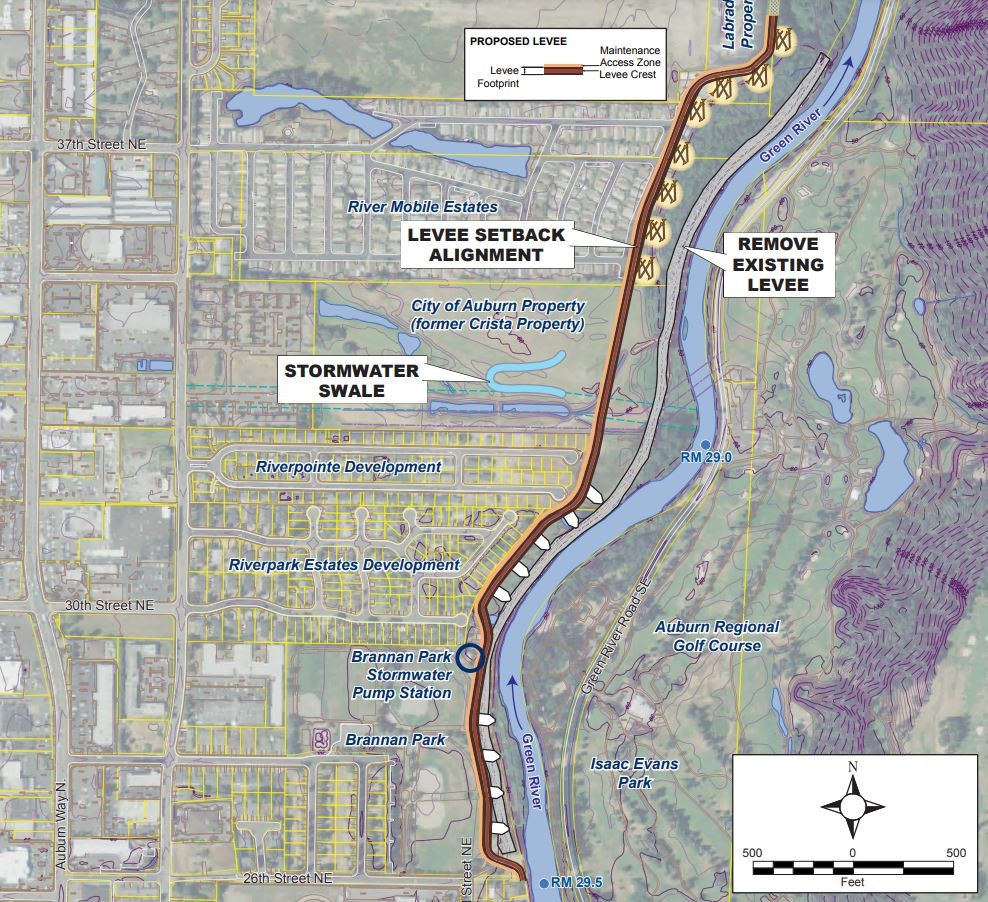
EXAMPLE of a levee setback project in King County. Project benefits include reduced flood risk to the City of Auburn and the Green River Valley as well as improved natural river functions that enhance habitat. Note recreational uses on both sides of the river. Photo Credit: King County Water and Land Resources Division
EXPECTED OUTCOMES
- Flood hazard maps will give floodplain communities a better understanding of current and future flood risks.
- Flood hazard mapping studies will help us identify and prioritize integrated projects.
- Integrated actions will reduce and/or mitigate flood risks to residents, businesses and infrastructure by giving the river more room to move and providing locations for floodwater and sediment storage.
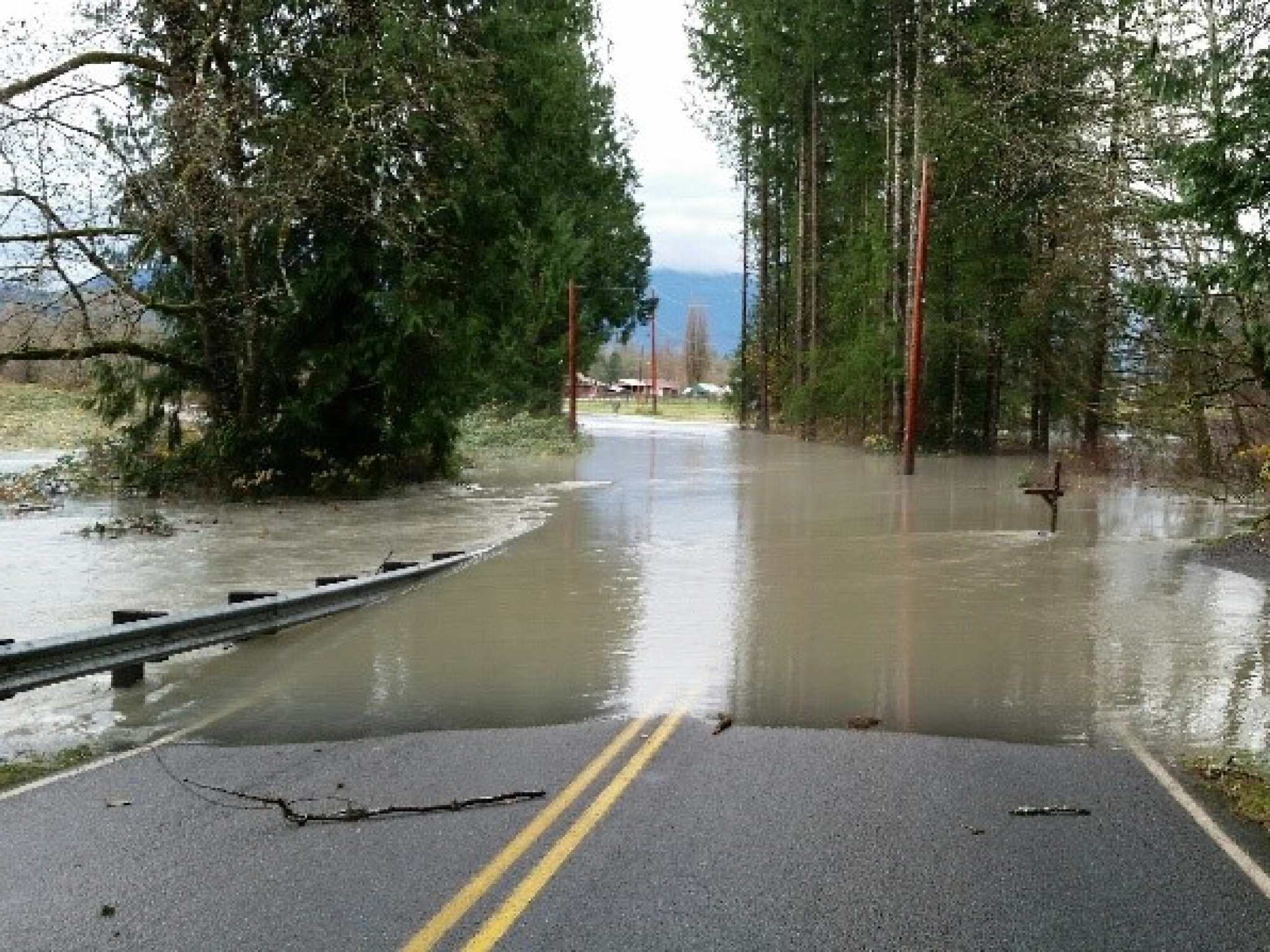
Flooding hotspot at Mann Rd (Devil’s Elbow)
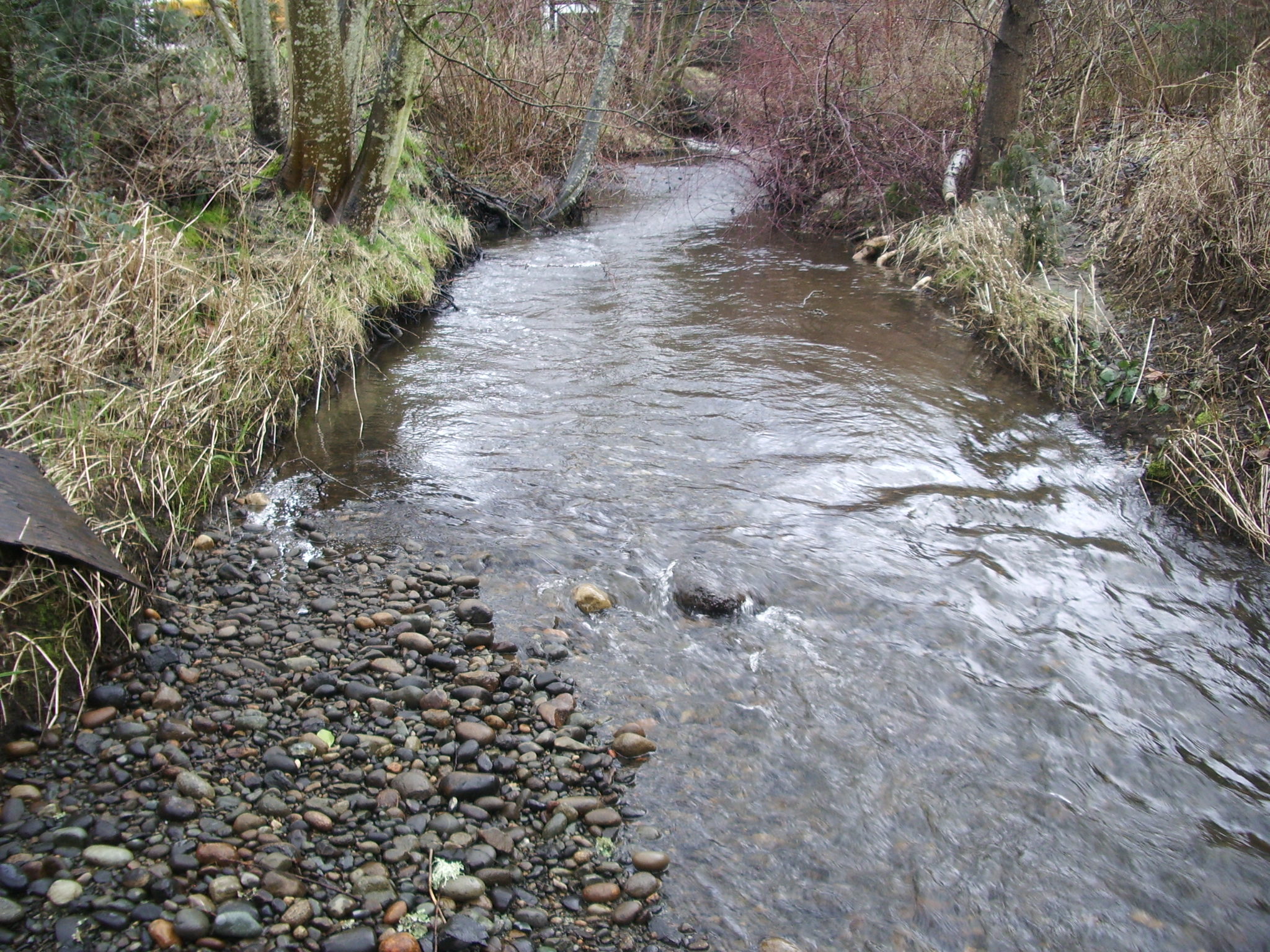
Significant deposition and channel widening at upstream end of South Slough, looking downstream
Flood Hazard Studies
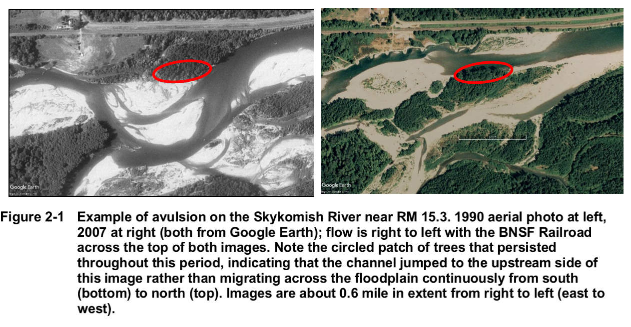
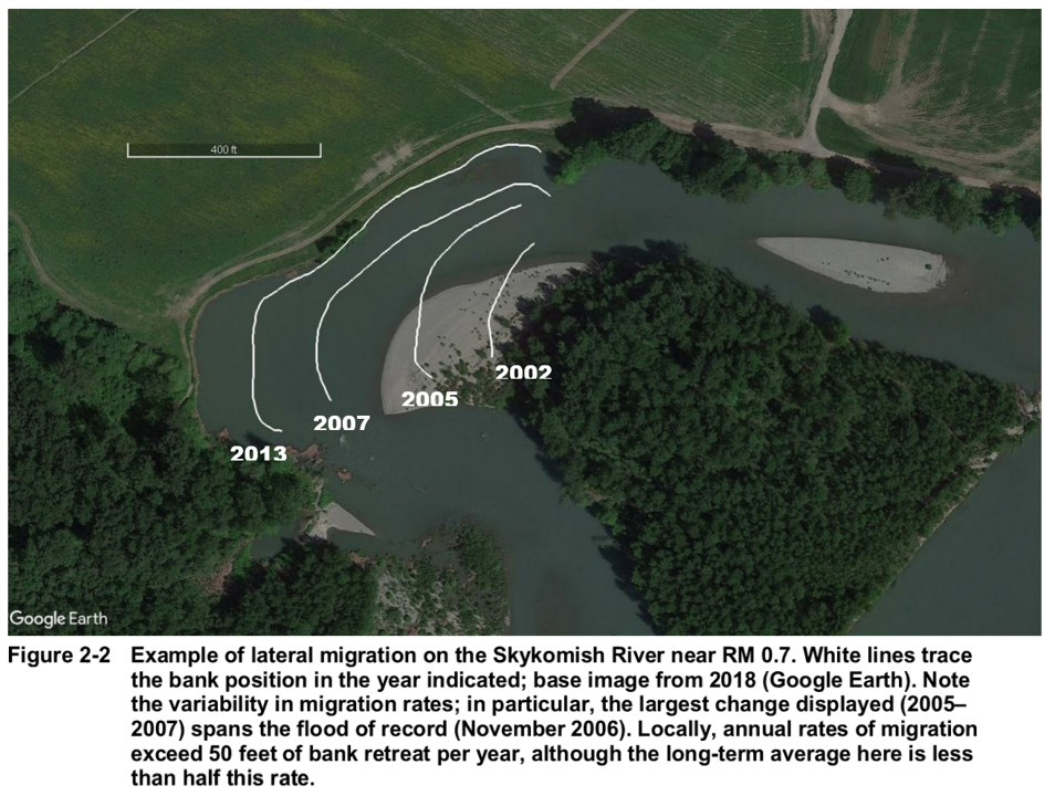
An important goal of the Community Floodplain Solutions (CFS) program is understanding and predicting future risks associated with changing river conditions. Over time, the Skykomish River moves across its floodplain. This channel migration can occur gradually as the river erodes one bank and deposits sediment along the other. It can also occur abruptly, when a channel shifts into a new or previously occupied location.
The purpose of flood hazard mapping studies funded through CFS is to model, assess and map river conditions to inform future projects. Flood hazard mapping typically looks at water depth – how much water is in the river channel or on the floodplain. These studies also look at the river's changing shape and location, not just water depth, across a broader reach scale.
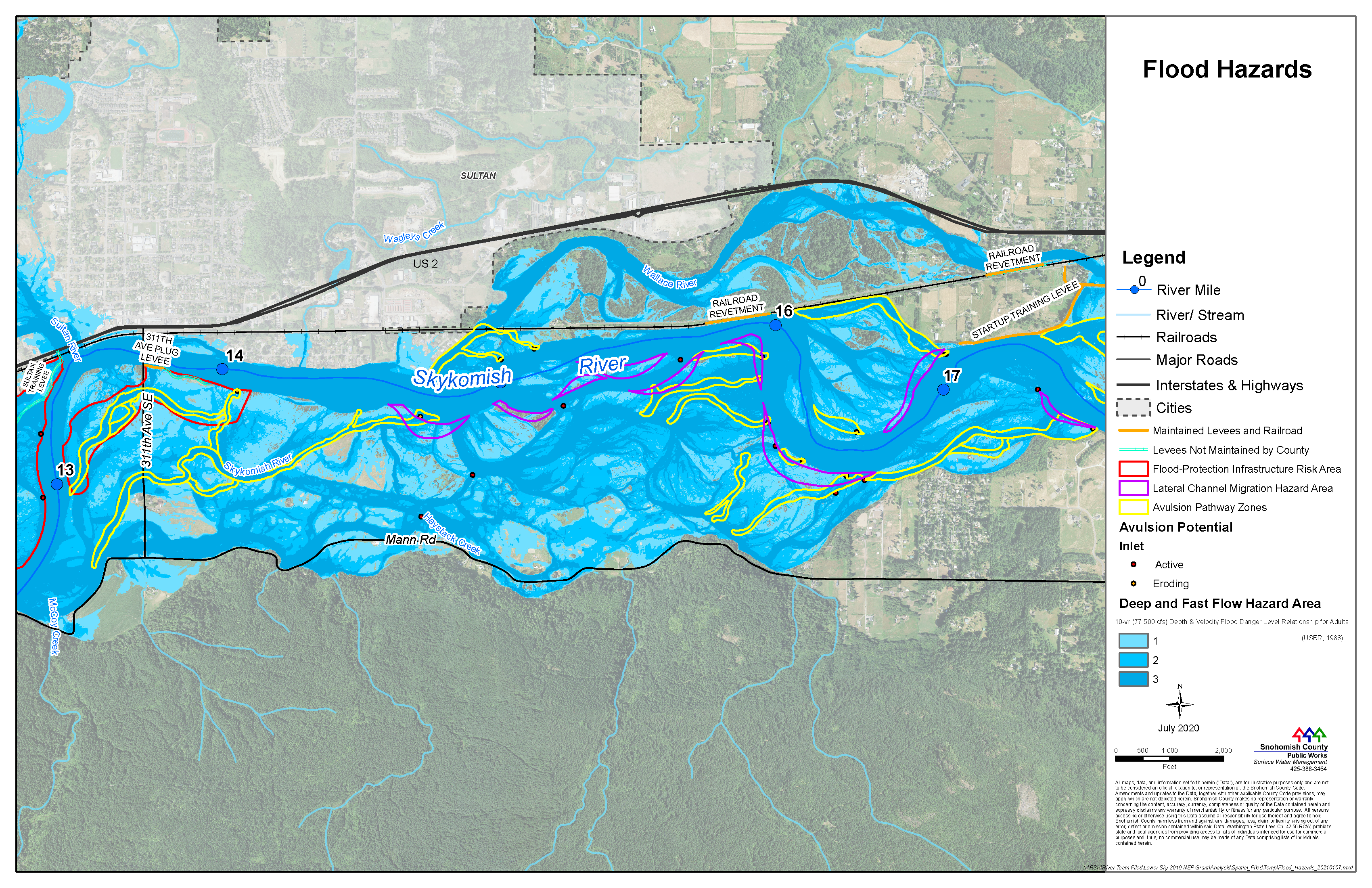
River hazard maps, like the one shown, will help educate residents about potential risk and better identify and prioritize future projects. Funding for flood hazard studies is provided by CFS partners and the Environmental Protection Agency (EPA).1
The CFS team aims to understand and predict future flood risks by asking these questions:
- What major factors shape how the river is moving today?
- What will the river look like in the next 50 years?
- How much rainfall will we receive? How much water will be coming down the river?
- How will the river move within the floodplain? How deep and how fast will the water flow?
- How will the land change in the process?
The figures below, from the Skykomish River geomorphic assessment, show lateral migration of the Skykomish River and how land changes over time.
The information in the Channel Migration Zone study for the Skykomish River led to an emergency repair of the Haskel Slough levee, which was completed in November 2020.
Visit our Flood Hazard Mapping webpage to learn more about the geomorphic assessment and related studies.
Using the best available science and data, we can forecast what the river is most likely to do and locations of potential flood damage. The completion of flood hazard studies is the first step in identifying projects that address flood risk, such as the Mann Road project, and developing criteria for prioritizing future projects. While current studies focus on the Skykomish River system, they can be used to inform actions elsewhere in the basin.
The interactive flood map below uses data from flood hazard studies and shows areas of the Sultan Reach under high and low levels of flooding.
Click the house icon ![]() and move the slider bar
to see where the floodwaters would be during lower-level (left side) or higher-level
(right side) flood events.2
and move the slider bar
to see where the floodwaters would be during lower-level (left side) or higher-level
(right side) flood events.2
With a better understanding of potential risks associated with rainfall and river movements, CFS partners can assess potential projects and evaluate how they will affect the landscape. The goal is to provide integrated and sustainable actions that provide resilient outcomes for residents, farmers and fish interests.
If you are concerned about flooding issues along the Skykomish River, please contact CFS.info@snoco.org.
1This project has been funded wholly or in part by the United States Environmental Protection Agency under assistance agreement PC-01J22301 through the Washington Department of Fish and Wildlife. The contents of this document do not necessarily reflect the views and policies of the Environmental Protection Agency or the Washington Department of Fish and Wildlife, nor does mention of trade names or commercial products constitute endorsement or recommendation for use.
2"Lower-level" is a flood event at a two-year recurrence interval, and "higher-level" is a flood event at a ten-year recurrence interval.
Incentive Programs
We can provide eligible and willing property owners financial compensation for all or a portion of their property to be repurposed for agricultural use or habitat restoration.
Beginning in the summer of 2021, we will identify properties that are eligible for this acquisition process. We are doing this work in partnership with the Tulalip Tribes and Washington Farmland Trust to provide options for FARM, FISH and FLOOD uses on acquired land, and we will prioritize properties where there can be multiple benefits.
Floodplains by Design Acquisition Strategy
Washington Farmland Trust (formerly PCC Farmland Trust) has worked with local farmers to develop criteria to prioritize lands for protection through agricultural easements. (See Figure 1)
The county is currently developing an acquisition strategy, integrating the following information, to help guide multiple-benefit property acquisitions:
- WA farmland trust farmland conservation prioritization to guide the purchase of land for long-term agricultural conservation;
- Tulalip Tribes conservation priorities for the purchase of property for salmon recovery; and
- Flood risk reduction priorities identified by the recent flood hazard studies conducted by Snohomish County.
As part of this undertaking, we are developing a spatial tool that will allow us to overlay flood, fish and farm priorities to see where there is overlap to guide use of funds. Information will be available by summer 2021.
Spotlight:
Located within an area of Snohomish County that is highly vulnerable to development, the Reiners sold their family farm to the PCC Farmland Trust (now the Washington Farmland Trust). The Trust then preserved the land using a conservation easement so that it can only be used for agriculture in the future. The conservation easement also means that the land will remain more affordable than it would otherwise be at traditional market rates. (See Figure 2)
“As Snohomish County’s population grows, land is becoming too expensive for the average farmer. Many are getting ready to retire, without anyone to take their place, so it’s important now to preserve farms.” – Melissa Campbell, Executive Director, Washington Farmland Trust
Source: 100-year family farm sold to preservation trust | HeraldNet.com
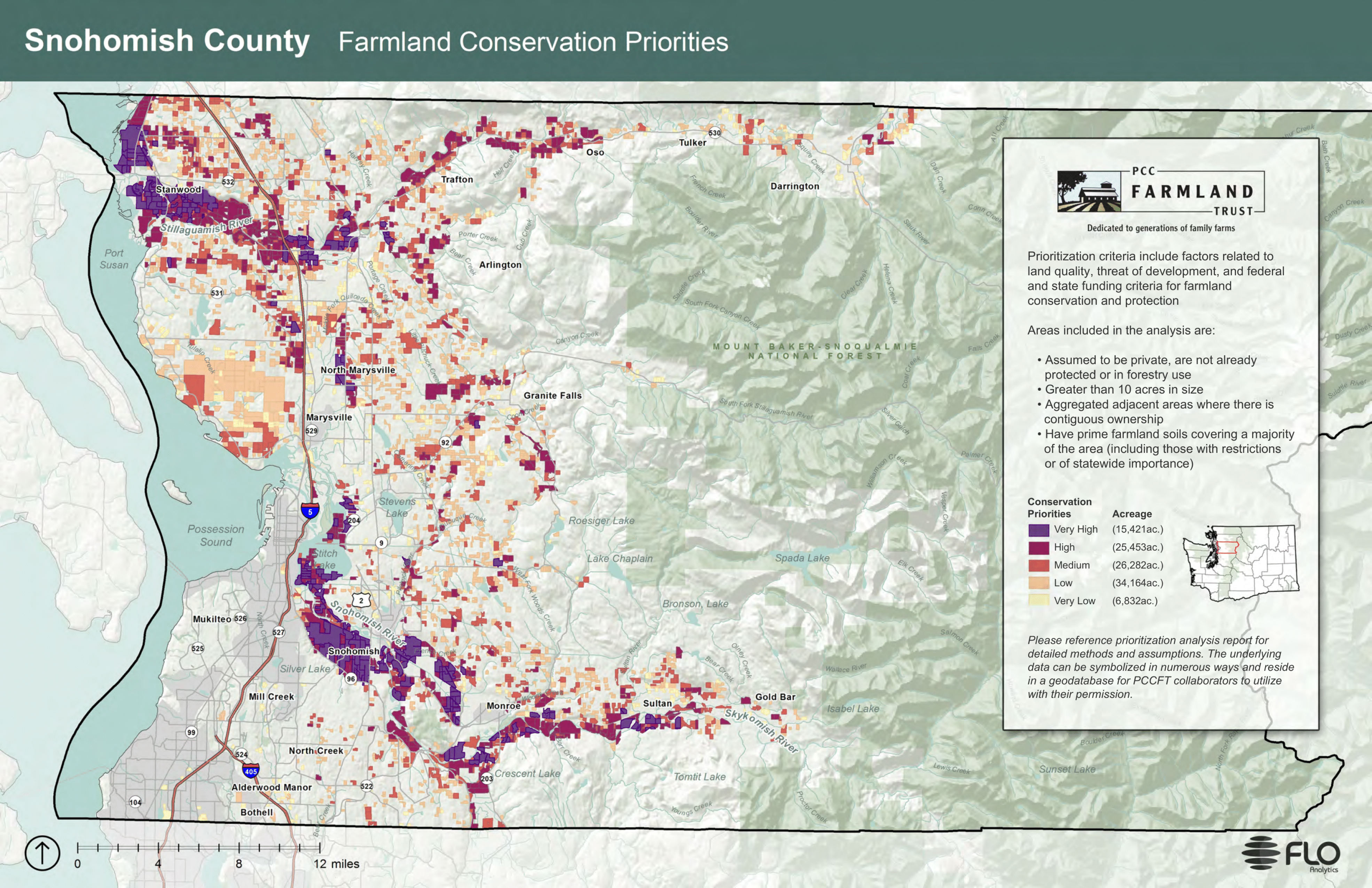
(Figure 1) Farmland Conservation Priorities
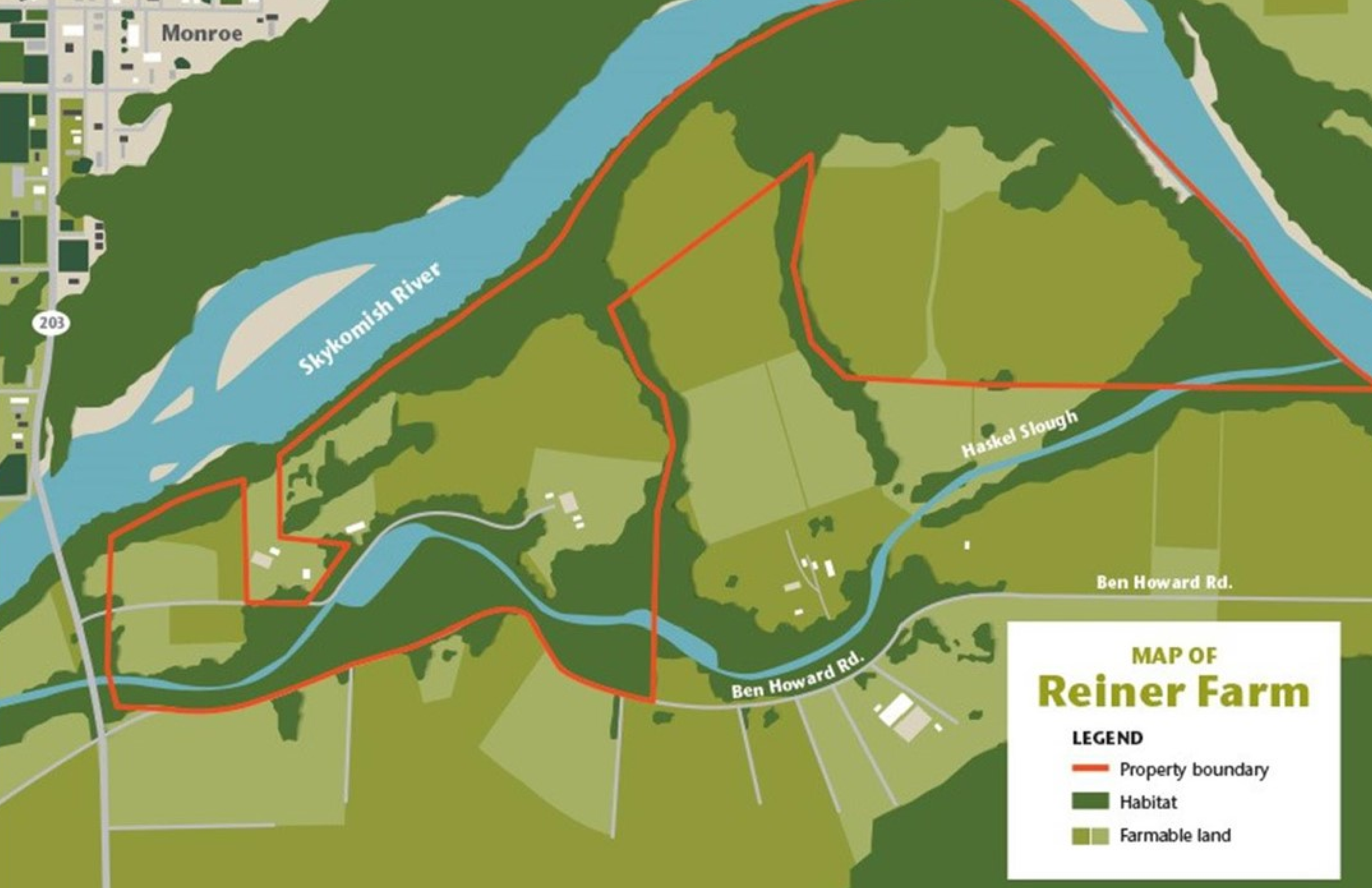
(Figure 2) Reiner Farm maps
Process for Acquisitions and Easements
CFS partners are working with willing landowners to develop a multiple-benefit easement and acquisition strategy along the Skykomish River that will target properties with the highest risk of repetitive flood loss and the greatest potential for farmland preservation and salmon recovery. The process requires that we consult with partners, review new and historic river modeling data and seek public input.
All these steps are necessary to determine the areas best suited for future work. The county follows federal and state guidelines to acquire eligible flood damaged properties. Property owners will not be forced to sell property and willing participants who qualify will receive fair market value as established by an authorized appraiser. We recognize the process can be long and frustrating. Please know that we are committed to working together to find fundable solutions that provide the greatest benefits for all.
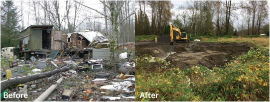
Skyview tracts neighborhood consisted of over 100 residential and recreational lots subject to repetitive flooding, with reported flood depths of up to ten feet. The few houses that existed in this neighborhood were built before the county adopted the National Flood Insurance Program, which now prohibits building permanent structures in river floodways.
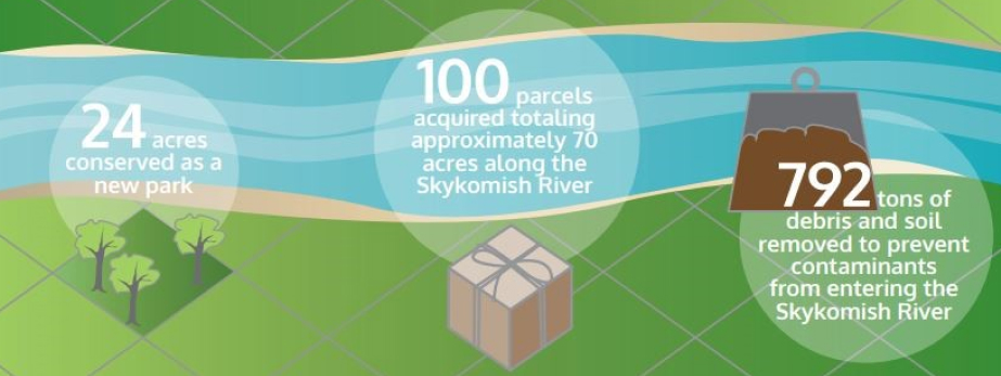
Over the past two decades, Snohomish County used a variety of funding sources to purchase Skyview tracts property from willing landowners. The most recent cleanup effort was completed in 2016, removing 792 tons of debris and contaminated soil for proper disposal. County efforts at this site protect citizens from future flood damage, the river from waste contamination and conserve public open space that provides recreation and restoration opportunities.
Other Incentive Programs
Farmland Conservation Assistance
The Washington Farmland Trust's mission is to protect agricultural land for farming. To accomplish this, WFT works with landowners to purchase their farm’s development rights. WFT uses tools like agricultural conservation easements (process described above) which are designed to limit future development and non-farm uses without restricting agricultural operations. To help ensure the land remains affordable to future generations of farmers, WFT can include additional restrictions designed to increase the easement’s value to the existing landowner and lower the land’s future purchase price for a farm buyer.
In some circumstances, WFT also purchases at-risk farmland with the goal of returning it to private ownership by selling to a local farmer. This approach is called “buy, protect, sell”. The Trust works with willing farmers to buy the property, remove the development rights and place the property in long-term agricultural conservation. When the Trust is ready to resell the farmable area, they will accept applications to purchase or lease the property. If there is an existing tenant on the property, the Trust will give that tenant the first opportunity to purchase the property.
FEMA Financial Assistance
To reduce future disaster claims, the Federal Emergency Management Agency (FEMA) maintains programs that provide funding to state and local governments for eligible mitigation (corrective) activities. Qualified activities include home elevations, home relocations and the acquisition and removal of structures in high-risk areas. To learn more, visit our Technical Assistance webpage.
Streamside Landowner Technical Assistance
Snohomish County provides a variety of resources to streamside landowners in unincorporated areas including technical assistance, restoration guidance, educational workshops, print materials and site visits customized to the needs of your property. All resources are designed to help improve water quality and aquatic habitat, and to reduce downstream impacts such as flooding, erosion and pollution.
The CFS team can connect you with the people and resources to help.
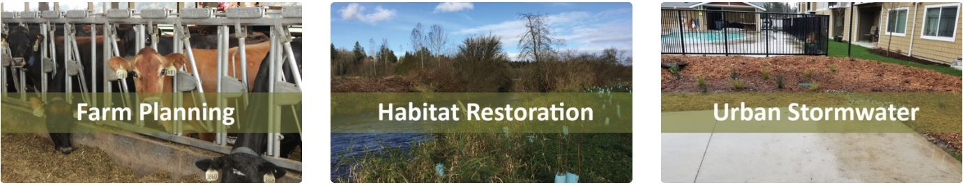

Snohomish Conservation District has many services to help landowners protect and enhance natural resources. Many incentive programs are included in the following categories: farm planning, habitat restoration, urban stormwater, sound education, sound horsekeeping and lawns to lettuce.
Agricultural Resiliency
Protecting our viable agricultural land from conversion so farmers can provide for our community’s needs into the future is a critical component of the Agriculture Resilience Plan.
EXPECTED OUTCOMES
- Multiple-benefit projects will aim to increase community resilience to floods, create habitat and protect farmland.
- Support for BMPs will protect soils and fertility, reduce water needs and improve farmers’ ecological relationship with the landscape.
- We will work with SCD to implement the 2019 conservation plan and actions included in the plan.
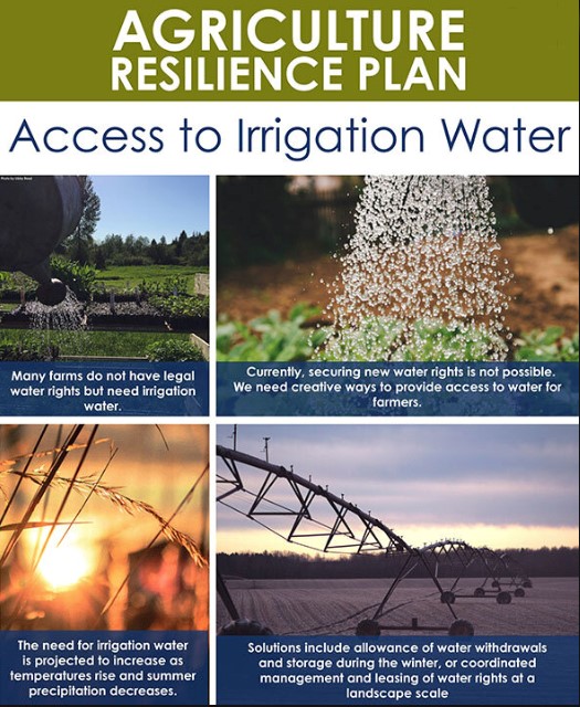
SCD is leading the design and development of capital projects in the Snohomish and Skykomish River basins that will increase agricultural resilience. Additionally, SCD is supporting programs to assist farmers in applying resilience Best Management Practices (BMPs). Changes in flooding and groundwater levels could result in needed infrastructure improvements for drainage and protection from flood waters and rising sea levels. In addition, changes in snow accumulation and the timing of precipitation and runoff could necessitate drought resilience improvements.
- Drainage improvements could include improved pumping options, upland water storage, protection from flood waters, dike improvements and ditch cleaning
- Drought resilience improvements could include water rights acquisition/banking, water storage, irrigation efficiencies and groundwater infiltration and recharge projects
- Funding will be solicited for project design and construction
Snohomish County implements various agricultural initiatives that seek to conserve approximately 63,000 acres of agricultural land for long-term farming. Learn more about the county’s Agricultural Initiative.
CFS partners work with local land trusts, the SCD, the Snohomish County Agriculture Coordinator and local farmers to determine needs and opportunities to conserve agricultural land.
Salmon Recovery
This work promotes the FISH in our mission to protect FARM, FISH and FLOOD uses.
Dikes, bank armoring, roads, railroads and bridges have confined rivers, disconnecting them from their floodplain and side channels. Side channels and floodplains are important habitat for salmon.
With assistance from our partners, we are restoring natural river processes by designating areas where the river can reconnect to its historic floodplain, allowing the river room to create and maintain natural habitat through anticipated channel movement and side channel formation. We are restoring natural river function by removing invasive species and promoting natural vegetation growth. We do this by using tools like acquiring land, removing impediments to natural river movement and restoring side channels and native vegetation that will provide salmon habitat.
This work has also never been more important – salmon populations are at historically low levels across most species, so we need to do what we can to recover their populations by providing adequate habitat.
We are working with partners on salmon recovery efforts by restoring natural river and floodplain processes and functions.
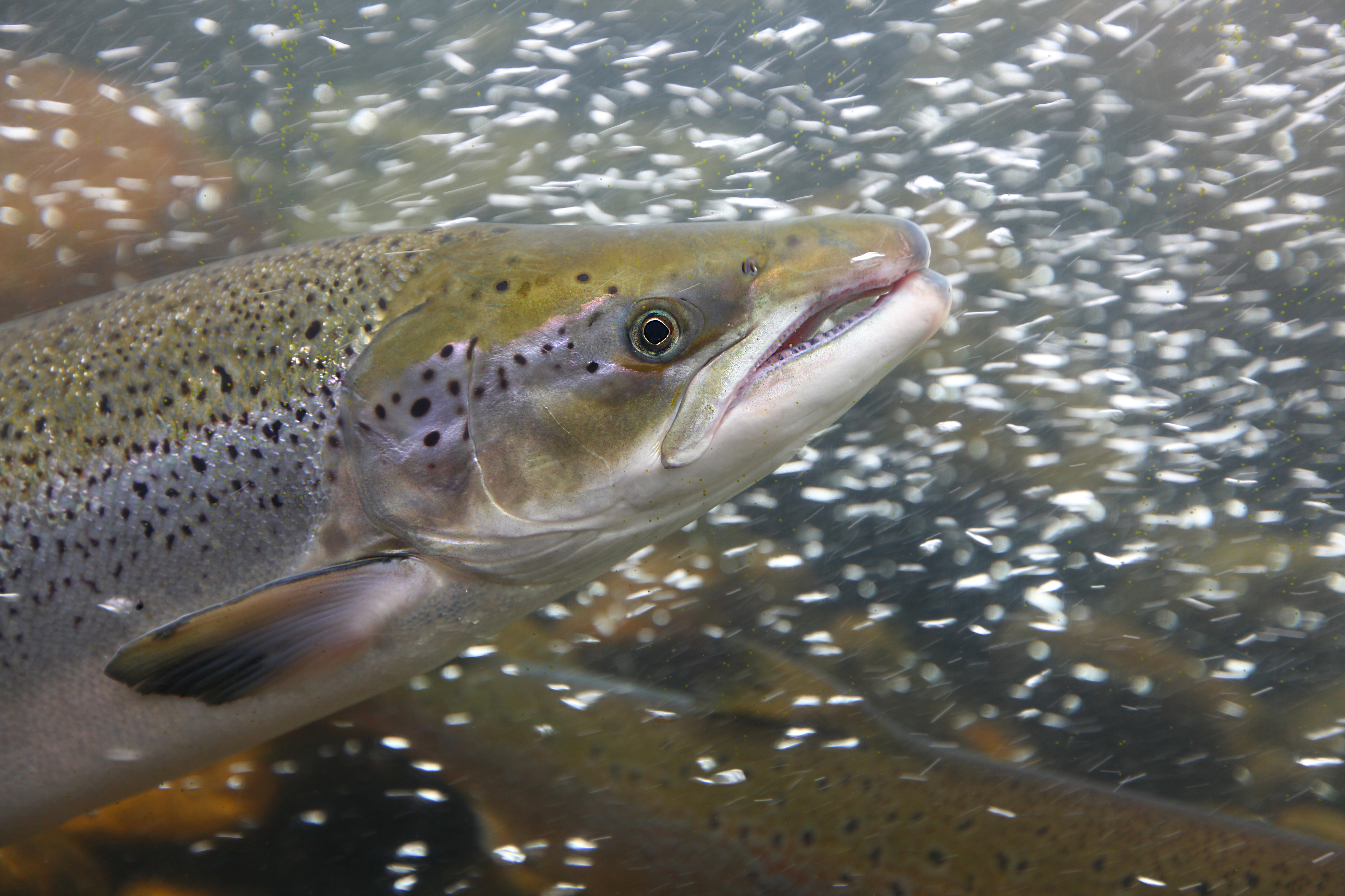
Chinook are the main food source for the Southern Resident Orca.

If the Chinook population continues to decline, the Southern Resident Orca population will follow.
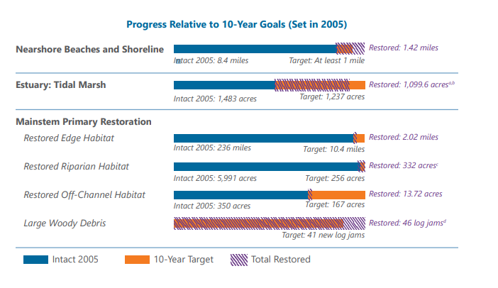
Chinook salmon were federally listed as threatened under the Endangered Species Act (ESA) in 1999. In 2005, salmon recovery partners approved a salmon recovery plan and identified habitat restoration targets to track their progress on restoring salmon habitat to support the recovery of salmon populations. Salmon habitat restoration along the Skykomish River falls into the “Mainstem Primary Restoration” category noted in the graphic above. This graphic shows that since the adoption of the 2005 salmon recovery plan, progress is being made on our habitat restoration target, but much more work is needed, particularly with restored edge habitat (bank armoring removal) and with restored off-channel habitat (floodplain habitat). Source: Snohomish River Basin Salmon Conservation Plan Status and Trends (Dec. 2019)
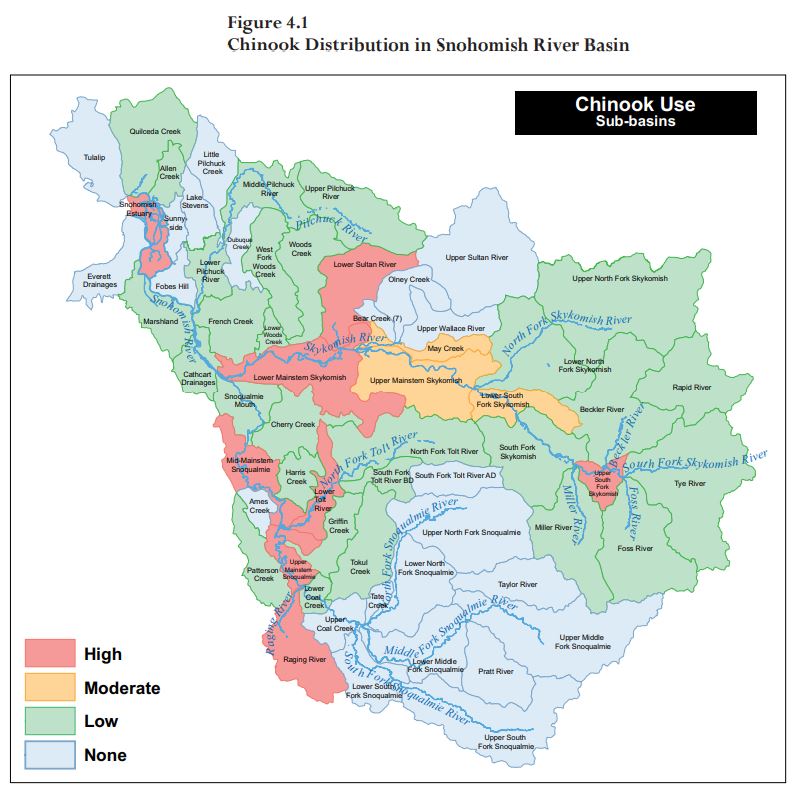
Within the Snohomish River Basin, the highest concentration of Chinook use is in the Skykomish and Snoqualmie mainstems. Our efforts focus on restoring habitat for salmon; habitat where salmon can rest, hide from predators, forage for food and seek refuge from fast river currents as they make their way downstream to the salt water. Source: Snohomish River Basin Salmon Conservation Plan (June 2005)
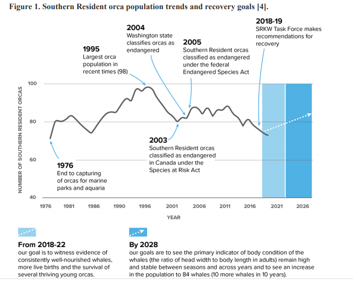
Recovery of the Southern Resident Orca population largely depends on our ability to restore and protect habitat for Chinook salmon, the orcas’s primary food source. Source: Southern Resident Orca Task Force – Final Report and Recommendations (Nov. 2019)
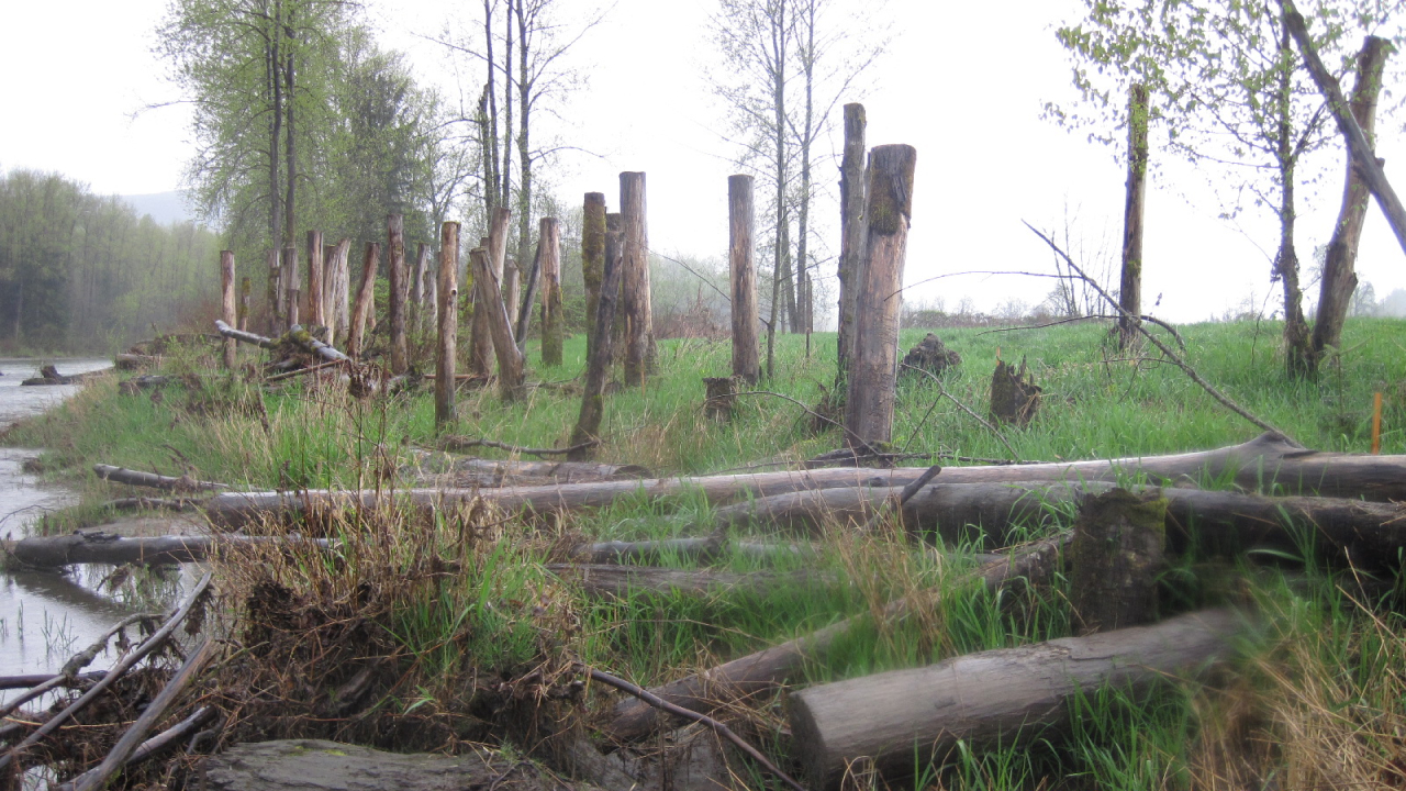
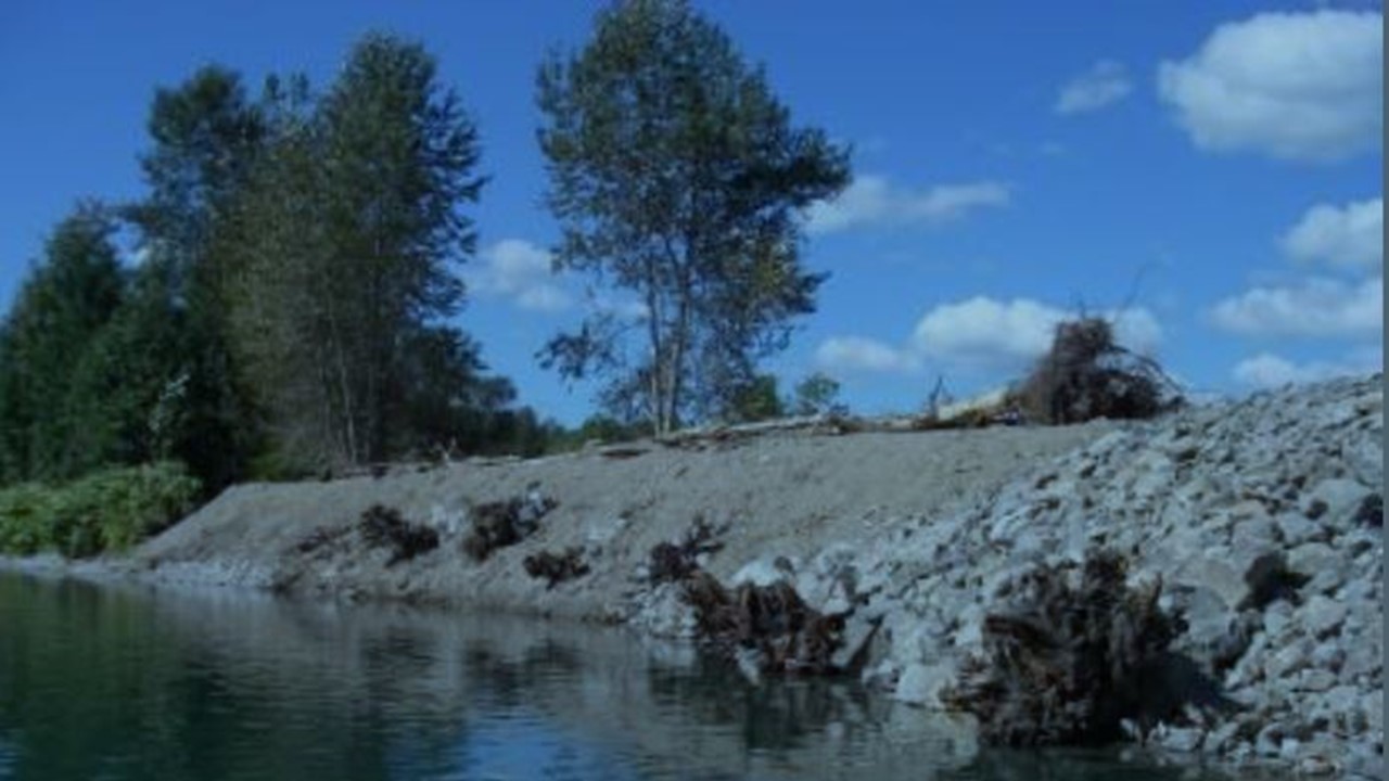
The photos below show a reconnected side channel that had been cut off from Snohomish River flows and fish access since the early 1930’s. As you can see, the channel is now open to fish during normal river flows, thus providing critical rearing habitat for ESA-listed Chinook salmon. Photo credit: Snohomish Conservation District
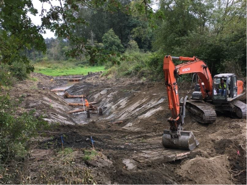
During Construction
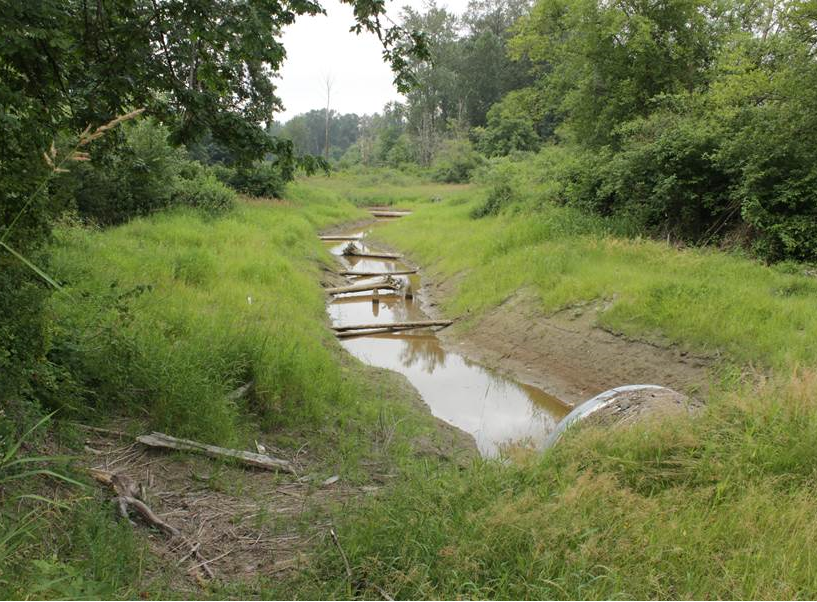
After Construction
Projects
Community Floodplain Solutions currently has two phases. We began implementing Phase I in 2019 and are piloting integrated actions in the Sultan Reach (Lower Skykomish River miles 9 to 16). We are seeking funding for Phase II of CFS which would look at actions further downstream, toward the Snohomish River confluence with the Skykomish River. These phases are described below, along with next steps for project development.
Phase I
We have identified upcoming projects and infrastructure modifications to support our efforts to protect FARM, FISH and FLOOD uses.
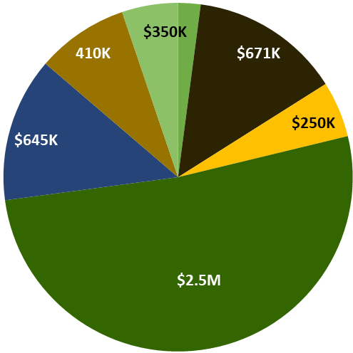
Phase I consists of a $4.8 million award, leveraging $1.93 million of local funding. The goals of the projects in this phase are to:
Reduce flood-related risk to people and public infrastructure;
Correct three fish passage barriers, improving access to 2.6 miles of forested stream habitat for salmonids;
Restore up to 30 acres of riparian area;
Protect up to 200 acres of floodplain land for future restoration of natural river processes and long-term agricultural uses;
Model, assess and map river conditions to provide technical basis for future multiple-benefit projects;
Complete design for an integrated floodway project and three agriculture-resiliency projects;
Educate residents about living in a dynamic floodplain, channel migration risks and consideration of how river processes may shift in the future.
EXAMPLE ACTIONS: CFS partners aim to improve the movement of flood flows by replacing failed culverts and raising sections of roadway.
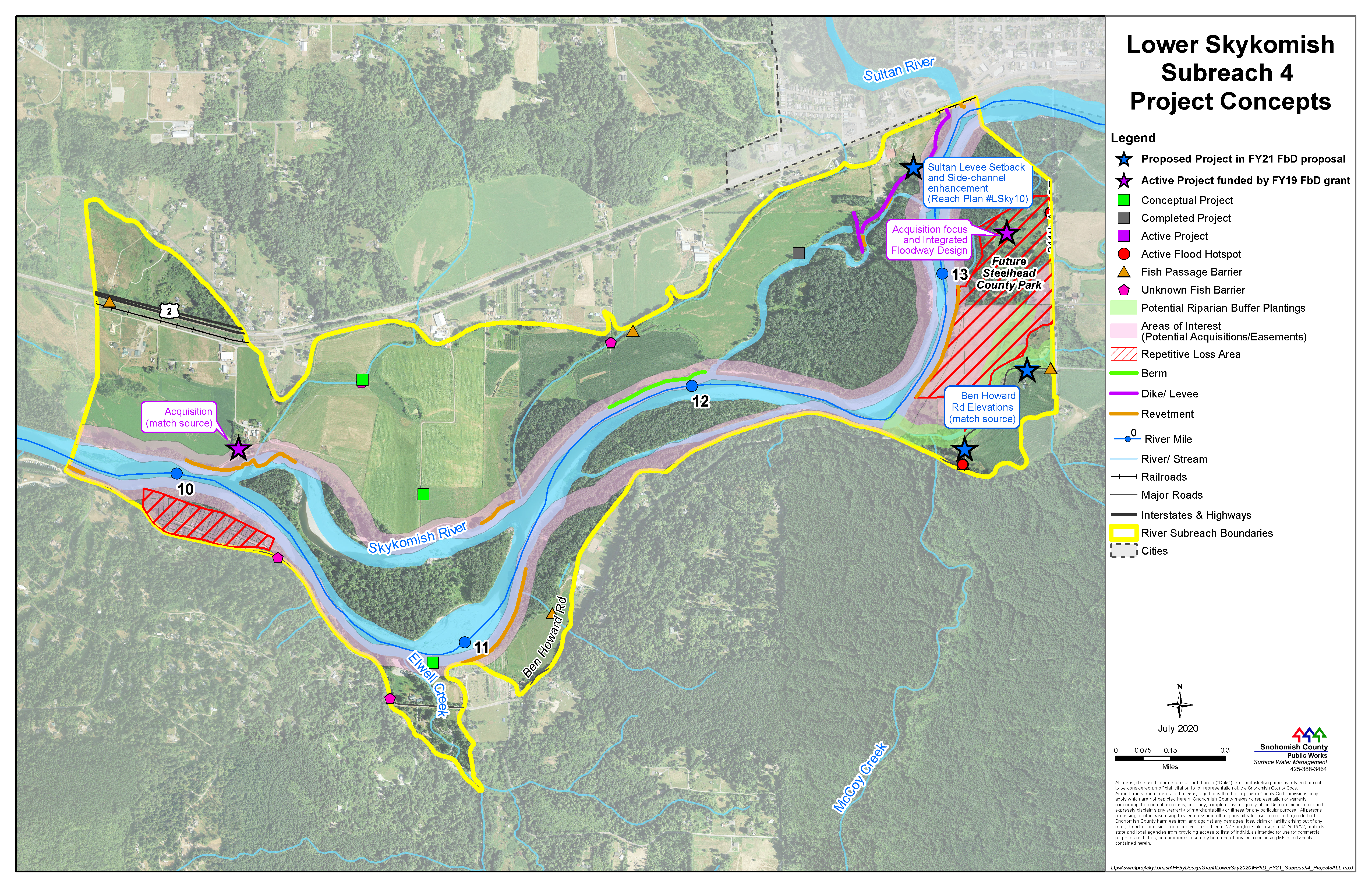
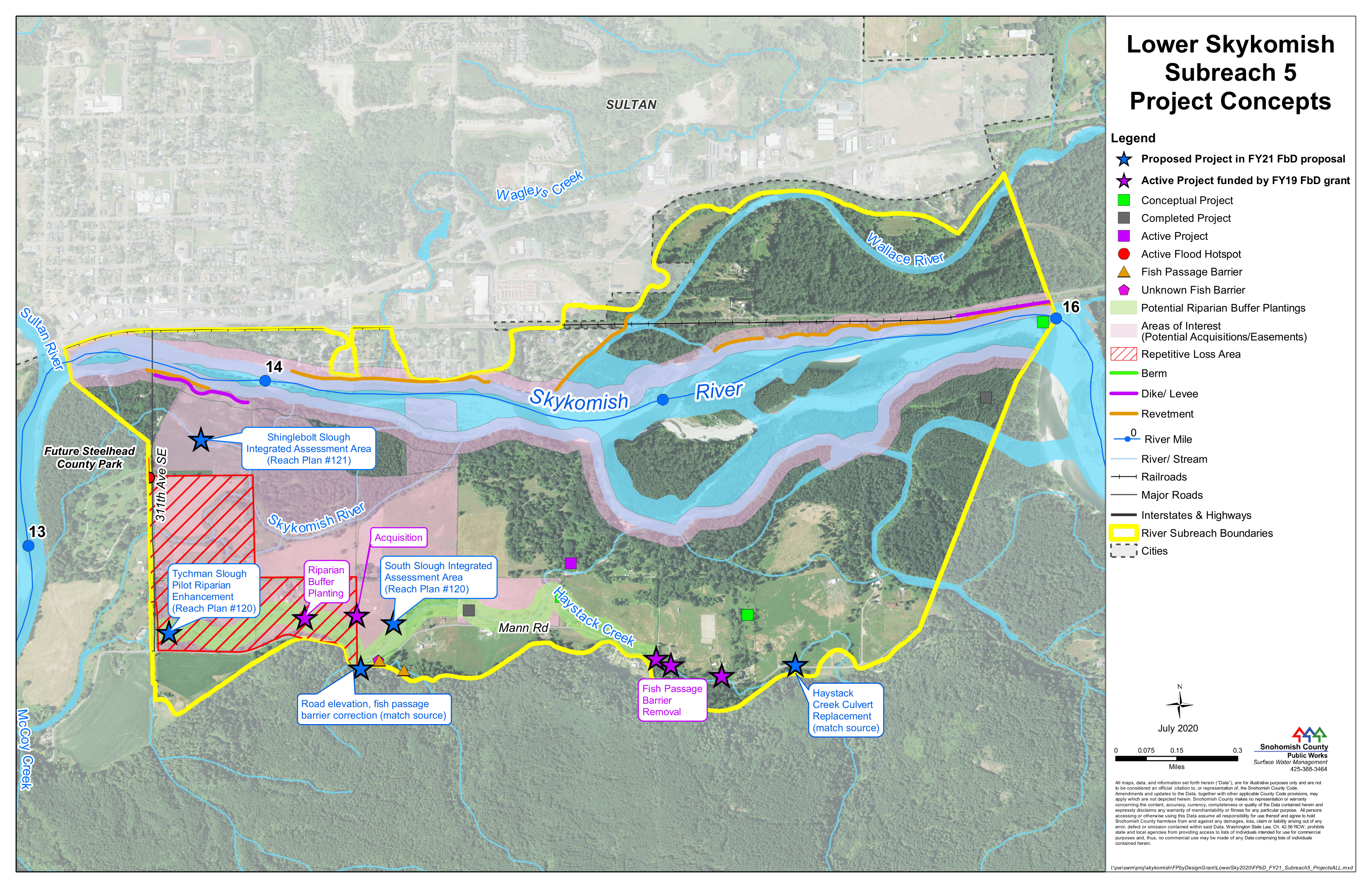
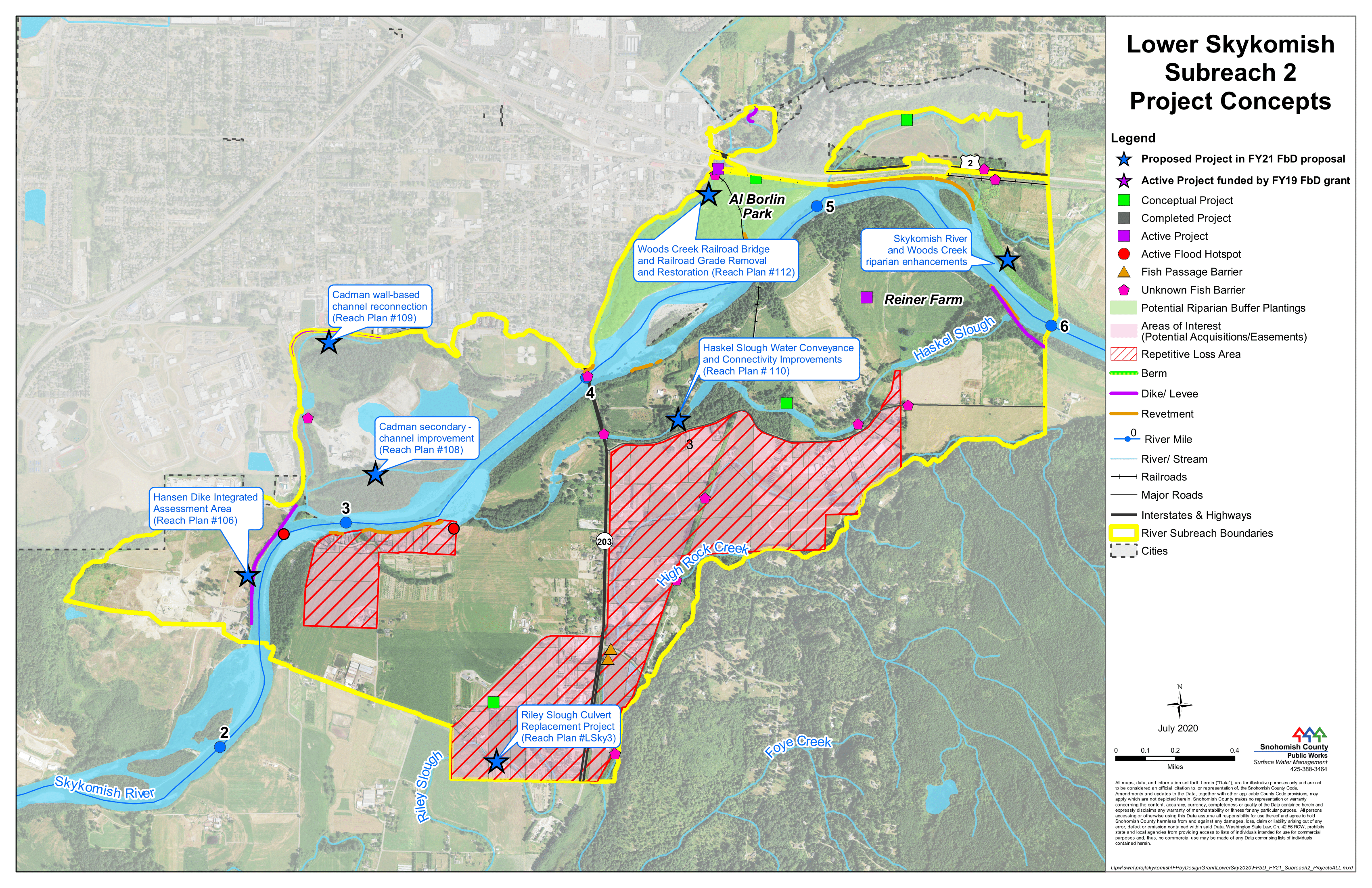
The blue and purple stars on the maps show areas we have identified as good locations for projects that integrate FARM, FISH and FLOOD priorities.
Integrated floodplain management is not just about one person’s property – we will take a “big picture” approach and look at how any potential actions could impact neighboring landowners up and downstream.
Click graphics to expand.
Phase II
We are working to secure funding for a second phase of the Community Floodplain Solutions program.
Potential multiple-benefit actions and approaches for this phase are described below and will be included as part of project feasibility analyses for all areas identified with blue stars (see the maps for Subreaches 4 and 5):
- Side channel reconnection is generally proposed in areas that are too wet to support agricultural practices. Side channel reconnections can be packaged with levee setbacks to protect agricultural areas that are farther upland from the re-routed streamflow and provide a multiple-benefit approach.
- For agricultural stability, controlling river migration and bank erosion are understandable objectives and may be the only option to protect private property in some locations. However, traditional back armoring approaches are challenging to permit and involve costly mitigation. Additionally, traditional bank armoring can transfer flood related risks to your neighbor downstream. This program instead focuses on building feasible projects that give the river more room while supporting multiple land uses that provide a public benefit. Actions like bio-engineered bank plantings are cost effective measures that provide a public benefit. See Q&A document for more on this.
- For restoration of salmon habitat that naturally forms as a result of channel migration process, several locations with limited, compatible, or willing adjacent agriculture could be enhanced by allowing for channel migration process to support salmon recovery objectives.
- Re-creation of previous channel forms can provide additional routes for water to flow and lessen the impacts to agriculture and other land uses during flood periods. These projects can also be used to reduce erosion for landowners on the opposite riverbank or can be planned to influence flows and processes farther downstream.
- Flood risk reduction efforts can also benefit long-term salmon recovery goals as well as supporting farming in the reach. For example, flood fencing keeps flood debris off agricultural fields, builds a natural berm and vegetated riparian zone to improve water quality and prevent erosion, and creates roughened edge habitat. Additionally, setting levees or revetments back reconnects floodplains that provide new access to habitat, reduces flood hazards to landowners as well as the need for long-term maintenance, and avoids the high costs of rebuilding or constructing new revetments along the river’s main channel.
- Incentives for providing ecosystem services can allow agricultural operators to balance economic pressures and maintain natural resource lands.
EXAMPLE ACTIONS: The planting of vegetation and installation of flood fencing can replicate natural processes that build river banks, catch wood and sediment before they enter farm fields, and protect mature vegetation. The installation of vertical arrays in the active river channel accelerates natural processes that build sand and gravel bars, as the structures accumulate sediment and/or wood.
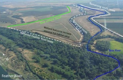
EXAMPLE of a levee setback project on the Bear River at its confluence with the Feather River in Central Valley, California. To increase the movement of flood flows and reduce backwater flooding, the north levee of the Bear and a section of levee along the Feather River were removed (white dashed line) and a two-mile long setback levee was built (green line). The project lowered flood risk along the Bear River and restored hundreds of acres of floodplain habitat. Source: “A Flood of Benefits: Using Green Infrastructure to Reduce Flood Risks”
Click graphics to expand.
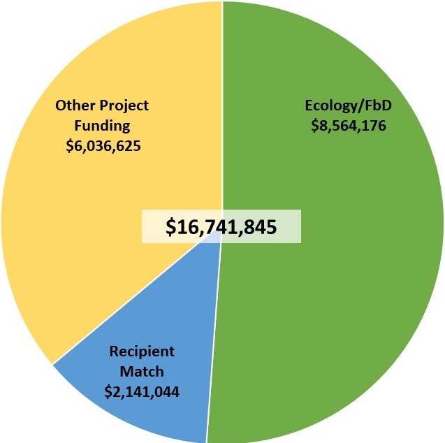
CFS Phase II would further the integrated floodplain management approach funded in 2019 and leverage additional funding sources to expand the scope of existing projects. With a total cost of over $16M, the project would generate over 260 new or sustained jobs and roughly $35M – 40M in total economic activity, of which $28.2-32M would stay within Snohomish County.
Next Steps for Project Development
- Various areas have been identified as potential multiple-benefit project opportunities within the Lower Skykomish Reach Scale plan by CFS partners and the residents living and working in these areas.
- Funding will support feasibility studies and 30% designs for multiple-benefit projects.
- A process of scoping, design review, and design charettes will be utilized to gather public input throughout the project development and design process.
- While some of these areas are publicly owned, many of them are on private property. As such, landowner willingness is an important part of the scoping process. If landowners are not willing to participate, some areas may not be feasible for us to do projects or acquisitions.
- This open house is part of the project scoping process.
- Please give us feedback on actions or treatments you’d like to see pursued in these (or other) areas. Please also include input on conditions or concerns you’d like evaluated as part of project feasibility.
- CFS projects are guided by the Snohomish Integration Team, which includes representatives from cities, Snohomish County, the Tulalip Tribes, the WA Farmland Trust, Snohomish Conservation District and Washington Department of Fish and Wildlife (WDFW). This team will work to implement the feasibility studies and 30% design process.
Feedback and Q&A
The CFS virtual Open House is no longer accepting comments, but we welcome your questions any time via email or phone. To start a conversation, please call 425-262-2443 or email CFS.info@snoco.org. And, if you haven’t done so, please sign up to stay informed about future meetings and updates.
Hope alone won’t get the job done – we need you.
We still have many decisions to make about which tools to utilize where, and we need your input to move forward. We are working to protect and enhance the quality of life in floodplain communities, and make them places where future generations can enjoy the rural, agricultural, and natural values we cherish today. Landowner participation and local support – YOUR support – is needed to achieve our mission of protecting FARM, FISH and FLOOD uses in Snohomish County.
We thank you for participating in this virtual open house! Please feel free to contact the CFS project team at any time.
Email: CFS.info@snoco.org
Call: (425) 262-2443