
S.R. 85 Virtual Project Update
Project Schedule & Process
The next step is to incorporate your input from this virtual public meeting into our decision-making process. Following your feedback, draft environmental and preliminary engineering documents will be prepared and a preferred alternative will be identified. The preferred alternative and related analyses will be presented at a public hearing. The public hearing is anticipated to be held in the spring of 2021.
Project Schedule

Transportation Develoment Process

Purpose & Need
The purpose of this project is to reduce congestion while improving traffic flow and enhancing safety along S.R. 85 from S.R. 123 to Mirage Avenue.

Capacity
- S.R. 85 near I-10 operates at an unacceptable daily level of service (LOS).
- Peak congestion in the afternoon extends from the S.R. 85/I-10 interchange four miles south near Special Forces Way, resulting in travel times of 30 minutes or more.
- The failing level of service will worsen with continued growth in the area.

System Linkage
- S.R. 85 provides an important connection between north and south Okaloosa County.
- S.R. 85 is designated as a Strategic Intermodal System, Military Access Facility.
- S.R. 85 is on the Strategic Highway Network and identified as a Highway of Commerce by the Okaloosa- Walton Transportation Planning Organization.

Safety
- The 2013 to 2017 crash rate for S.R. 85 is higher than the statewide averages for a similar type of roadway.
- Rear-end crashes account for 50.4% of all crashes, indicating heavy traffic conditions.
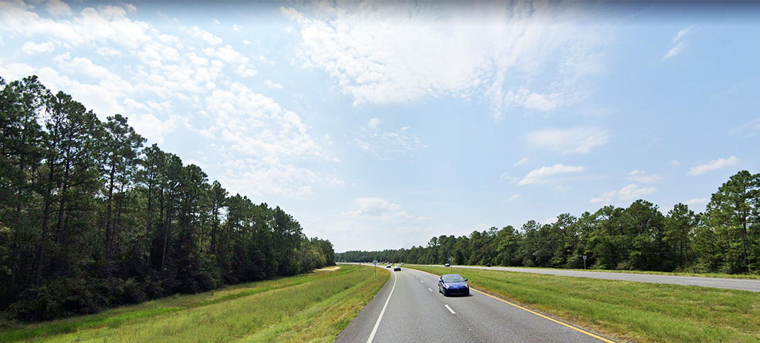
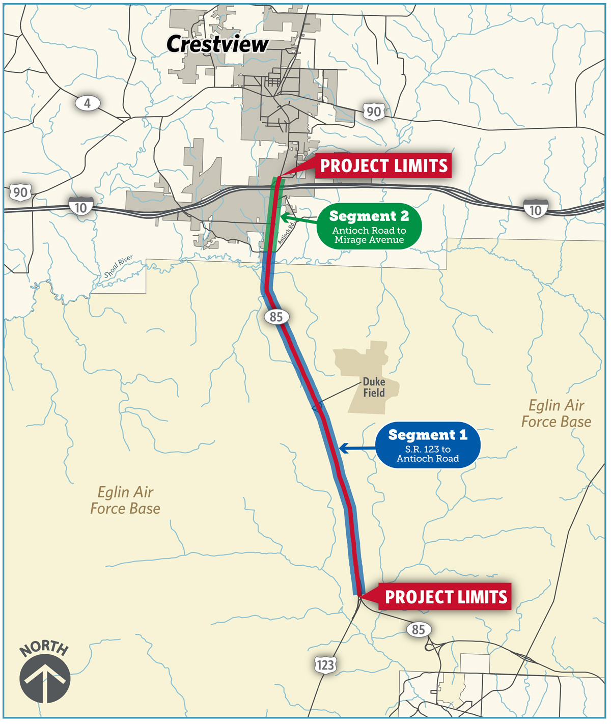
Study Area
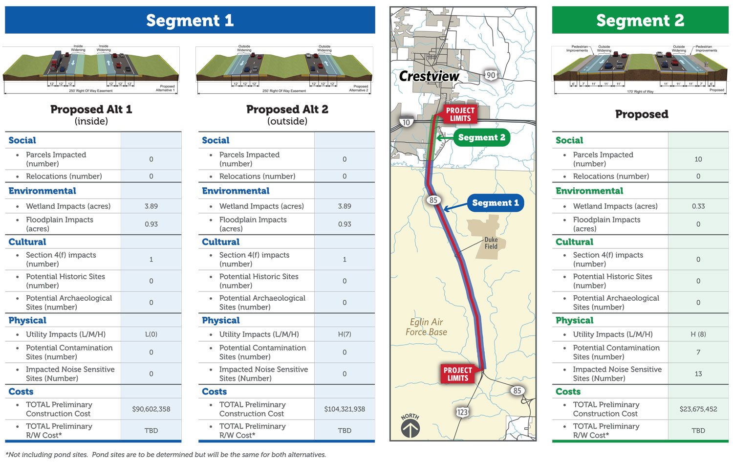
The S.R. 85 PD&E Study limits are from S.R. 123 to Mirage Avenue just north of I-10 in Okaloosa County, Florida. The project consists of two segments: Segment 1 from S.R. 123 to Antioch Road and Segment 2 from Antioch Road to Mirage Avenue.
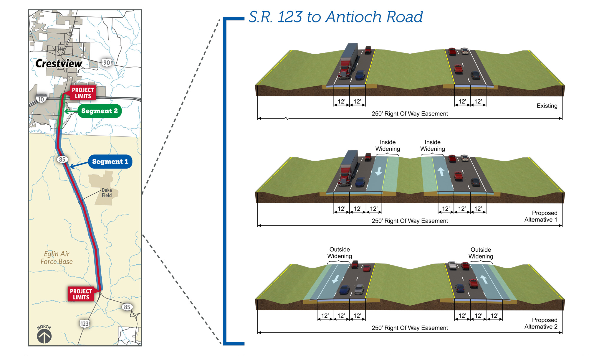
Segment 1 - Roadway Typical Section
 Click on image to enlarge
Segment 1 (S.R. 123 to Antioch Road) is in a rural area. Two typical sections are being evaluated:
- Alternative 1: Inside Widening
- Alternative 2: Outside Widening
The image shows the existing S.R. 85 typical section at the top and the inside (Alternative 1) and outside (Alternative 2) widening alternatives below it.
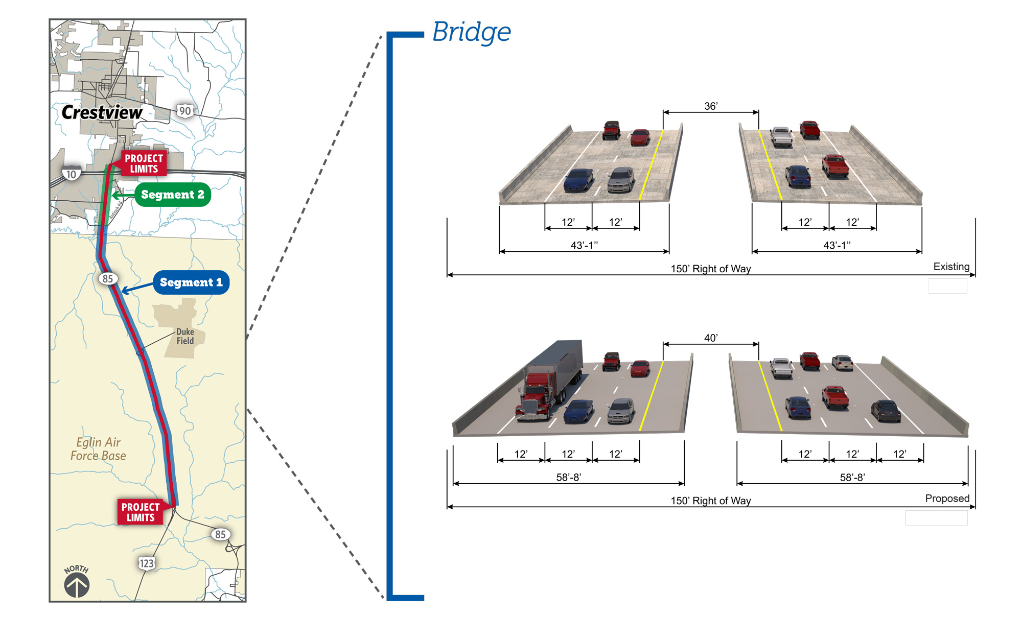
Segment 1 - Bridge over Shoal River
 Click on image to enlarge
The Bridge over Shoal River is part of Segment 1 but only inside widening is being considered at this location in order to minimize potential impacts. The image shows the existing and proposed typical sections.
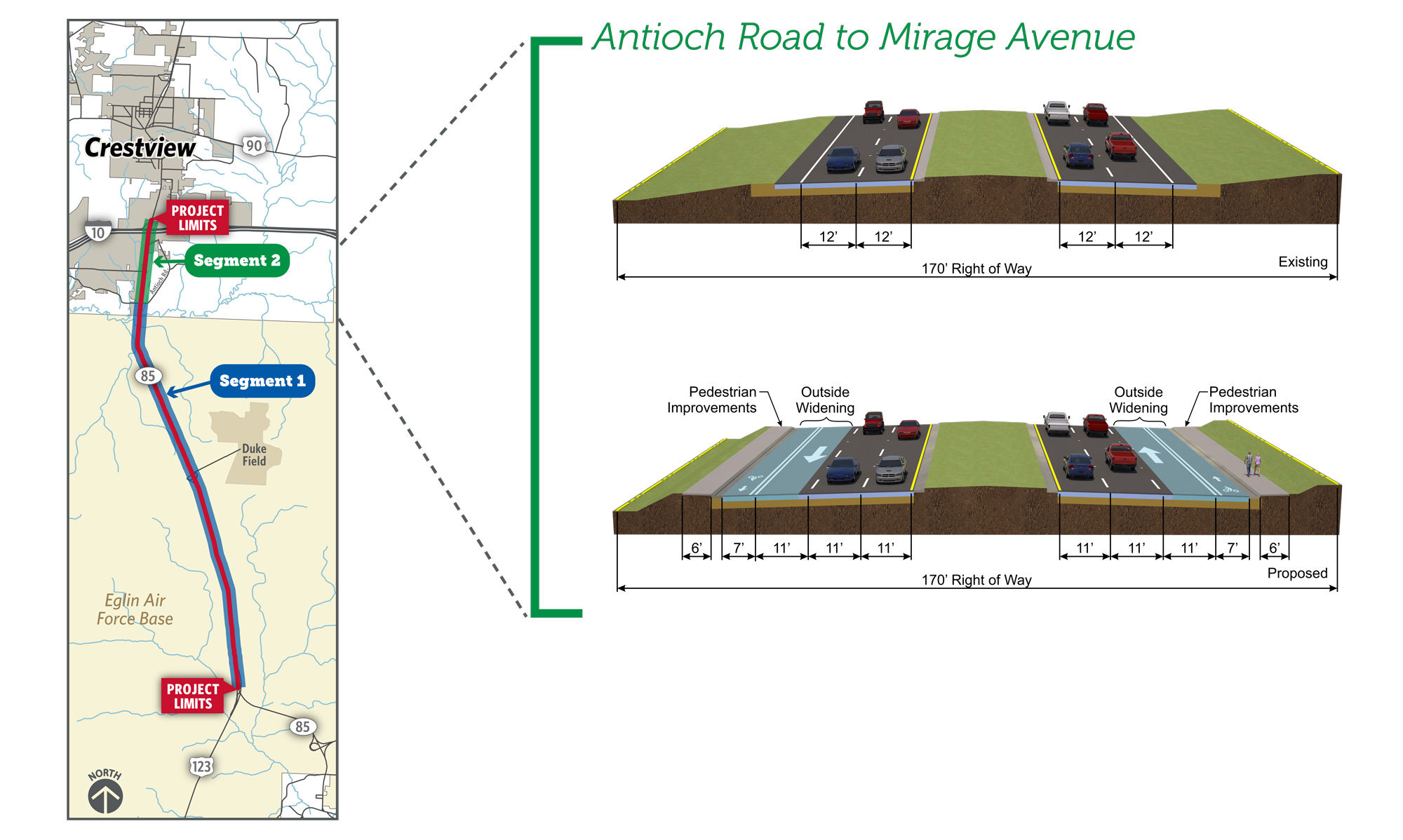
Segment 2 - Roadway Typical Section
 Click on image to enlarge
Segment 2 (Antioch Road to Mirage Avenue) is in a suburban area. Outside widening will accommodate the additional lanes and the addition of sidewalks and bicycle lanes in both directions. In this segment, the existing median is much smaller than Segment 1 and will not accommodate the additional lanes and dual left turn lanes that are required at the signalized intersections. The image shows the existing and proposed typical sections.
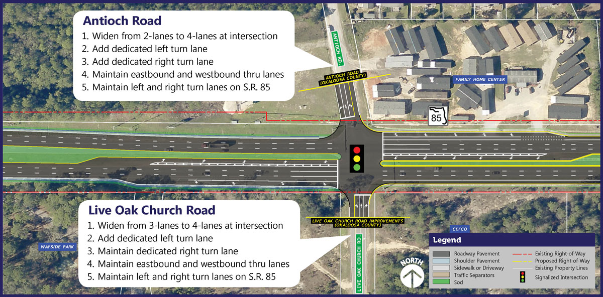
Antioch/Live Oak Church Road
 Click on image to enlarge
Intersection Improvements at Antioch Road
Widen from 2-lanes to 4-lanes at intersection:
- Add a dedicated left turn lane
- Add a dedicated right turn lane
- Maintain eastbound and westbound thru lanes
- Maintain left and right turn lanes on S.R. 85
Intersection Improvements at Live Oak Church Road
Widen from 3-lanes to 4-lanes at intersection:
- Add a dedicated left turn lane
- Maintain the dedicated right turn lane
- Maintain eastbound and westbound thru lanes
- Maintain left and right turn lanes on S.R. 85
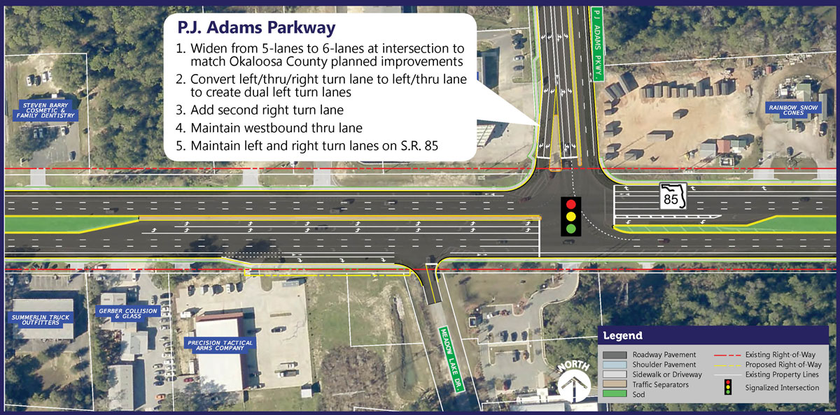
P.J. Adams Parkway
 Click on image to enlarge
Intersection Improvements at P.J. Adams Parkway
Widen from 5-lanes to 6-lanes at intersection to match Okaloosa County planned improvements:
- Convert left/thru/right turn lane to left/thru lane to create dual left turn lanes
- Add a second right turn lane
- Maintain westbound thru lanes
- Maintain left and right turn lanes on S.R. 85
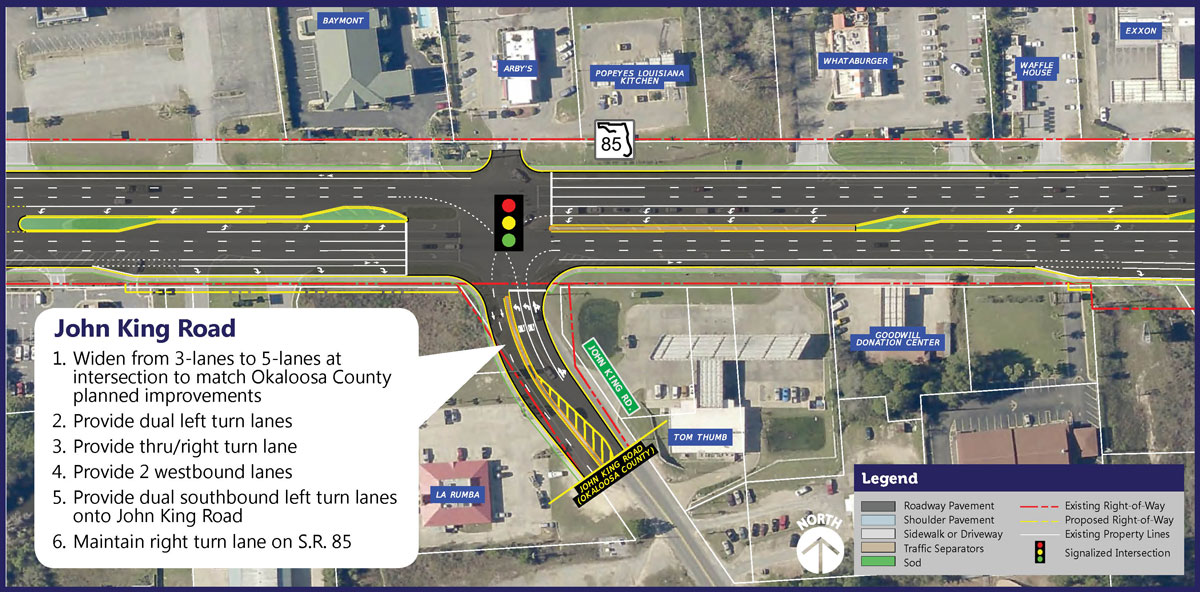
John King Road
 Click on image to enlarge
Intersection Improvements at John King Road
Widen from 3-lanes to 5-lanes at intersection to match Okaloosa County planned improvements:
- Provide dual left turn lanes
- Provide thru/right turn lane
- Provide 2 westbound lanes
- Provide dual southbound left turn lanes onto John King Road
- Maintain right turn lane on S.R. 85
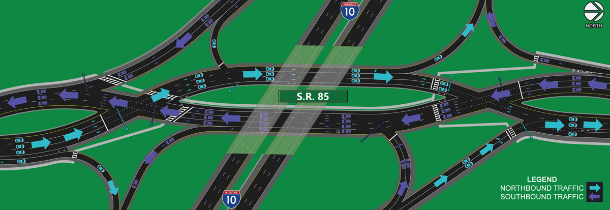
Navigating a Diverging Diamond Interchange
The Diverging Diamond Interchange (DDI) is an innovative, proven solution for improving safety and mobility at interchanges. The DDI resembles a typical diamond interchange, except that all traffic along the crossroad travels on the left-hand side to aid unopposed left-turns to and from the interchange ramps.
Diverging diamond interchanges are sometimes called crisscross interchanges because they eliminate the need to turn left across traffic. Instead, vehicles trade sides as interstate traffic enters or exists with a slight curve since the number of potential conflicts bdetween drivers is reduced, safety for the traveling public is increased.
 Click on image to enlarge
A DDI uses the basic diamond interchange layout: two entrance ramps, and two exit ramps.
All right turns in a DDI look and work the same way as a diamond interchange.
The crossovers gently transition - or diverge - traffic from the right side of the road to the left side of the road and then back again. Because traffic is on the left hand side between the crossovers, all left turns occur without having to cross opposing traffic. The road geometry, signs, and pavement markings all work together to make this very simple. This improves both safety and traffic operations.
Federal Highway Administration Resources
Alternatives Evaluation Matrix
This matrix summarizes the evaluation measures used to compare the S.R. 85 widening alternatives and associated intersection options. As the concept plans continue to be refined, impacts to social, environmental, cultural, and physical resources will be avoided and minimized to the extent practicable. Affected resources will be documented in the Environmental Assessment and technical memoranda which will be available prior to the public hearing which will be held in spring of 2021.
 Click on image to enlarge